A
Seller's Agent in 2020
Alice Jolley
Re/Max Of Albany

Estimated Value: $353,000 - $516,000
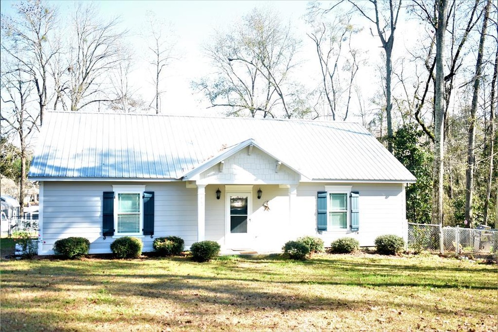
WAKE UP TO TRANQUILITY AND PEACE IN YOUR OWN VACATION PARADISE! FISHING IN YOUR OWN BACK YARD!! Boat Dock being completed! Back yard fenced and another fencing area for your dogs! RELAX in your SUNROOM with your Coffee or just enjoy the VIEW from the large picture windows! Inviting foyer greets you from front of home. Living Room and Kitchen Area open so you can enjoy the view from LARGE picture windows!!! Space is wonderful in large Master Bedroom and Bathroom featuring a large walk-in closet! Laundry closet. Nice 2nd bathroom and 2 good sized bedrooms. Vacant lot beside you gives good privacy. ALL YOU NEED IS A BOAT OR JUST FISH FROM THE SHORE!
Last Agent to Sell the Property
Alice Jolley
Re/Max Of Albany Brokerage Phone: 2294341600 Listed on: 05/07/2020

Last Buyer's Agent
Alice Jolley
Re/Max Of Albany Brokerage Phone: 2294341600 Listed on: 05/07/2020
| Date | Buyer | Sale Price | Title Company |
|---|---|---|---|
| Mcdaniel Delmar Gene | -- | -- | |
| Mcdaniel Delmar Gene | $217,000 | -- | |
| Parker Charles Preston | -- | -- |
| Date | Status | Borrower | Loan Amount |
|---|---|---|---|
| Open | Mcdaniel Delmar Gene | $173,600 | |
| Closed | Mcdaniel Delmar Gene | $173,600 |
| Date | Event | Price | List to Sale | Price per Sq Ft |
|---|---|---|---|---|
| 07/24/2020 07/24/20 | Sold | $217,000 | -- | $136 / Sq Ft |
| 05/07/2020 05/07/20 | Pending | -- | -- | -- |
| Year | Tax Paid | Tax Assessment Tax Assessment Total Assessment is a certain percentage of the fair market value that is determined by local assessors to be the total taxable value of land and additions on the property. | Land | Improvement |
|---|---|---|---|---|
| 2025 | $1,500 | $177,629 | $89,289 | $88,340 |
| 2024 | $264 | $77,169 | $18,105 | $59,064 |
| 2023 | $264 | $70,105 | $18,105 | $52,000 |
| 2022 | $264 | $70,105 | $18,105 | $52,000 |
| 2021 | $240 | $70,105 | $18,105 | $52,000 |
| 2020 | $2,249 | $70,105 | $18,105 | $52,000 |
| 2019 | $2,249 | $70,105 | $18,105 | $52,000 |
| 2018 | $2,009 | $70,105 | $18,105 | $52,000 |
| 2017 | $2,009 | $70,105 | $18,105 | $52,000 |
| 2016 | $2,009 | $70,105 | $18,105 | $52,000 |
| 2015 | -- | $39,308 | $39,308 | $0 |
A
Seller's Agent in 2020
Alice Jolley
Re/Max Of Albany
Source: Albany Board of REALTORS®
MLS Number: 144491
APN: 00360-003-00A
Ask me questions while you tour the home.