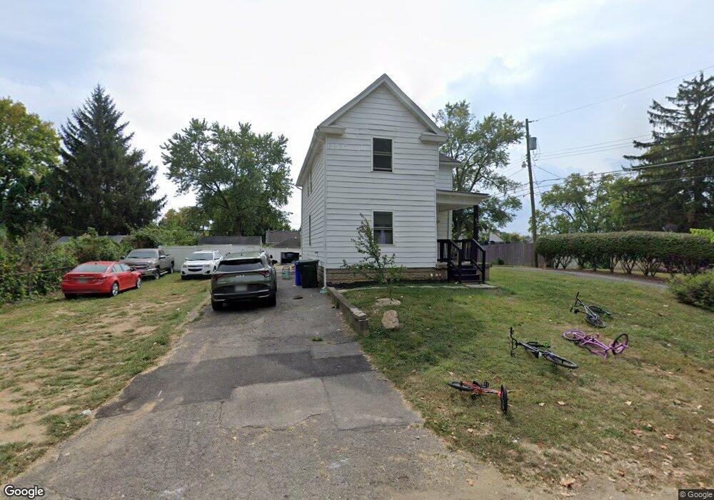
67 Kail Ave Columbus, OH 43207
Obetz-Lockbourne NeighborhoodEstimated Value: $191,686 - $266,000
About This Home
This home is located at 67 Kail Ave, Columbus, OH 43207 and is currently estimated at $225,922, approximately $41 per square foot. 67 Kail Ave is a home located in Franklin County with nearby schools including Parsons Elementary School, Buckeye Middle School, and Marion-Franklin High School.
Ownership History
We collect this data history from publicly available records. To have your information removed, we recommend requesting removal directly through your county’s website.
Purchase Details
Purchase Details
Home Financials for this Owner
Home Financials are based on the most recent Mortgage that was taken out on this home.Purchase Details
Purchase Details
Purchase Details
Home Financials for this Owner
Home Financials are based on the most recent Mortgage that was taken out on this home.Purchase Details
Home Values in the Area
Average Home Value in this Area
Purchase History
We collect this data history from publicly available records. To have your information removed, we recommend requesting removal directly through your county’s website.
| Date | Buyer | Sale Price | Title Company |
|---|---|---|---|
| -- | None Available | ||
| -- | Ohio Real Title Agency Llc | ||
| $27,500 | Omega Title Agency Llc | ||
| $55,000 | Nova Title | ||
| $55,900 | Land Sel Title | ||
| -- | -- |
Mortgage History
We collect this data history from publicly available records. To have your information removed, we recommend requesting removal directly through your county’s website.
| Date | Status | Borrower | Loan Amount |
|---|---|---|---|
| Previous Owner | $131,250 | ||
| Previous Owner | $54,887 |
Tax History
We collect this data history from publicly available records. To have your information removed, we recommend requesting removal directly through your county’s website.
| Year | Tax Paid | Tax Assessment Tax Assessment Total Assessment is a certain percentage of the fair market value that is determined by local assessors to be the total taxable value of land and additions on the property. | Land | Improvement |
|---|---|---|---|---|
| 2025 | $2,745 | $59,890 | $11,690 | $48,200 |
| 2024 | $2,745 | $59,890 | $11,690 | $48,200 |
| 2023 | $3,023 | $59,890 | $11,690 | $48,200 |
| 2022 | $1,730 | $33,360 | $6,270 | $27,090 |
| 2021 | $1,776 | $33,360 | $6,270 | $27,090 |
| 2020 | $1,779 | $33,360 | $6,270 | $27,090 |
| 2019 | $1,796 | $28,320 | $5,460 | $22,860 |
| 2018 | $1,509 | $28,320 | $5,460 | $22,860 |
| 2017 | $1,576 | $28,320 | $5,460 | $22,860 |
| 2016 | $1,435 | $21,670 | $2,940 | $18,730 |
| 2015 | $1,303 | $21,670 | $2,940 | $18,730 |
| 2014 | $779 | $21,670 | $2,940 | $18,730 |
| 2013 | $417 | $22,785 | $3,080 | $19,705 |
Map
- 2654 Shelly Dr
- 212 E Alcott Rd
- 2822 S High St
- 125 Schryver Rd
- 2737 Gibson Dr
- 256 Loxley Dr
- 2779 Gibson Dr
- 103 Benfield Ave
- 231 Schryver Rd
- 78 Southgate Dr
- 2404 S 5th St
- 2407 S 6th St
- 2405 S 6th St
- 2986 Lee Ellen Place
- 2382 S 6th St
- 209 Currier Dr
- 3142 Hillgate Rd
- 611 Lock Ave
- 486 Basswood Rd
- 492 Basswood Rd
- 81 Kail Ave
- 2694 Thorndale Ave
- 2684 Thorndale Ave
- 2706 Thorndale Ave
- 85 Kail Ave
- 74 E Alcott Rd
- 86 E Alcott Rd
- 72 Kail Ave
- 72 Kail Ave
- 0 Kail Ave
- 2672 Thorndale Ave
- 2710 Thorndale Ave
- 92 E Alcott Rd
- 84 Kail Ave
- 98 E Alcott Rd
- 109 Kail Ave
- 2658 Thorndale Ave
- 2691 Thorndale Ave
- 2681 Thorndale Ave
- 112 E Alcott Rd
Ask me questions while you tour the home.