Estimated Value: $613,337 - $739,000
Studio
--
Bath
1,594
Sq Ft
$437/Sq Ft
Est. Value
About This Home
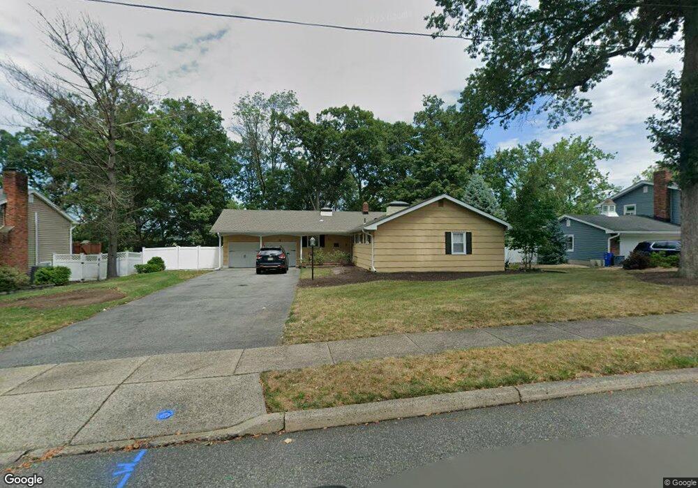
This home is located at 67 Rande Dr, Wayne, NJ 07470 and is currently estimated at $696,084, approximately $436 per square foot. 67 Rande Dr is a home located in Passaic County with nearby schools including Randall Carter School, George Washington Middle School, and Wayne Valley High School.
Ownership History
Date
Name
Owned For
Owner Type
Purchase Details
Closed on
Aug 2, 2021
Sold by
Molner Robert J and Molner Joan S
Bought by
Molner Ryan and Shivkumar Swati
Current Estimated Value
Home Financials for this Owner
Home Financials are based on the most recent Mortgage that was taken out on this home.
Original Mortgage
$397,800
Interest Rate
2.98%
Mortgage Type
New Conventional
Purchase Details
Closed on
Sep 23, 1997
Sold by
Ratajczak George and Ratajczak Deborah
Bought by
Molner Robert J and Molner Joan S
Home Financials for this Owner
Home Financials are based on the most recent Mortgage that was taken out on this home.
Original Mortgage
$212,800
Interest Rate
7.48%
Create a Home Valuation Report for This Property
The Home Valuation Report is an in-depth analysis detailing your home's value as well as a comparison with similar homes in the area
Home Values in the Area
Average Home Value in this Area
Purchase History
| Date | Buyer | Sale Price | Title Company |
|---|---|---|---|
| Molner Ryan | $497,250 | Majestic Title | |
| Molner Ryan | $497,250 | Majestic Title | |
| Molner Robert J | $266,000 | -- |
Source: Public Records
Mortgage History
| Date | Status | Borrower | Loan Amount |
|---|---|---|---|
| Previous Owner | Molner Ryan | $397,800 | |
| Previous Owner | Molner Robert J | $212,800 |
Source: Public Records
Tax History
| Year | Tax Paid | Tax Assessment Tax Assessment Total Assessment is a certain percentage of the fair market value that is determined by local assessors to be the total taxable value of land and additions on the property. | Land | Improvement |
|---|---|---|---|---|
| 2025 | $12,029 | $202,300 | $100,900 | $101,400 |
| 2024 | $11,568 | $202,300 | $100,900 | $101,400 |
| 2022 | $11,438 | $202,300 | $100,900 | $101,400 |
| 2021 | $11,426 | $202,300 | $100,900 | $101,400 |
| 2020 | $11,375 | $202,300 | $100,900 | $101,400 |
| 2019 | $11,155 | $202,300 | $100,900 | $101,400 |
| 2018 | $11,056 | $202,300 | $100,900 | $101,400 |
| 2017 | $10,955 | $202,300 | $100,900 | $101,400 |
| 2016 | $10,801 | $202,300 | $100,900 | $101,400 |
| 2015 | $10,671 | $202,300 | $100,900 | $101,400 |
| 2014 | $10,370 | $202,300 | $100,900 | $101,400 |
Source: Public Records
Map
Nearby Homes
- 10 Winonah Ave
- 16 Gressinger Rd
- 73 Maple Ave
- 49 Laguna Dr
- 119 Herrick Rd
- 249 Parish Dr
- 53 Laurel Dr
- 25-27 Newark Pompton Turnpike
- 208 Fayette Ave
- 278 French Hill Rd
- 31 Brookside Rd
- 27 Archung Rd
- 2 Brookside Rd
- 10 Lake Dr W
- 450 Boonton Turnpike
- 10 Minnehaha Path
- 47 Matthew Rd
- 193 Newark Pompton Turnpike
- 201 Newark Pompton Turnpike
- 30 S Valley Rd
Your Personal Tour Guide
Ask me questions while you tour the home.