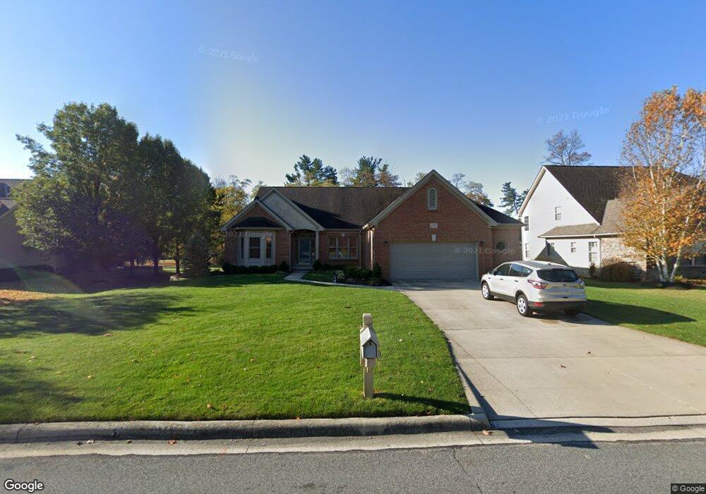
672 Covered Bridge Dr Delaware, OH 43015
Estimated Value: $459,000 - $570,000
3
Beds
2
Baths
2,131
Sq Ft
$233/Sq Ft
Est. Value
About This Home
This home is located at 672 Covered Bridge Dr, Delaware, OH 43015 and is currently estimated at $497,269, approximately $233 per square foot. 672 Covered Bridge Dr is a home located in Delaware County with nearby schools including Cheshire Elementary School, Hyatts Middle School, and Olentangy Berlin High School.
Ownership History
Date
Name
Owned For
Owner Type
Purchase Details
Closed on
Dec 31, 2003
Sold by
Pusateri Joseph J and Pusateri Deborah L
Bought by
Pusateri Joseph J and Pusateri Deborah L
Current Estimated Value
Purchase Details
Closed on
Nov 27, 2000
Sold by
Romanelli & Hughes Bldg
Bought by
Pusateri Joseph J and Pusateri Deborah L
Home Financials for this Owner
Home Financials are based on the most recent Mortgage that was taken out on this home.
Original Mortgage
$125,000
Outstanding Balance
$46,627
Interest Rate
7.87%
Mortgage Type
New Conventional
Estimated Equity
$450,642
Purchase Details
Closed on
May 9, 2000
Sold by
New Green Highlands Dev
Bought by
Romanelli & Hughes Building Co
Create a Home Valuation Report for This Property
The Home Valuation Report is an in-depth analysis detailing your home's value as well as a comparison with similar homes in the area
Home Values in the Area
Average Home Value in this Area
Purchase History
| Date | Buyer | Sale Price | Title Company |
|---|---|---|---|
| Pusateri Joseph J | -- | -- | |
| Pusateri Joseph J | $314,365 | -- | |
| Romanelli & Hughes Building Co | $58,400 | -- |
Source: Public Records
Mortgage History
| Date | Status | Borrower | Loan Amount |
|---|---|---|---|
| Open | Pusateri Joseph J | $125,000 |
Source: Public Records
Tax History
| Year | Tax Paid | Tax Assessment Tax Assessment Total Assessment is a certain percentage of the fair market value that is determined by local assessors to be the total taxable value of land and additions on the property. | Land | Improvement |
|---|---|---|---|---|
| 2024 | $7,056 | $128,140 | $29,790 | $98,350 |
| 2023 | $6,763 | $128,140 | $29,790 | $98,350 |
| 2022 | $6,776 | $101,330 | $22,050 | $79,280 |
| 2021 | $6,817 | $101,330 | $22,050 | $79,280 |
| 2020 | $6,850 | $101,330 | $22,050 | $79,280 |
| 2019 | $6,439 | $99,020 | $22,050 | $76,970 |
| 2018 | $6,468 | $99,020 | $22,050 | $76,970 |
| 2017 | $6,402 | $89,260 | $27,550 | $61,710 |
| 2016 | $6,217 | $89,260 | $27,550 | $61,710 |
| 2015 | $5,631 | $89,260 | $27,550 | $61,710 |
| 2014 | $5,707 | $89,260 | $27,550 | $61,710 |
| 2013 | $5,744 | $89,260 | $27,550 | $61,710 |
Source: Public Records
Map
Nearby Homes
- 680 Covered Bridge Dr
- 1464 Kenneth Dr
- 2790 Royal Dornoch Cir
- 81 Littondale Dr
- 389 Stansted Dr
- 119 Littondale Dr
- 96 Littondale Dr
- 102 Littondale Dr
- 120 Littondale Dr
- 132 Littondale Dr
- 389 Inverness Ave
- 413 Broad Furrows Ave
- 774 Grassington Crossing
- 1226 Skipton Loop
- 1203 Skipton Loop
- 1179 Skipton Loop
- 3434 Royal Dornoch Cir
- 114 Stoneybank Dr Unit 15692 Developer Lot
- 90 Stoneybank Dr
- 102 Stoneybank Dr Unit 15694, Developer lo
- 2763 Mid Pines Ct
- 2777 Mid Pines Ct
- 688 Covered Bridge Dr
- 2805 Mid Pines Ct
- 662 Mid Pines Ct
- 0 Covered Bridge Dr Unit L910 2026773
- 0 Covered Bridge Dr Unit L929 2005121
- 0 Covered Bridge Dr Unit L355 2007421
- 0 Covered Bridge Dr Unit L357 2007425
- 0 Covered Bridge Dr Unit L356 2007424
- 0 Covered Bridge Dr Unit L354 2007420
- 0 Covered Bridge Dr Unit L353 2007419
- 0 Covered Bridge Dr Unit L352 2007417
- 0 Covered Bridge Dr Unit L955 2005129
- 0 Covered Bridge Dr Unit L937 2005125
- 1006 Covered Bridge Dr
- 825 Covered Bridge Dr
- 0 Covered Bridge Dr Unit L398 2014153
- 0 Covered Bridge Dr Unit 2010360
- 0 Covered Bridge Dr Unit L-356 2200488
Your Personal Tour Guide
Ask me questions while you tour the home.