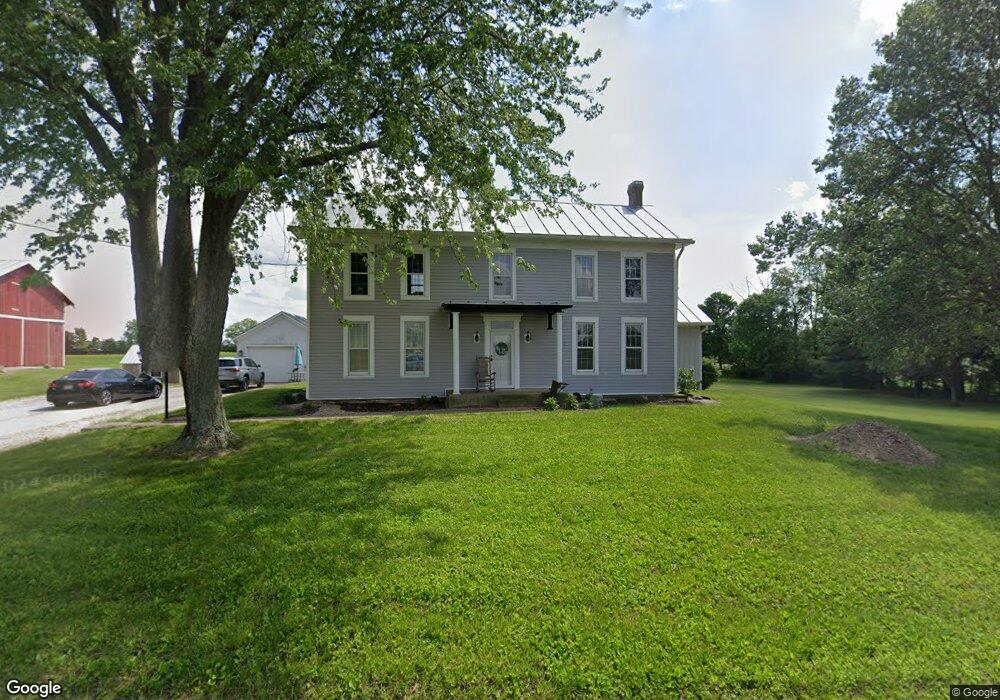
6738 E State Route 55 Casstown, OH 45312
Estimated Value: $406,000 - $537,000
3
Beds
1
Bath
2,780
Sq Ft
$177/Sq Ft
Est. Value
About This Home
This home is located at 6738 E State Route 55, Casstown, OH 45312 and is currently estimated at $490,838, approximately $176 per square foot. 6738 E State Route 55 is a home located in Miami County with nearby schools including Miami East Elementary School, Miami East Junior High School, and Miami East High School.
Ownership History
Date
Name
Owned For
Owner Type
Purchase Details
Closed on
Jun 26, 2019
Sold by
Petersen Rita Duff and Duff Christopher H
Bought by
Duff Zachary H
Current Estimated Value
Home Financials for this Owner
Home Financials are based on the most recent Mortgage that was taken out on this home.
Original Mortgage
$204,000
Outstanding Balance
$177,103
Interest Rate
4%
Mortgage Type
New Conventional
Estimated Equity
$313,735
Purchase Details
Closed on
Jan 1, 1990
Bought by
Duff Max H
Create a Home Valuation Report for This Property
The Home Valuation Report is an in-depth analysis detailing your home's value as well as a comparison with similar homes in the area
Purchase History
| Date | Buyer | Sale Price | Title Company |
|---|---|---|---|
| Duff Zachary H | $255,000 | None Available | |
| Duff Max H | -- | -- |
Source: Public Records
Mortgage History
| Date | Status | Borrower | Loan Amount |
|---|---|---|---|
| Open | Duff Zachary H | $204,000 |
Source: Public Records
Tax History
| Year | Tax Paid | Tax Assessment Tax Assessment Total Assessment is a certain percentage of the fair market value that is determined by local assessors to be the total taxable value of land and additions on the property. | Land | Improvement |
|---|---|---|---|---|
| 2025 | $3,861 | $119,960 | $36,940 | $83,020 |
| 2024 | $3,861 | $88,250 | $27,210 | $61,040 |
| 2023 | $3,008 | $88,250 | $27,210 | $61,040 |
| 2022 | $3,089 | $88,250 | $27,210 | $61,040 |
| 2021 | $2,810 | $75,510 | $24,650 | $50,860 |
| 2020 | $2,825 | $75,510 | $24,650 | $50,860 |
| 2019 | $2,540 | $75,510 | $24,650 | $50,860 |
| 2018 | $2,393 | $69,350 | $32,000 | $37,350 |
| 2017 | $2,370 | $69,350 | $32,000 | $37,350 |
| 2016 | $1,577 | $51,390 | $32,000 | $19,390 |
| 2015 | $1,465 | $46,140 | $27,480 | $18,660 |
| 2014 | $1,465 | $46,140 | $27,480 | $18,660 |
| 2013 | $1,473 | $46,140 | $27,480 | $18,660 |
Source: Public Records
Map
Nearby Homes
- 3485 County Highway 6a
- 4505 N Alcony Conover Rd
- 2912 Hoying Dr
- 312 E Pike St
- 1 Dayton-Brandt Rd Unit 1
- 2 Dayton-Brandt Rd
- 4 Dayton-Brandt Rd Unit Lot 4
- 8030 E State Route 41
- 950 Rosenthal Dr
- 1728 Hunters Ridge Dr
- 1482 Lee Rd
- 1400 Troy Urbana Rd
- 1424 Michael Dr
- 4284 Deweese Rd
- 10877 Christiansburg Jackson Rd
- 1334 Skylark Dr
- 1597 Old Staunton Rd
- 1142 Lee Rd
- 505 Cherry St
- 491 Mayfield Square E
- 2435 Sodom Rd
- 2232 N State Route 201
- 2148 N State Route 201
- 2088 S State Route 201
- 0 N Rugged Hill Unit 288970
- 0 N Rugged Hill Unit 344216
- 0 N Lstck Shelby Unit 413253
- 1990 N State Route 201
- 1950 N State Route 201
- 1800 N State Route 201
- 5246 E St Rt 41
- 0 St Rt 589 Unit 581835
- 0 St Rt 589 Unit 565243
- 0 St Rt 589 Unit 351410
- 0 St Rt 589 Unit 369722
- 7435 E State Route 55
- 7503 E State Route 55
- 6075 E State Route 55
- 7111 Green Rd
- 3136 Sodom Rd
Your Personal Tour Guide
Ask me questions while you tour the home.