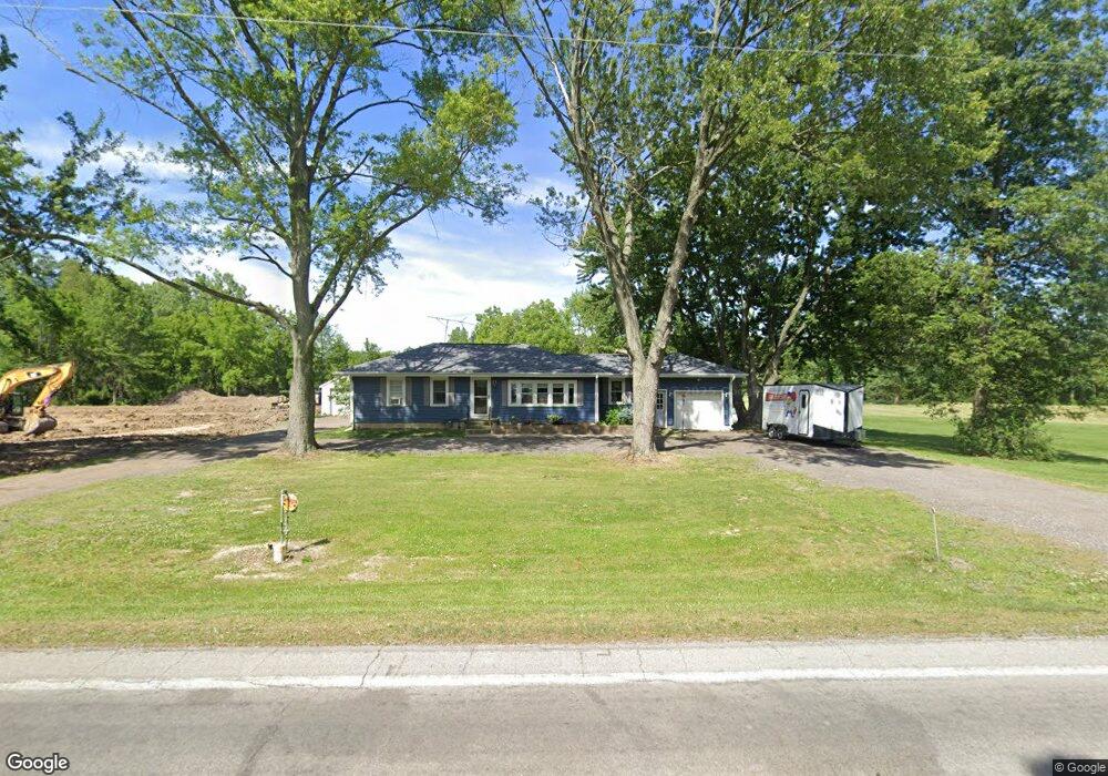
6819 State Route 186 Mc Comb, OH 45858
Estimated Value: $167,000 - $264,000
2
Beds
1
Bath
1,221
Sq Ft
$179/Sq Ft
Est. Value
About This Home
This home is located at 6819 State Route 186, Mc Comb, OH 45858 and is currently estimated at $218,734, approximately $179 per square foot. 6819 State Route 186 is a home located in Hancock County with nearby schools including Liberty-Benton Elementary School, Liberty-Benton Middle School, and Liberty-Benton High School.
Ownership History
Date
Name
Owned For
Owner Type
Purchase Details
Closed on
Aug 28, 2019
Sold by
Wilkins Robin L and Sifred Irrevocable Heritage Tr
Bought by
Siferd Suzanne and Siferds Jerry
Current Estimated Value
Home Financials for this Owner
Home Financials are based on the most recent Mortgage that was taken out on this home.
Original Mortgage
$80,000
Outstanding Balance
$61,993
Interest Rate
3.8%
Mortgage Type
New Conventional
Estimated Equity
$156,741
Purchase Details
Closed on
Jul 1, 2014
Sold by
Siferd Joann E and Siferd Jo Ann E
Bought by
Wilkins Robin L and The Siferd Irrevocable Heritage Trusts
Purchase Details
Closed on
Jun 26, 2012
Sold by
Siferd Jo Ann
Bought by
Siferd Ii Jerry L and Siferd Suzanne C
Create a Home Valuation Report for This Property
The Home Valuation Report is an in-depth analysis detailing your home's value as well as a comparison with similar homes in the area
Purchase History
| Date | Buyer | Sale Price | Title Company |
|---|---|---|---|
| Siferd Suzanne | $100,000 | Golden Key Title Agency | |
| Wilkins Robin L | -- | Attorney | |
| Siferd Ii Jerry L | -- | None Available |
Source: Public Records
Mortgage History
| Date | Status | Borrower | Loan Amount |
|---|---|---|---|
| Open | Siferd Suzanne | $80,000 |
Source: Public Records
Tax History
| Year | Tax Paid | Tax Assessment Tax Assessment Total Assessment is a certain percentage of the fair market value that is determined by local assessors to be the total taxable value of land and additions on the property. | Land | Improvement |
|---|---|---|---|---|
| 2024 | $2,296 | $61,490 | $18,490 | $43,000 |
| 2023 | $2,242 | $61,490 | $18,490 | $43,000 |
| 2022 | $2,224 | $61,490 | $18,490 | $43,000 |
| 2021 | $1,856 | $45,250 | $17,030 | $28,220 |
| 2020 | $1,868 | $45,250 | $17,030 | $28,220 |
| 2019 | $1,792 | $45,250 | $17,030 | $28,220 |
| 2018 | $1,467 | $40,050 | $14,190 | $25,860 |
| 2017 | $757 | $40,050 | $14,190 | $25,860 |
| 2016 | $1,479 | $40,050 | $14,190 | $25,860 |
| 2015 | $1,484 | $39,410 | $14,190 | $25,220 |
| 2014 | $1,502 | $39,410 | $14,190 | $25,220 |
| 2012 | $1,469 | $36,920 | $14,190 | $22,730 |
Source: Public Records
Map
Nearby Homes
- 7514 Township Road 95
- 7780 Township Road 89
- 4609 Township Road 235
- 131 E South St
- 257 S Main St
- 128 S Liberty St
- 203 E Perrin Ave
- 3111 Township Road 93
- 223 Cherry St
- 9882 U S 224
- 9960 W 224 Us Hwy
- 9894 Smokies Way
- 0 County Road 140
- 0 County Road 95 Unit 6097574
- 9307 W State Route 12
- 3470 Ohio 235
- 4014 County Road 139
- 0 Rock Candy Rd Unit Lot 159
- 0 Rock Candy Rd Unit Lot 170
- 0 Rock Candy Rd Unit Lot 172 206819
- 6814 State Route 186
- 6774 State Route 186
- 6814 S R 186
- 6748 State Route 186
- 6748 Ohio 186
- 6720 State Route 186
- 6350 Township Road 93
- 6936 State Route 186
- 6260 Township Road 93
- 6320 Township Road 93
- 6545 Willowick Dr
- 6975 Scenic View Dr
- 6607 Willowick Dr
- 6983 Scenic View Dr
- 6540 Willowick Dr
- 6556 Willowick Dr
- 6681 Willowick Dr
- 6572 Willowick Dr
- 5995 Township Road 93
- 6632 Willowick Dr
Your Personal Tour Guide
Ask me questions while you tour the home.