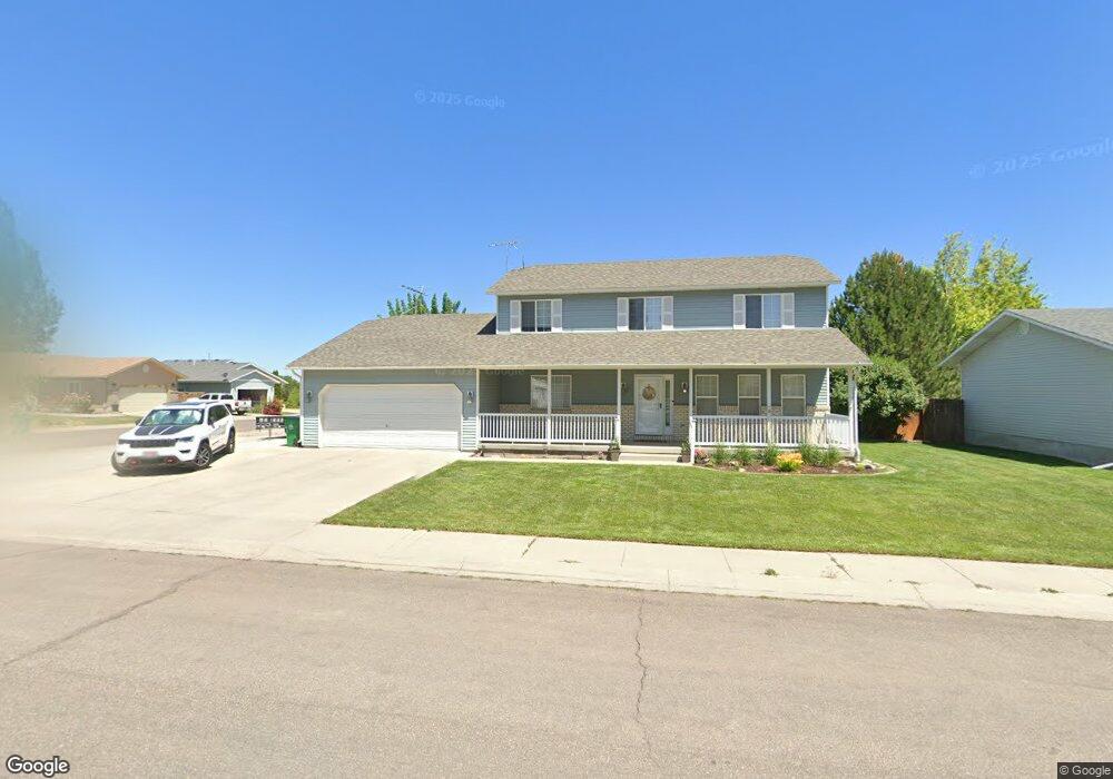
686 Mathew St Pocatello, ID 83202
Estimated Value: $413,000 - $511,000
5
Beds
3
Baths
2,978
Sq Ft
$150/Sq Ft
Est. Value
About This Home
This home is located at 686 Mathew St, Pocatello, ID 83202 and is currently estimated at $445,550, approximately $149 per square foot. 686 Mathew St is a home located in Bannock County with nearby schools including Chubbuck Elementary School, Hawthorne Middle School, and Highland High School.
Ownership History
Date
Name
Owned For
Owner Type
Purchase Details
Closed on
Mar 25, 2026
Sold by
Kay Nelson and Kay Mark E
Bought by
Walker Torri and Walker Keaton
Current Estimated Value
Home Financials for this Owner
Home Financials are based on the most recent Mortgage that was taken out on this home.
Original Mortgage
$275,000
Outstanding Balance
$275,000
Interest Rate
6.09%
Mortgage Type
New Conventional
Estimated Equity
$170,550
Purchase Details
Closed on
Apr 10, 2023
Sold by
Nelson Nathan Michael
Bought by
Nelson Alicia Kay
Purchase Details
Closed on
Jul 26, 2018
Sold by
Denning Wendy K and Denning Richard G
Bought by
Nelson Alicia and Nelson Nathan
Home Financials for this Owner
Home Financials are based on the most recent Mortgage that was taken out on this home.
Original Mortgage
$211,625
Interest Rate
4.6%
Mortgage Type
New Conventional
Purchase Details
Closed on
Jun 18, 2014
Sold by
Dalpino Wendy K and Denning Wendy K
Bought by
Denning Wendy K and Denning Richard G
Create a Home Valuation Report for This Property
The Home Valuation Report is an in-depth analysis detailing your home's value as well as a comparison with similar homes in the area
Home Values in the Area
Average Home Value in this Area
Purchase History
| Date | Buyer | Sale Price | Title Company |
|---|---|---|---|
| Walker Torri | -- | Amerititle | |
| Nelson Alicia Kay | -- | -- | |
| Nelson Alicia | -- | Alliance Title | |
| Denning Wendy K | -- | None Available |
Source: Public Records
Mortgage History
| Date | Status | Borrower | Loan Amount |
|---|---|---|---|
| Open | Walker Torri | $275,000 | |
| Previous Owner | Nelson Alicia | $211,625 |
Source: Public Records
Tax History
| Year | Tax Paid | Tax Assessment Tax Assessment Total Assessment is a certain percentage of the fair market value that is determined by local assessors to be the total taxable value of land and additions on the property. | Land | Improvement |
|---|---|---|---|---|
| 2025 | $2,495 | $365,055 | $69,000 | $296,055 |
| 2024 | $2,745 | $338,430 | $69,000 | $269,430 |
| 2023 | $3,065 | $364,127 | $69,000 | $295,127 |
| 2022 | $3,065 | $283,187 | $51,750 | $231,437 |
| 2021 | $2,663 | $283,187 | $51,750 | $231,437 |
| 2020 | $2,364 | $253,567 | $51,750 | $201,817 |
| 2019 | $2,565 | $232,471 | $41,400 | $191,071 |
| 2018 | $2,086 | $189,226 | $30,000 | $159,226 |
| 2017 | $2,038 | $189,226 | $30,000 | $159,226 |
| 2016 | $2,035 | $189,226 | $30,000 | $159,226 |
| 2015 | $1,906 | $0 | $0 | $0 |
| 2012 | -- | $173,549 | $29,000 | $144,549 |
Source: Public Records
Map
Nearby Homes
- 5540 Trueman St
- 5530 Trueman Unit D
- LOTS 56-57 Sanich Dr
- 5570 Trueman St
- 819 Lucy Ln
- 5600 Trueman St
- LOTS 26-30 Sanich Dr
- 841 Mckay St
- LOTS 31-35 Sanich Dr
- LOT 1 Melody Dr
- LOTS 36-40 Sanich Dr
- LOT 2 Melody Dr
- 492 Oaktrails Ln
- LOTS 41-45 Sanich Dr
- Parcel 2 W Siphon Rd
- Parcel 3 W Siphon Rd
- Parcel 1 W Siphon Rd
- LOT 3 Melody Dr
- 693 Canal St
- 558 Canal St
Your Personal Tour Guide
Ask me questions while you tour the home.