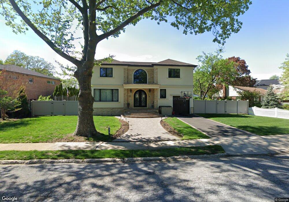
694 Laurel Dr West Hempstead, NY 11552
Estimated Value: $1,225,816 - $1,522,000
Studio
1
Bath
3,079
Sq Ft
$446/Sq Ft
Est. Value
About This Home
This home is located at 694 Laurel Dr, West Hempstead, NY 11552 and is currently estimated at $1,373,908, approximately $446 per square foot. 694 Laurel Dr is a home located in Nassau County with nearby schools including Chestnut Street School, West Hempstead Middle School, and West Hempstead Secondary School.
Ownership History
Date
Name
Owned For
Owner Type
Purchase Details
Closed on
Jan 20, 2016
Sold by
Buchalski Robert and Buchalski Robert
Bought by
Bortolis-Tsirkas Helen and Karantenislis-Schnabel Emmanuela
Current Estimated Value
Purchase Details
Closed on
Jul 3, 2014
Sold by
Buchalski Robert
Bought by
Buchalski Junior Robert
Create a Home Valuation Report for This Property
The Home Valuation Report is an in-depth analysis detailing your home's value as well as a comparison with similar homes in the area
Home Values in the Area
Average Home Value in this Area
Purchase History
| Date | Buyer | Sale Price | Title Company |
|---|---|---|---|
| Bortolis-Tsirkas Helen | $275,000 | Fidelity National Title Insu | |
| Bortolis-Tsirkas Helen | $275,000 | Fidelity National Title Insu | |
| Bortolis-Tsirkas Helen | $275,000 | Fidelity National Title Insu | |
| Buchalski Junior Robert | -- | -- | |
| Buchalski Junior Robert | -- | -- | |
| Buchalski Junior Robert | -- | -- |
Source: Public Records
Tax History
| Year | Tax Paid | Tax Assessment Tax Assessment Total Assessment is a certain percentage of the fair market value that is determined by local assessors to be the total taxable value of land and additions on the property. | Land | Improvement |
|---|---|---|---|---|
| 2025 | $16,687 | $913 | $387 | $526 |
| 2024 | $4,783 | $913 | $387 | $526 |
| 2023 | $15,051 | $550 | $387 | $163 |
| 2022 | $15,051 | $550 | $387 | $163 |
| 2021 | $20,758 | $526 | $370 | $156 |
| 2020 | $15,767 | $880 | $736 | $144 |
| 2019 | $15,997 | $880 | $736 | $144 |
| 2018 | $15,828 | $880 | $0 | $0 |
| 2017 | $6,246 | $880 | $736 | $144 |
| 2016 | $10,438 | $880 | $736 | $144 |
| 2015 | $3,732 | $880 | $736 | $144 |
| 2014 | $3,732 | $880 | $736 | $144 |
| 2013 | $3,478 | $880 | $736 | $144 |
Source: Public Records
Map
Nearby Homes
- 1010 Hempstead Ave
- 771 Maple Place
- 734 Berry Ct
- 15 Seeley Ct
- 824 Lawrence Ct
- 851 Hemlock St
- 899 Cleveland St
- 545 Mohawk Rd E
- 739 Dogwood Ave
- 1209 Hempstead Ave
- 265 Taylor Rd
- 401 Ocean Ave
- 837 Cleveland St
- 495 Rose Ave
- 853 Arthur St
- 846 Harrison St
- 815 Iris Place
- 450 Rhodes Ln
- 575 Hawthorne St
- 107 Acorn Way
- 706 Laurel Dr
- 684 Laurel Dr
- 677 Cornwell Ave
- 685 Cornwell Ave
- 714 Laurel Dr
- 664 Laurel Dr
- 693 Cornwell Ave
- 687 Laurel Dr
- 701 Cornwell Ave
- 726 Laurel Dr
- 677 Laurel Dr
- 663 Laurel Dr
- 709 Cornwell Ave
- 792 Maple Place
- 736 Laurel Dr
- 684 Cornwell Ave
- 690 Cornwell Ave
- 791 Maple Place
- 1016 Hempstead Ave
- 696 Cornwell Ave
Your Personal Tour Guide
Ask me questions while you tour the home.