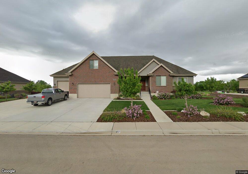
697 N 1200 E Unit 11 Mapleton, UT 84664
Estimated Value: $1,381,000 - $1,462,604
3
Beds
4
Baths
2,906
Sq Ft
$489/Sq Ft
Est. Value
About This Home
This home is located at 697 N 1200 E Unit 11, Mapleton, UT 84664 and is currently estimated at $1,421,802, approximately $489 per square foot. 697 N 1200 E Unit 11 is a home located in Utah County with nearby schools including Hobble Creek School, Mapleton Junior High School, and Maple Mountain High School.
Ownership History
Date
Name
Owned For
Owner Type
Purchase Details
Closed on
Apr 10, 2020
Sold by
Uist Curtis B and Uist Lia D
Bought by
Quist Curtis Blaine and Quist Lisa Denai
Current Estimated Value
Purchase Details
Closed on
Mar 22, 2013
Sold by
Sierra Capital L C
Bought by
Quist Curtis B and Quist Lisa D
Create a Home Valuation Report for This Property
The Home Valuation Report is an in-depth analysis detailing your home's value as well as a comparison with similar homes in the area
Home Values in the Area
Average Home Value in this Area
Purchase History
| Date | Buyer | Sale Price | Title Company |
|---|---|---|---|
| Quist Curtis Blaine | -- | Accommodation | |
| Quist Curtis B | -- | Bartlett Title Ins Ag |
Source: Public Records
Tax History
| Year | Tax Paid | Tax Assessment Tax Assessment Total Assessment is a certain percentage of the fair market value that is determined by local assessors to be the total taxable value of land and additions on the property. | Land | Improvement |
|---|---|---|---|---|
| 2025 | $6,291 | $651,310 | -- | -- |
| 2024 | $6,291 | $616,275 | $0 | $0 |
| 2023 | $6,419 | $632,775 | $0 | $0 |
| 2022 | $6,599 | $643,225 | $0 | $0 |
| 2021 | $5,472 | $818,900 | $299,700 | $519,200 |
| 2020 | $5,383 | $779,300 | $280,100 | $499,200 |
| 2019 | $5,240 | $774,300 | $275,100 | $499,200 |
| 2018 | $5,154 | $724,900 | $240,100 | $484,800 |
| 2017 | $5,267 | $393,195 | $0 | $0 |
| 2016 | $5,074 | $376,530 | $0 | $0 |
| 2015 | $4,356 | $321,255 | $0 | $0 |
| 2014 | $2,071 | $150,000 | $0 | $0 |
Source: Public Records
Map
Nearby Homes
- 1096 N 1000 E
- 775 N 800 E
- 310 N 800 E
- 1548 N 1350 St E Unit 11
- 1578 N 1350 St E Unit 12
- 1447 N 1350 St E Unit 5
- 1577 N 1350 St E Unit 1
- 1477 N 1350 St E Unit 4
- 1547 N 1350 St E Unit 2
- 1511 N 1350 St E Unit 3
- 630 N 1600 E
- 594 E 1000 N
- 162 N 800 E
- 1564 N 1700 East St
- 1515 E Maple St
- 435 E 1000 N
- 1377 E Maple St
- 745 E Maple St
- 702 N 2000 E Unit 305
- 764 N 2000 E
- 655 N 1200 E
- 739 N 1200 E
- 676 N 1200 E
- 676 N 1200 E Unit 6
- 634 N 1200 E
- 634 N 1200 E Unit 5
- 720 N 1200 E Unit 7
- 607 N 1200 E Unit 13
- 607 N 1200 E
- 767 N 1200 E
- 767 N 1200 E Unit 9
- 760 N 1200 E
- 588 N 1200 E Unit 4
- 559 N 1200 E
- 810 N 1200 E
- 718 N 1000 E
- 674 N 1000 E
- 829 N 1200 E
- 1129 E 800 N
- 511 N 1200 E Unit 15
Your Personal Tour Guide
Ask me questions while you tour the home.