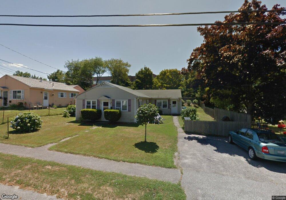
7 Buck Rd Middletown, RI 02842
Estimated Value: $440,746 - $550,000
4
Beds
2
Baths
1,426
Sq Ft
$352/Sq Ft
Est. Value
About This Home
This home is located at 7 Buck Rd, Middletown, RI 02842 and is currently estimated at $501,437, approximately $351 per square foot. 7 Buck Rd is a home located in Newport County with nearby schools including Middletown High School, All Saints STEAM Academy, and The Pennfield School.
Ownership History
Date
Name
Owned For
Owner Type
Purchase Details
Closed on
Jan 21, 1999
Sold by
Guerrera Donald M and Guerrera Maureen
Bought by
Sirois Theresa M
Current Estimated Value
Home Financials for this Owner
Home Financials are based on the most recent Mortgage that was taken out on this home.
Original Mortgage
$71,250
Outstanding Balance
$16,073
Interest Rate
6.7%
Estimated Equity
$485,364
Create a Home Valuation Report for This Property
The Home Valuation Report is an in-depth analysis detailing your home's value as well as a comparison with similar homes in the area
Home Values in the Area
Average Home Value in this Area
Purchase History
| Date | Buyer | Sale Price | Title Company |
|---|---|---|---|
| Sirois Theresa M | $75,000 | -- |
Source: Public Records
Mortgage History
| Date | Status | Borrower | Loan Amount |
|---|---|---|---|
| Open | Sirois Theresa M | $71,250 |
Source: Public Records
Tax History
| Year | Tax Paid | Tax Assessment Tax Assessment Total Assessment is a certain percentage of the fair market value that is determined by local assessors to be the total taxable value of land and additions on the property. | Land | Improvement |
|---|---|---|---|---|
| 2025 | $4,128 | $350,100 | $153,500 | $196,600 |
| 2024 | $3,942 | $350,100 | $153,500 | $196,600 |
| 2023 | $2,727 | $216,600 | $99,000 | $117,600 |
| 2022 | $2,604 | $216,600 | $99,000 | $117,600 |
| 2021 | $2,604 | $216,600 | $99,000 | $117,600 |
| 2020 | $2,663 | $193,500 | $86,100 | $107,400 |
| 2018 | $2,661 | $193,500 | $86,100 | $107,400 |
| 2016 | $2,629 | $170,500 | $73,900 | $96,600 |
| 2015 | $2,564 | $170,500 | $73,900 | $96,600 |
| 2014 | $2,795 | $173,900 | $80,600 | $93,300 |
| 2013 | $2,732 | $173,900 | $80,600 | $93,300 |
Source: Public Records
Map
Nearby Homes
- 3 Wabasso Terrace
- 8 Wabasso Terrace
- 74 Valley Rd
- 533 Forest Park
- 662 Forest Park
- 743 Forest Park
- 738 Forest Avenue Mobile Home Park
- 836 Forest Park
- 502 Forest Rd
- 719 Forest Park
- 599 E Main Rd
- 136 Corporate Place
- 4 Halsey Ave
- 51 Smythe St
- 22 Connecticut Ave
- 16 Ward Ave
- 314 Chases Ln Unit C
- 55 Mixter St
- 149 W Main Rd
- 403 Valley Rd
Your Personal Tour Guide
Ask me questions while you tour the home.