Estimated Value: $569,224 - $658,000
2
Beds
2
Baths
1,312
Sq Ft
$476/Sq Ft
Est. Value
About This Home
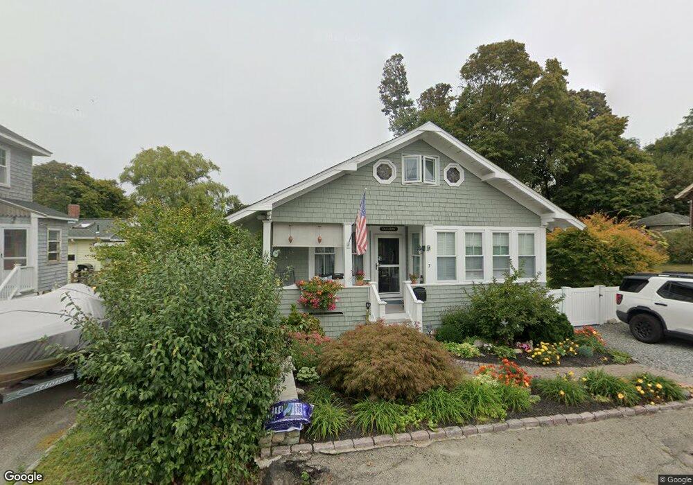
This home is located at 7 Maple Way, Hull, MA 02045 and is currently estimated at $624,556, approximately $476 per square foot. 7 Maple Way is a home located in Plymouth County with nearby schools including Lillian M. Jacobs Elementary School, Memorial Middle School, and Hull High School.
Ownership History
Date
Name
Owned For
Owner Type
Purchase Details
Closed on
May 15, 2003
Sold by
Brooks Kenneth R and Brooks Maria S
Bought by
Gleason Michael P and Gleason Marjorie R
Current Estimated Value
Purchase Details
Closed on
Aug 25, 1989
Sold by
Hull Fed Cr Un
Bought by
Mccarthy Paul M
Purchase Details
Closed on
Jun 23, 1989
Sold by
Corcoran Robert F
Bought by
Hull Fed Credit Union
Create a Home Valuation Report for This Property
The Home Valuation Report is an in-depth analysis detailing your home's value as well as a comparison with similar homes in the area
Purchase History
| Date | Buyer | Sale Price | Title Company |
|---|---|---|---|
| Gleason Michael P | $299,900 | -- | |
| Mccarthy Paul M | $106,850 | -- | |
| Hull Fed Credit Union | $100,000 | -- |
Source: Public Records
Mortgage History
| Date | Status | Borrower | Loan Amount |
|---|---|---|---|
| Open | Hull Fed Credit Union | $34,500 | |
| Open | Hull Fed Credit Union | $238,986 |
Source: Public Records
Tax History
| Year | Tax Paid | Tax Assessment Tax Assessment Total Assessment is a certain percentage of the fair market value that is determined by local assessors to be the total taxable value of land and additions on the property. | Land | Improvement |
|---|---|---|---|---|
| 2025 | $5,590 | $499,100 | $182,700 | $316,400 |
| 2024 | $5,477 | $470,100 | $176,400 | $293,700 |
| 2023 | $5,344 | $439,100 | $163,800 | $275,300 |
| 2022 | $4,945 | $394,300 | $151,200 | $243,100 |
| 2021 | $4,878 | $384,700 | $144,900 | $239,800 |
| 2020 | $4,577 | $357,000 | $144,900 | $212,100 |
| 2019 | $4,378 | $335,500 | $138,600 | $196,900 |
| 2018 | $4,156 | $309,700 | $138,600 | $171,100 |
| 2017 | $3,869 | $282,000 | $126,000 | $156,000 |
| 2016 | $3,801 | $282,000 | $126,000 | $156,000 |
| 2015 | $3,615 | $259,300 | $107,100 | $152,200 |
| 2014 | $3,451 | $248,800 | $107,100 | $141,700 |
Source: Public Records
Map
Nearby Homes
- 18 Valley Beach Ave
- 9 Meade Ave Unit 1
- 0 Seaview Ave
- 6 State Park Rd Unit 2
- 37 Richards Rd Unit A
- 37 Richards Rd
- 1 Longbeach Ave Unit 202
- 62 Oceanside Dr
- 99 Nantasket Ave
- 181 Atlantic Ave
- 6 Montana Ave
- 120 Nantasket Ave Unit 207
- 120 Nantasket Ave Unit 204
- 120 Nantasket Ave Unit 304
- 120 Nantasket Ave Unit PH5
- 120 Nantasket Ave Unit 201
- 121 Nantasket Ave Unit 503
- 10 Berkley Rd Unit A
- 23 Wyola Rd
- 9 Park Ave Unit 202
- 20 Valley Beach Ave
- 9 Maple Way
- 22-r Valley Beach Ave
- 22 Valley Beach Ave
- 10 Maple Way
- 16 Valley Beach Ave
- 6 Maple Way
- 9 Maple Ln
- 9 Maple Ln Unit $4.5k-8.25k
- 9 Maple Ln Unit $4.5k-8.25k
- 9 Maple Ln Unit house
- 9 Maple Ln Unit B
- 9B Maple Ln
- 9A Maple Ln
- 14 Valley Beach Ave
- 242 Atlantic Ave
- 242 Atlantic Ave Unit 2
- 248 Atlantic Ave
- 28 Valley Beach Ave
- 248 Atlantic Avenue (Year Round) Unit 2
Your Personal Tour Guide
Ask me questions while you tour the home.