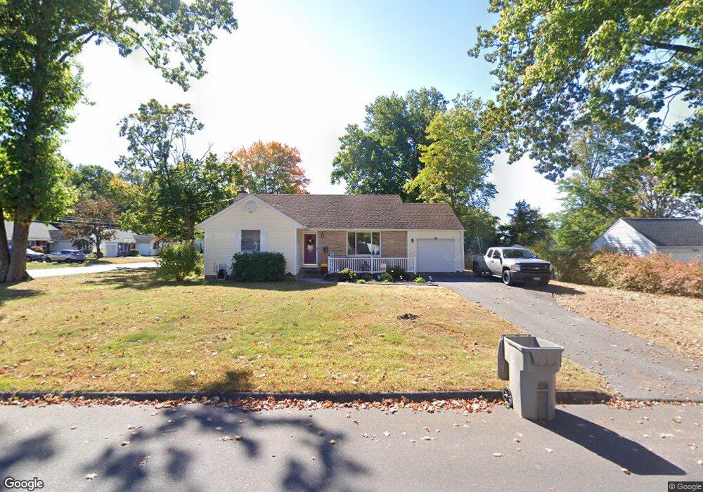
70 Paul St Bristol, CT 06010
Forestville NeighborhoodEstimated Value: $262,000 - $329,000
3
Beds
1
Bath
1,148
Sq Ft
$267/Sq Ft
Est. Value
About This Home
This home is located at 70 Paul St, Bristol, CT 06010 and is currently estimated at $306,960, approximately $267 per square foot. 70 Paul St is a home located in Hartford County with nearby schools including Northeast Middle School, Bristol Eastern High School, and St Matthew School.
Ownership History
Date
Name
Owned For
Owner Type
Purchase Details
Closed on
Apr 1, 1998
Sold by
Fleet Mtg Corp
Bought by
Bernier Thomas P and Bernier Karen J
Current Estimated Value
Purchase Details
Closed on
May 9, 1997
Sold by
Links Doris
Bought by
Stamatelos Richard
Purchase Details
Closed on
Sep 24, 1987
Sold by
Patten Frank C
Bought by
Swanson Ronald W
Create a Home Valuation Report for This Property
The Home Valuation Report is an in-depth analysis detailing your home's value as well as a comparison with similar homes in the area
Home Values in the Area
Average Home Value in this Area
Purchase History
We collect this data history from publicly available records. To have your information removed, we recommend requesting removal directly through your county’s website.
| Date | Buyer | Sale Price | Title Company |
|---|---|---|---|
| Bernier Thomas P | $75,000 | -- | |
| Stamatelos Richard | $112,000 | -- | |
| Swanson Ronald W | $128,000 | -- |
Source: Public Records
Mortgage History
We collect this data history from publicly available records. To have your information removed, we recommend requesting removal directly through your county’s website.
| Date | Status | Borrower | Loan Amount |
|---|---|---|---|
| Closed | Swanson Ronald W | $7,600 | |
| Open | Swanson Ronald W | $157,800 |
Source: Public Records
Tax History
| Year | Tax Paid | Tax Assessment Tax Assessment Total Assessment is a certain percentage of the fair market value that is determined by local assessors to be the total taxable value of land and additions on the property. | Land | Improvement |
|---|---|---|---|---|
| 2025 | $4,928 | $146,020 | $39,270 | $106,750 |
| 2024 | $4,651 | $146,020 | $39,270 | $106,750 |
| 2023 | $4,432 | $146,020 | $39,270 | $106,750 |
| 2022 | $3,952 | $103,040 | $31,850 | $71,190 |
| 2021 | $3,952 | $103,040 | $31,850 | $71,190 |
| 2020 | $3,952 | $103,040 | $31,850 | $71,190 |
| 2019 | $3,921 | $103,040 | $31,850 | $71,190 |
| 2018 | $3,800 | $103,040 | $31,850 | $71,190 |
| 2017 | $3,816 | $105,910 | $39,620 | $66,290 |
| 2016 | $3,816 | $105,910 | $39,620 | $66,290 |
| 2015 | $3,666 | $105,910 | $39,620 | $66,290 |
| 2014 | $3,666 | $105,910 | $39,620 | $66,290 |
Source: Public Records
Map
Nearby Homes
- 69 Constance Ln
- 14 Hotchkiss Dr
- 132 Milton Rd
- 578 Camp St
- 12 Overlook Dr
- 0 Overlook Dr Unit Lots 3 and 4
- 2 Burton St
- 159 Robertson St
- 108 Georgetown Rd
- 513 Stafford Ave
- 35 Buckley Ave
- 1325 Farmington Ave Unit 52
- 1325 Farmington Ave Unit 1
- 1325 Farmington Ave Unit 13
- 63 Songbird Ln
- 1469 Farmington Ave Unit 55
- 8 Winchester Ct Unit 8
- 137 Brook St
- 428 Washington St
- 42 Sandy Dr
Your Personal Tour Guide
Ask me questions while you tour the home.