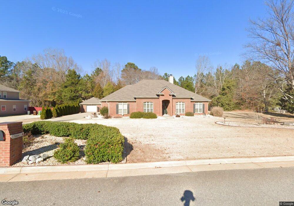
7004 Daniel Ct Upatoi, GA 31829
Estimated Value: $409,000 - $458,758
4
Beds
4
Baths
2,771
Sq Ft
$156/Sq Ft
Est. Value
About This Home
This home is located at 7004 Daniel Ct, Upatoi, GA 31829 and is currently estimated at $432,940, approximately $156 per square foot. 7004 Daniel Ct is a home located in Muscogee County with nearby schools including Mathews Elementary School, Aaron Cohn Middle School, and Shaw High School.
Ownership History
Date
Name
Owned For
Owner Type
Purchase Details
Closed on
Oct 11, 2007
Sold by
Parrish Construction Co In
Bought by
Wiley Ferrel L and Wiley Barbara F
Current Estimated Value
Home Financials for this Owner
Home Financials are based on the most recent Mortgage that was taken out on this home.
Original Mortgage
$177,500
Interest Rate
6.08%
Mortgage Type
Purchase Money Mortgage
Create a Home Valuation Report for This Property
The Home Valuation Report is an in-depth analysis detailing your home's value as well as a comparison with similar homes in the area
Purchase History
| Date | Buyer | Sale Price | Title Company |
|---|---|---|---|
| Wiley Ferrel L | $312,000 | -- | |
| Wiley Ferrel K | $312,000 | None Available |
Source: Public Records
Mortgage History
| Date | Status | Borrower | Loan Amount |
|---|---|---|---|
| Closed | Wiley Ferrel K | $177,500 |
Source: Public Records
Tax History
| Year | Tax Paid | Tax Assessment Tax Assessment Total Assessment is a certain percentage of the fair market value that is determined by local assessors to be the total taxable value of land and additions on the property. | Land | Improvement |
|---|---|---|---|---|
| 2025 | $4,126 | $188,332 | $17,068 | $171,264 |
| 2024 | $412 | $188,332 | $17,068 | $171,264 |
| 2023 | $2,141 | $188,332 | $17,068 | $171,264 |
| 2022 | $4,334 | $149,064 | $17,068 | $131,996 |
| 2021 | $4,327 | $123,452 | $17,068 | $106,384 |
| 2020 | $4,328 | $123,452 | $17,068 | $106,384 |
| 2019 | $4,346 | $123,452 | $17,068 | $106,384 |
| 2018 | $4,346 | $134,612 | $17,068 | $117,544 |
| 2017 | $4,364 | $134,612 | $17,068 | $117,544 |
| 2016 | $4,379 | $130,797 | $24,000 | $106,797 |
| 2015 | $4,384 | $130,797 | $24,000 | $106,797 |
| 2014 | $1,893 | $130,797 | $24,000 | $106,797 |
| 2013 | -- | $137,531 | $24,000 | $113,531 |
Source: Public Records
Map
Nearby Homes
- 7798 Mckee Rd
- 7788 Mckee Rd
- 8585 Mckee Rd
- 8705 Mckee Rd
- 7524 Hedgestone Dr
- 68 Wood Duck Ct
- 14270 Cross Creek Rd
- 13965 Cross Creek Rd
- 0 Boyd Ct
- 3450 Mckee Rd
- 13642 Macon Rd
- 7232 Woodhaven Dr
- 561 Abberly Ln
- 18 Claudette Ct
- 31 Boxwood Ct
- Tract 1 - 877 Mckee Rd
- Tract 2 - 877 Mckee Rd
- 877 Mckee Rd
- 66 Timber Loop
- 183 Abberly Ln
- 7005 Daniel Ct
- 7008 Daniel Ct
- 7058 Kendall Creek Dr
- 7003 Daniels Ct
- 7003 Daniel Ct
- 7009 Daniel Ct
- 7012 Daniel Ct
- 7014 Kendall Creek Dr
- 7001 Daniel Ct
- 7010 Kendall Creek Dr
- 7018 Kendall Creek Dr
- 7013 Daniel Ct
- 7006 Kendall Creek Dr
- 7022 Kendall Creek Dr
- 7016 Daniel Ct
- 7055 Kendall Creek Dr
- 7017 Daniel Ct
- 8450 Mckee Rd
- 7015 Kendall Creek Dr
- 7015 Kendall Creek Dr Unit 80
Your Personal Tour Guide
Ask me questions while you tour the home.