702 S Oakhurst Ct Huron, OH 44839
Huron AreaEstimated Value: $347,000 - $380,000
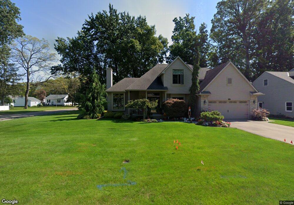
About This Home
This home is located at 702 S Oakhurst Ct, Huron, OH 44839 and is currently estimated at $367,298, approximately $188 per square foot. 702 S Oakhurst Ct is a home located in Erie County with nearby schools including Shawnee Elementary School, Woodlands Intermediate School, and McCormick Junior High School.
Ownership History
We collect this data history from publicly available records. To have your information removed, we recommend requesting removal directly through your county’s website.
Purchase Details
Home Values in the Area
Average Home Value in this Area
Purchase History
We collect this data history from publicly available records. To have your information removed, we recommend requesting removal directly through your county’s website.
| Date | Buyer | Sale Price | Title Company |
|---|---|---|---|
| $171,000 | -- |
Tax History
We collect this data history from publicly available records. To have your information removed, we recommend requesting removal directly through your county’s website.
| Year | Tax Paid | Tax Assessment Tax Assessment Total Assessment is a certain percentage of the fair market value that is determined by local assessors to be the total taxable value of land and additions on the property. | Land | Improvement |
|---|---|---|---|---|
| 2025 | $4,004 | $107,649 | $14,346 | $93,303 |
| 2024 | $4,165 | $107,649 | $14,346 | $93,303 |
| 2023 | $4,278 | $75,288 | $12,614 | $62,674 |
| 2022 | $3,120 | $75,285 | $12,614 | $62,671 |
| 2021 | $3,112 | $75,280 | $12,610 | $62,670 |
| 2020 | $2,915 | $68,700 | $12,610 | $56,090 |
| 2019 | $3,043 | $68,700 | $12,610 | $56,090 |
| 2018 | $3,059 | $68,700 | $12,610 | $56,090 |
| 2017 | $3,039 | $66,320 | $10,720 | $55,600 |
| 2016 | $2,942 | $66,320 | $10,720 | $55,600 |
| 2015 | $2,938 | $66,320 | $10,720 | $55,600 |
| 2014 | $2,973 | $66,320 | $10,720 | $55,600 |
| 2013 | $2,930 | $66,320 | $10,720 | $55,600 |
Map
- 547 Wilder Ave
- 810 Taylor Ave
- 411 Wilbor Ave
- 328 Brunswick Dr
- 301 Willow Dr
- 11 Turtle Bay
- 305 Forest Hills Dr
- 823 Gloucester Dr
- 115 Turtle Bay Unit 115
- 346 Main St
- 4075 Coventry Cir
- 28 Turtle Bay
- 1020 Main St
- 404 Leisure Dr Unit 404
- 305 Concord Ct
- 1 Cleveland Rd W
- 403 Rivers Edge Dr Unit 403
- 937 Ridgeview Dr
- 1114 Mudbrook Rd
- 303 Canterbury Dr
- 633 Taylor Ave
- 629 Taylor Ave
- 637 Taylor Ave
- 620 N Oakhurst Ct
- 625 Taylor Ave
- 618 N Oakhurst Ct
- 634 Taylor Ave
- 634 Taylor Ave
- 703 Taylor Ave
- 616 N Oakhurst Ct
- 630 Taylor Ave
- 638 Taylor Ave
- 626 Taylor Ave
- 606 Adams Ave
- 705 Taylor Ave
- 568 Wilbor Ave
- 614 N Oakhurst Ct
- 604 Adams Ave
- 619 N Oakhurst Ct
- 621 N Oakhurst Ct
Ask me questions while you tour the home.