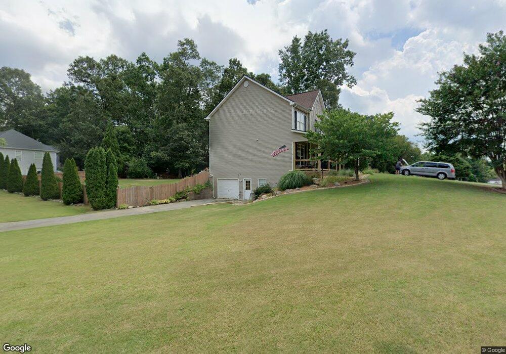
707 Bedford Trace Canton, GA 30114
Estimated Value: $421,166 - $443,000
4
Beds
3
Baths
2,310
Sq Ft
$187/Sq Ft
Est. Value
About This Home
This home is located at 707 Bedford Trace, Canton, GA 30114 and is currently estimated at $432,083, approximately $187 per square foot. 707 Bedford Trace is a home located in Cherokee County with nearby schools including J. Knox Elementary School, Teasley Middle School, and Cherokee High School.
Ownership History
Date
Name
Owned For
Owner Type
Purchase Details
Closed on
Nov 13, 2008
Sold by
Federal Natl Mtg Assn Fnma
Bought by
Pentz Bernadette
Current Estimated Value
Home Financials for this Owner
Home Financials are based on the most recent Mortgage that was taken out on this home.
Original Mortgage
$152,000
Outstanding Balance
$99,016
Interest Rate
6.01%
Mortgage Type
New Conventional
Estimated Equity
$333,067
Purchase Details
Closed on
Aug 5, 2008
Sold by
Countrywide Hm Lns Inc
Bought by
Federal Natl Mtg Assn Fnma
Purchase Details
Closed on
Jun 25, 2001
Sold by
Cronan Michael G
Bought by
Fair Robert L and Fair Laura L
Home Financials for this Owner
Home Financials are based on the most recent Mortgage that was taken out on this home.
Original Mortgage
$171,700
Interest Rate
6.97%
Mortgage Type
New Conventional
Create a Home Valuation Report for This Property
The Home Valuation Report is an in-depth analysis detailing your home's value as well as a comparison with similar homes in the area
Home Values in the Area
Average Home Value in this Area
Purchase History
We collect this data history from publicly available records. To have your information removed, we recommend requesting removal directly through your county’s website.
| Date | Buyer | Sale Price | Title Company |
|---|---|---|---|
| Pentz Bernadette | -- | -- | |
| Federal Natl Mtg Assn Fnma | -- | -- | |
| Countrywide Hm Lns Inc | $204,385 | -- | |
| Fair Robert L | $214,700 | -- |
Source: Public Records
Mortgage History
We collect this data history from publicly available records. To have your information removed, we recommend requesting removal directly through your county’s website.
| Date | Status | Borrower | Loan Amount |
|---|---|---|---|
| Open | Pentz Bernadette | $152,000 | |
| Previous Owner | Fair Robert L | $171,700 |
Source: Public Records
Tax History
| Year | Tax Paid | Tax Assessment Tax Assessment Total Assessment is a certain percentage of the fair market value that is determined by local assessors to be the total taxable value of land and additions on the property. | Land | Improvement |
|---|---|---|---|---|
| 2025 | $3,917 | $170,280 | $34,000 | $136,280 |
| 2024 | $3,838 | $167,392 | $34,000 | $133,392 |
| 2023 | $3,482 | $171,152 | $34,000 | $137,152 |
| 2022 | $3,190 | $134,800 | $26,000 | $108,800 |
| 2021 | $2,982 | $114,320 | $22,400 | $91,920 |
| 2020 | $2,731 | $103,400 | $20,000 | $83,400 |
| 2019 | $2,702 | $102,160 | $20,000 | $82,160 |
| 2018 | $2,563 | $95,640 | $14,800 | $80,840 |
| 2017 | $2,282 | $207,000 | $14,800 | $68,000 |
| 2016 | $2,292 | $205,800 | $14,800 | $67,520 |
| 2015 | $2,306 | $204,900 | $14,800 | $67,160 |
| 2014 | $2,122 | $185,800 | $14,800 | $59,520 |
Source: Public Records
Map
Nearby Homes
- 902 Cobblestone Trail Unit 3
- 116 Copper Hills Dr
- 405 Trumpet Cir
- 211 Montana Way
- 304 Grant Ct
- 302 Grant Ct
- 305 Blake Dr Unit 1
- 100 Copper Hills Dr
- 308 Saddle Wood Dr
- 320 River Green Ave
- 208 Westbury Ct
- 237 Lusk Ct
- 708 Woodlake Ct
- 1221 Lakeside Overlook
- 251 Fields Landing Dr
- 421 Lusk Ct
- 4966 Millwood Dr
- 845 Lakemont Dr
- 844 Lakemont Dr
- 534 Oriole Farm Trail
- 705 Bedford Trace Unit 3
- 709 Bedford Trace Unit 3
- 712 Bedford Trace
- 716 Bedford Trace
- 800 Kensington Ct Unit 3
- 703 Bedford Trace
- 708 Bedford Trace
- 706 Bedford Trace Unit 3
- 802 Kensington Ct Unit 3
- 711 Bedford Trace
- 711 Bedford Trace Unit 63
- 1110 Fieldstone Dr
- 803 Kensington Ct Unit 3
- 718 Bedford Trace
- 704 Bedford Trace
- 701 Bedford Trace Unit 3
- 720 Bedford Trace
- 1112 Fieldstone Dr Unit 3
- 702 Bedford Trace
- 805 Kensington Ct
Your Personal Tour Guide
Ask me questions while you tour the home.