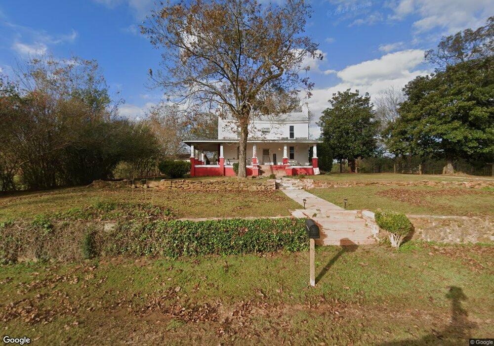
708 Stovall Rd Lagrange, GA 30241
Estimated Value: $382,000 - $602,561
4
Beds
2
Baths
1,852
Sq Ft
$251/Sq Ft
Est. Value
About This Home
This home is located at 708 Stovall Rd, Lagrange, GA 30241 and is currently estimated at $464,520, approximately $250 per square foot. 708 Stovall Rd is a home located in Troup County with nearby schools including Rosemont Elementary School, Whitesville Road Elementary School, and Berta Weathersbee Elementary School.
Ownership History
Date
Name
Owned For
Owner Type
Purchase Details
Closed on
Mar 21, 2024
Sold by
Whitlow Janelle C
Bought by
Whitlow William C
Current Estimated Value
Purchase Details
Closed on
Mar 25, 1994
Sold by
Whitlow William C Jr Int
Bought by
Whitlow William C and Whitlow Janelle
Purchase Details
Closed on
Dec 9, 1993
Sold by
Whitlow William C and Hunt Marie
Bought by
Whitlow William C Jr Int
Purchase Details
Closed on
Jan 1, 1901
Sold by
Georgia Better Farms #18
Bought by
Whitlow William C and Hunt Marie
Create a Home Valuation Report for This Property
The Home Valuation Report is an in-depth analysis detailing your home's value as well as a comparison with similar homes in the area
Purchase History
| Date | Buyer | Sale Price | Title Company |
|---|---|---|---|
| Whitlow William C | -- | -- | |
| Whitlow William C | -- | -- | |
| Whitlow William C | -- | -- | |
| Whitlow William C Jr Int | $200,000 | -- | |
| Whitlow William C | -- | -- |
Source: Public Records
Tax History
| Year | Tax Paid | Tax Assessment Tax Assessment Total Assessment is a certain percentage of the fair market value that is determined by local assessors to be the total taxable value of land and additions on the property. | Land | Improvement |
|---|---|---|---|---|
| 2025 | $2,050 | $174,800 | $135,240 | $39,560 |
| 2024 | $4,489 | $164,580 | $135,240 | $29,340 |
| 2023 | $1,632 | $172,900 | $149,240 | $23,660 |
| 2022 | $1,547 | $144,300 | $123,480 | $20,820 |
| 2021 | $1,484 | $124,744 | $108,240 | $16,504 |
| 2020 | $1,458 | $124,744 | $108,240 | $16,504 |
| 2019 | $1,435 | $124,824 | $108,240 | $16,584 |
| 2018 | $1,374 | $123,620 | $108,240 | $15,380 |
| 2017 | $1,350 | $123,620 | $108,240 | $15,380 |
| 2016 | $1,306 | $122,938 | $108,301 | $14,637 |
| 2015 | $1,285 | $122,938 | $108,301 | $14,637 |
| 2014 | $1,242 | $122,168 | $108,301 | $13,867 |
| 2013 | -- | $122,380 | $108,150 | $14,230 |
Source: Public Records
Map
Nearby Homes
- 37.23 ACRES / 0 Smokey Rd
- 0 Smokey Rd Unit 10570471
- 0 Briley Rd Unit 10582531
- 0 Briley Rd Unit 214353
- 0 Lower Big Springs Rd Unit 10718109
- 0 Lower Big Springs Rd Unit 26695797
- 829 Thrash Rd
- 950 John Lovelace Rd
- 830 John Lovelace Rd
- 120 Greenbriar Trail
- 0 Wadley St Unit 10709450
- 0 Wadley St Unit 27032785
- 476 Thrash Rd
- 111 Prestwick Dr
- 23 Nantucket Dr
- 137 Robertson Rd
- 112 Greenbriar Trail
- 53 Nantucket Dr
- 123 S Smith Rd
- 246 S Smith Rd
Your Personal Tour Guide
Ask me questions while you tour the home.