

7106 Long Rd Show Low, AZ 85901
Estimated payment $7,637/month
Total Views
45,280
7
Beds
5
Baths
4,500
Sq Ft
$300
Price per Sq Ft
Highlights
- Horses Allowed On Property
- 3.55 Acre Lot
- Wood Burning Stove
- Linden Elementary School Rated A-
- Deck
- Freestanding Bathtub
About This Home
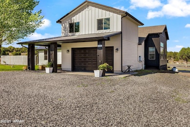
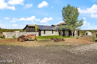
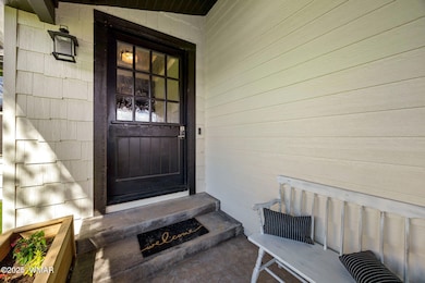
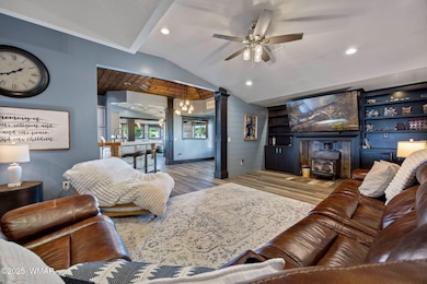
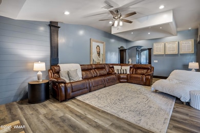
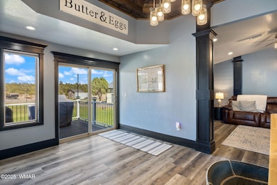
This stunning modern farmhouse blends rustic character with refined design, offering the perfect balance of comfort and style. From the moment you arrive, you'll notice the striking exterior with bold black trim, light siding, and solar panels for energy efficiency.Inside, an open floor plan showcases custom finishes throughout. The gourmet kitchen features a butcher block breakfast bar, granite countertops, distressed metal backsplash, and T&G wood ceiling opening to the spacious living room with built-in cabinetry, wood-burning stove, and warm natural light. The adjoining dining area is ideal for family gatherings and entertaining.The primary suite is a true retreat with a spa-inspired bath, including a freestanding soaking tub, walk-in shower
Listing Agent
Keller Williams Realty Phoenix - Show Low License #SA681849000 Listed on: 10/23/2025
Home Details
Home Type
- Single Family
Est. Annual Taxes
- $3,966
Year Built
- Built in 2009
Lot Details
- 3.55 Acre Lot
- Landscaped with Trees
Home Design
- Wood Frame Construction
- Pitched Roof
- Shingle Roof
- Metal Roof
Interior Spaces
- 4,500 Sq Ft Home
- Wood Burning Stove
- Breakfast Room
- Combination Kitchen and Dining Room
- Utility Room
Kitchen
- Double Oven
- Gas Range
- Microwave
- Disposal
Flooring
- Tile
- Vinyl Plank
- Vinyl
Bedrooms and Bathrooms
- 7 Bedrooms
- Possible Extra Bedroom
- In-Law or Guest Suite
- 5 Bathrooms
- Freestanding Bathtub
- Soaking Tub
- Shower Only
Parking
- 4 Garage Spaces | 2 Attached and 2 Detached
- Garage Door Opener
Utilities
- Forced Air Heating System
- Separate Meters
- Private Company Owned Well
Additional Features
- Solar owned by seller
- Deck
- Separate Entry Quarters
- Horses Allowed On Property
Community Details
- No Home Owners Association
Listing and Financial Details
- Assessor Parcel Number 205-35-061C
Map
Create a Home Valuation Report for This Property
The Home Valuation Report is an in-depth analysis detailing your home's value as well as a comparison with similar homes in the area
Home Values in the Area
Average Home Value in this Area
Tax History
| Year | Tax Paid | Tax Assessment Tax Assessment Total Assessment is a certain percentage of the fair market value that is determined by local assessors to be the total taxable value of land and additions on the property. | Land | Improvement |
|---|---|---|---|---|
| 2026 | $3,966 | -- | -- | -- |
| 2025 | $3,916 | $91,563 | $16,761 | $74,802 |
| 2024 | $3,682 | $94,208 | $20,710 | $73,498 |
| 2023 | $3,916 | $71,834 | $11,898 | $59,936 |
| 2022 | $3,682 | $0 | $0 | $0 |
| 2021 | $3,728 | $0 | $0 | $0 |
| 2020 | $2,510 | $0 | $0 | $0 |
| 2019 | $2,512 | $0 | $0 | $0 |
| 2018 | $2,380 | $0 | $0 | $0 |
| 2017 | $2,081 | $0 | $0 | $0 |
Source: Public Records
Property History
| Date | Event | Price | List to Sale | Price per Sq Ft |
|---|---|---|---|---|
| 10/23/2025 10/23/25 | For Sale | $1,350,000 | -- | $300 / Sq Ft |
Source: White Mountain Association of REALTORS®
Purchase History
We collect this data history from publicly available records. To have your information removed, we recommend requesting removal directly through your county’s website.
| Date | Type | Sale Price | Title Company |
|---|---|---|---|
| Quit Claim Deed | -- | Riggs Ellsworth & Porter Plc | |
| Quit Claim Deed | -- | Riggs Ellsworth & Porter Plc | |
| Quit Claim Deed | -- | Riggs Ellsworth & Porter Plc | |
| Interfamily Deed Transfer | -- | None Available | |
| Quit Claim Deed | -- | None Available | |
| Quit Claim Deed | -- | None Available |
Source: Public Records
About the Listing Agent
Luxury Expert - White Mountains of Arizona
Welcome to the White Mountains of Arizona! I specialize in the Show Low, Pinetop, Lakeside and White Mountain area. Living in the White Mountains is a lifestyle choice. No matter what your real estate needs my team and I can help you navigate the process. Our area is a second home market by nature which requires local expertise and market knowledge to keep more of your money in your pocket. Our team has that experience and is the top rated team in
Joseph's Other Listings
Source: White Mountain Association of REALTORS®
MLS Number: 258408
APN: 205-35-061C
Disclaimer: Certain information contained herein is derived from information provided by parties other than Homes.com. All information provided is deemed reliable, but is not guaranteed to be accurate and should be independently verified.
![]() Copyright 2026. Listing data deemed reliable but not guaranteed.
Copyright 2026. Listing data deemed reliable but not guaranteed.
Nearby Homes
- 1276 Lone Pine Dam Rd
- 1254 Lone Pine Dam Rd
- 7070 White Gate Way
- 7075 Bryant Blvd
- 7092 Shilo Trail
- 7018 Shilo Trail
- 7025 Dusty Saddle Trail
- 7046 Stagecoach Pass
- 7124 Simons Way
- 7032 Stagecoach Pass
- 7022 Kims Way
- 1107 Cochran Ln
- 1087 Rim View Dr
- 1075 Rim View Dr
- 6923 Laura's Place
- 1053 Lone Pine Dam Rd Unit FS13
- 1108 Pearce Rd
- 1139 Sapphire
- 1009 Chaparral Dr
- 1010 Chaparral Dr
- 4760 W Bison Ln
- 1561 N Mustang Run
- 4680 W Mogollon Dr
- 481 S Yarrow Ln Unit SI ID1255454P
- 3350 W Sugar Pine Way Unit 102
- 950 S Spirea Ln
- 311 S 16th St Unit SI ID1385951P
- 3001 W Young
- 841 S 11th Dr
- 561 N 10th Place
- 561 N 10th Place Unit 103
- 1351 W Sierra Buena Ct
- 760 S Creekside Dr
- 2700 S White Mountain Rd Unit 823
- 2700 S White Mountain Rd
- 2700 S White Mountain #102 Rd Unit 102
- 2800 S White Mountain Rd
- 2800 S White Mountain Rd Unit 84
- 6144 E Starlight Ridge Pkwy
- 3060 E Show Low Lake Rd
Your Personal Tour Guide
Ask me questions while you tour the home.