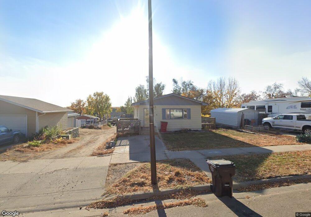
715 W Capitol Ave Pierre, SD 57501
Estimated Value: $145,535 - $212,000
2
Beds
1
Bath
960
Sq Ft
$198/Sq Ft
Est. Value
About This Home
This home is located at 715 W Capitol Ave, Pierre, SD 57501 and is currently estimated at $189,634, approximately $197 per square foot. 715 W Capitol Ave is a home with nearby schools including T.F. Riggs High School and Pierre SDA School.
Ownership History
Date
Name
Owned For
Owner Type
Purchase Details
Closed on
Jun 1, 2007
Sold by
Nielsen Angela M
Bought by
Nicholls Leanne
Current Estimated Value
Home Financials for this Owner
Home Financials are based on the most recent Mortgage that was taken out on this home.
Original Mortgage
$100,510
Outstanding Balance
$62,099
Interest Rate
6.37%
Estimated Equity
$127,535
Create a Home Valuation Report for This Property
The Home Valuation Report is an in-depth analysis detailing your home's value as well as a comparison with similar homes in the area
Home Values in the Area
Average Home Value in this Area
Purchase History
| Date | Buyer | Sale Price | Title Company |
|---|---|---|---|
| Nicholls Leanne | $95,500 | -- |
Source: Public Records
Mortgage History
| Date | Status | Borrower | Loan Amount |
|---|---|---|---|
| Open | Nicholls Leanne | $100,510 |
Source: Public Records
Tax History
| Year | Tax Paid | Tax Assessment Tax Assessment Total Assessment is a certain percentage of the fair market value that is determined by local assessors to be the total taxable value of land and additions on the property. | Land | Improvement |
|---|---|---|---|---|
| 2025 | $1,975 | $165,955 | $37,020 | $128,935 |
| 2024 | $1,969 | $159,815 | $37,020 | $122,795 |
| 2023 | $1,816 | $155,226 | $35,426 | $119,800 |
| 2022 | $1,709 | $133,572 | $33,739 | $99,833 |
| 2021 | $1,674 | $119,261 | $30,124 | $89,137 |
| 2020 | $1,714 | $115,788 | $29,247 | $86,541 |
| 2019 | $1,711 | $115,788 | $29,247 | $86,541 |
| 2018 | $1,639 | $112,415 | $28,395 | $84,020 |
| 2017 | -- | $107,062 | $27,043 | $80,019 |
| 2016 | $1,715 | $107,062 | $27,043 | $80,019 |
| 2015 | -- | $103,943 | $26,255 | $77,688 |
| 2014 | -- | $100,915 | $25,490 | $75,425 |
| 2013 | -- | $100,915 | $25,490 | $75,425 |
| 2011 | -- | $85,405 | $25,490 | $59,915 |
Source: Public Records
Map
Nearby Homes
- 500 W Pleasant Dr
- 109 S Oneida Ave
- 712 W Prospect Ave
- 418 W Pleasant Dr
- 324 W Pleasant Dr
- 1020 W Capitol Ave
- 110 N Yankton Ave
- 814 W 3rd St
- 523 N Huron Ave
- 814 N Harney Ct
- 100 Terri Ln
- 101 #15 W Prospect
- 703 N Huron Ave
- 330 N Grand Ave
- 124 W Missouri Ave
- 107 E Wynoka St
- 1313 Edgewater Dr
- 219 N Highland Ave
- 338 N Highland Ave
- 302 E Wynoka St
- 719 W Capitol Ave
- 108 S Maple Ave
- 705 W Capitol Ave Unit Capitol
- 107 S Willow Ave
- 712 W Capitol Ave
- 109 S Willow Ave
- 710 W Capitol Ave
- 108 N Maple Ave
- 704 W Capitol Ave
- 103 N Willow Ave
- 115 S Willow Ave
- 802 W Capitol Ave
- 803 W Capitol Ave
- 716 W Pleasant Dr
- 712 W Pleasant Dr
- 708 W Pleasant Dr
- 722 W Pleasant Dr
- 617 W Capitol Ave
- 115 S Maple Ave
- 622 W Capitol Ave
Your Personal Tour Guide
Ask me questions while you tour the home.