717 Westpointe Dr Amherst, OH 44001
Estimated Value: $322,450 - $339,000
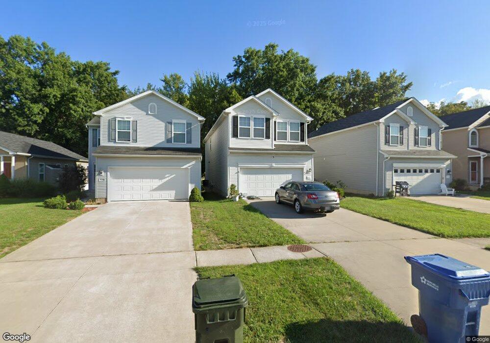
About This Home
This home is located at 717 Westpointe Dr, Amherst, OH 44001 and is currently estimated at $333,113, approximately $144 per square foot. 717 Westpointe Dr is a home with nearby schools including Powers Elementary School, Walter G. Nord Middle School, and Amherst Junior High School.
Ownership History
We collect this data history from publicly available records. To have your information removed, we recommend requesting removal directly through your county’s website.
Purchase Details
Home Financials for this Owner
Home Financials are based on the most recent Mortgage that was taken out on this home.Purchase Details
Home Values in the Area
Average Home Value in this Area
Purchase History
We collect this data history from publicly available records. To have your information removed, we recommend requesting removal directly through your county’s website.
| Date | Buyer | Sale Price | Title Company |
|---|---|---|---|
| $189,000 | None Available | ||
| $83,500 | True Title Agency Inc |
Mortgage History
We collect this data history from publicly available records. To have your information removed, we recommend requesting removal directly through your county’s website.
| Date | Status | Borrower | Loan Amount |
|---|---|---|---|
| Closed | $176,120 | ||
| Closed | $167,505 |
Tax History
We collect this data history from publicly available records. To have your information removed, we recommend requesting removal directly through your county’s website.
| Year | Tax Paid | Tax Assessment Tax Assessment Total Assessment is a certain percentage of the fair market value that is determined by local assessors to be the total taxable value of land and additions on the property. | Land | Improvement |
|---|---|---|---|---|
| 2024 | $4,205 | $104,136 | $21,263 | $82,873 |
| 2023 | $3,370 | $70,347 | $13,605 | $56,742 |
| 2022 | $3,231 | $70,347 | $13,605 | $56,742 |
| 2021 | $3,239 | $70,347 | $13,605 | $56,742 |
| 2020 | $3,122 | $60,180 | $11,640 | $48,540 |
| 2019 | $3,059 | $60,180 | $11,640 | $48,540 |
| 2018 | $3,075 | $60,180 | $11,640 | $48,540 |
| 2017 | $3,336 | $61,270 | $11,740 | $49,530 |
| 2016 | $3,363 | $61,270 | $11,740 | $49,530 |
| 2015 | $3,344 | $61,270 | $11,740 | $49,530 |
| 2014 | $3,506 | $63,950 | $12,250 | $51,700 |
| 2013 | $554 | $9,800 | $9,800 | $0 |
Map
- 809 Bearing Ct
- 940 Longitude Ln
- 953 Longitude Ln
- 0 Middle Ridge Rd Unit 5213866
- 481 Northpointe Blvd
- V/L Middle Ridge Rd
- 1135 Royal Dr
- 7475 S Dewey Rd
- 481 Shupe Ave
- 120 Ambleside Way
- 320 Broadway St
- 107 Keswick Ct
- 7456 Hidden Glen Dr
- 1031 Park Ave
- 701 Tenney Ave
- 2460 Merriment Dr
- 2458 Merriment Dr
- 2452 Merriment Dr
- 3270 Sandmill Run
- 2446 Merriment Dr
- 713 Westpointe Dr
- 711 Westpointe Dr
- 715 Westpointe Dr
- 707 Westpointe Dr
- 705 Westpointe Dr
- 801 Bearing Ct
- 721 Westpointe Dr
- S/L 257 Bearing Ct
- S/L 257 S/L Bearing Ct
- 800 Bearing Ct
- 803 Bearing Ct
- 723 Westpointe Dr
- 701 Westpointe Dr
- 802 Bearing Ct
- 805 Bearing Ct
- 725 Westpointe Dr
- 743 Westpoint Dr
- 804 Bearing Ct
- 806 Bearing Ct
- 727 Westpointe Dr
Ask me questions while you tour the home.