Estimated Value: $194,147 - $202,000
3
Beds
1
Bath
1,092
Sq Ft
$182/Sq Ft
Est. Value
About This Home
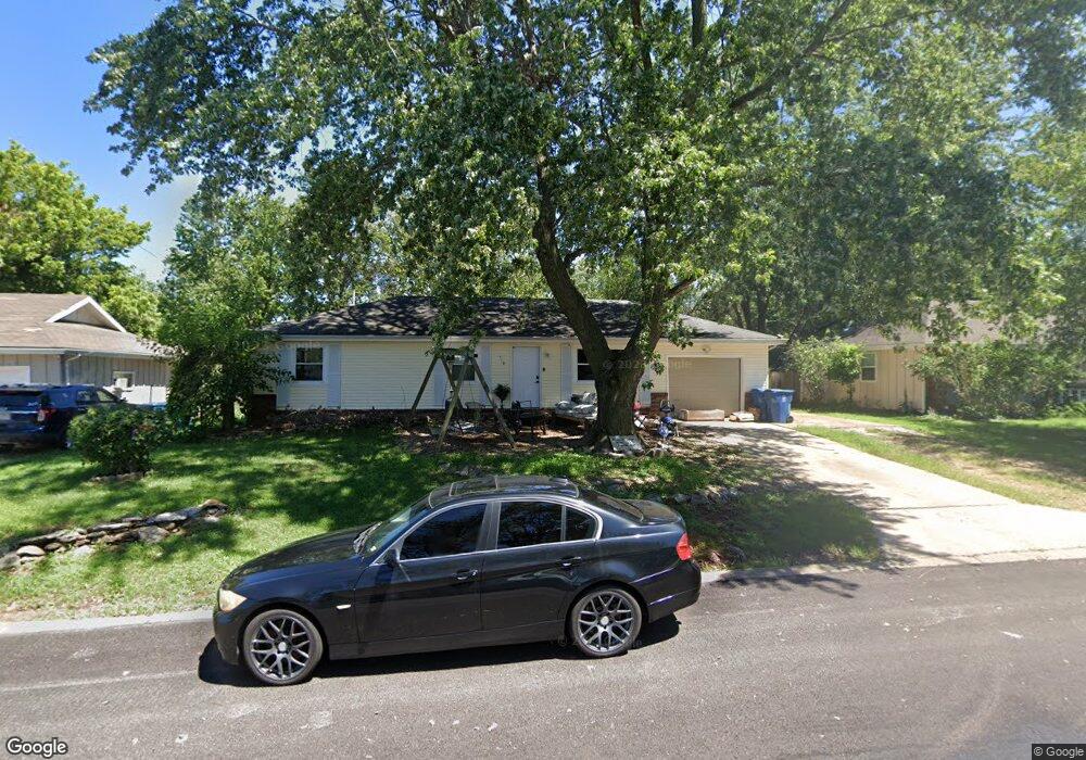
This home is located at 718 Frank St, Nixa, MO 65714 and is currently estimated at $198,537, approximately $181 per square foot. 718 Frank St is a home with nearby schools including Summit Intermediate School, High Pointe Elementary School, and Nixa Junior High School.
Ownership History
Date
Name
Owned For
Owner Type
Purchase Details
Closed on
May 30, 2007
Sold by
Springfield Better Homes Inc
Bought by
Mattar Saul and Mattar Myrna
Current Estimated Value
Home Financials for this Owner
Home Financials are based on the most recent Mortgage that was taken out on this home.
Original Mortgage
$89,500
Outstanding Balance
$53,577
Interest Rate
6.15%
Mortgage Type
New Conventional
Estimated Equity
$144,960
Purchase Details
Closed on
Aug 14, 2006
Sold by
Steele Jami D and Steele Joshua
Bought by
Barnum Delores
Purchase Details
Closed on
Jun 14, 2006
Sold by
Haskill Patricia L and Haskill Jami D
Bought by
Springfield Better Homes Inc
Create a Home Valuation Report for This Property
The Home Valuation Report is an in-depth analysis detailing your home's value as well as a comparison with similar homes in the area
Home Values in the Area
Average Home Value in this Area
Purchase History
We collect this data history from publicly available records. To have your information removed, we recommend requesting removal directly through your county’s website.
| Date | Buyer | Sale Price | Title Company |
|---|---|---|---|
| Mattar Saul | -- | None Available | |
| Barnum Delores | -- | None Available | |
| Springfield Better Homes Inc | $54,271 | None Available |
Source: Public Records
Mortgage History
We collect this data history from publicly available records. To have your information removed, we recommend requesting removal directly through your county’s website.
| Date | Status | Borrower | Loan Amount |
|---|---|---|---|
| Open | Mattar Saul | $89,500 |
Source: Public Records
Tax History
| Year | Tax Paid | Tax Assessment Tax Assessment Total Assessment is a certain percentage of the fair market value that is determined by local assessors to be the total taxable value of land and additions on the property. | Land | Improvement |
|---|---|---|---|---|
| 2025 | $1,001 | $17,370 | -- | -- |
| 2024 | $1,001 | $16,070 | -- | -- |
| 2023 | $1,001 | $16,070 | $0 | $0 |
| 2022 | $884 | $14,170 | $0 | $0 |
| 2021 | $885 | $14,170 | $0 | $0 |
| 2020 | $863 | $13,190 | $0 | $0 |
| 2019 | $863 | $13,190 | $0 | $0 |
| 2018 | $733 | $12,030 | $0 | $0 |
| 2017 | $733 | $12,030 | $0 | $0 |
| 2016 | $722 | $12,030 | $0 | $0 |
| 2015 | $723 | $12,030 | $12,030 | $0 |
| 2014 | $705 | $12,030 | $0 | $0 |
| 2013 | $7 | $12,030 | $0 | $0 |
| 2011 | $7 | $24,060 | $0 | $0 |
Source: Public Records
Map
Nearby Homes
- 212 Raintree St
- 206 E Scott Wayne Dr
- Tbd N Main St
- 714 N Fort St
- 911 Brooke Ct
- 303 Raintree St
- 310 Great Plains St
- 701 Hillcrest Ave
- 311 Northview Rd
- 416 N Prospect St
- 721 Bluegill St
- 1107 N Gretchen St
- Lot 24 the Village of Cloverhill
- Lot 26 the Village of Cloverhill
- 1383 N Maxine Ave
- 1110 N Arlington St
- 708 E Dyann Dr
- Lot 23 the Village of Cloverhill
- 1343 N Maxine Ave
- 316 Hillcrest Ave
Your Personal Tour Guide
Ask me questions while you tour the home.