NOT LISTED FOR SALE

72 E Fork Big Sandy 23-133 Rd Boulder, WY 82923

Estimated Value: $462,000

35 Acres
$13,200 Price per Acre
1,524,600 Sq Ft Lot

Last Sold April 28, 2017

Current estimated payment $2,802/month

1,429 Days on Market

Highlights

  • Horses Allowed On Property
  • Mountain View
  • Open Space
  • 35 Acre Lot
  • No HOA
  • Level Lot

About This Lot

As of April 2017

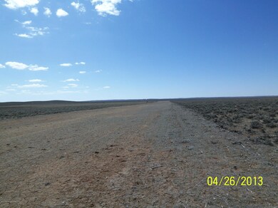
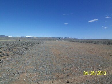
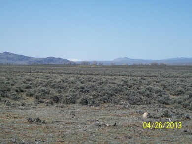
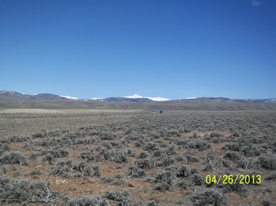
(Goodwin) Private Airstrip Property. 35 acres on a County Road. Access to BLM, USFS, WY State Land, East Fork River, Pocket Creek, and more. Absolutely unbelievable Wind River Mountain Views! Borders BLM to the north and WY State land to the east. Ride your horses right onto Bridger Teton National Forest, across public land, appx 5 mi away. Premier recreation areas nearby. Seller financing possible. The East Fork River, a premier trout fishery, is less than a mile away across public land. Pocket Creek, Irish Canyon, and more is just a bit further. The Wind River Mountains offer hundreds of lakes to fish and limitless miles of hiking as well. Elk Country is just right up the road! You could literally fish almost 10 miles of the East Fork River right up into the forest. This property is partially fenced. Frequented by antelope, deer, and more. The property has its own well, is right off of a Sublette County road, and has a driveway already in place. Electricity is nearby along the County road. Build your dream home, airplane hanger, and more and have ready access from anywhere!

Last Listed By

James Thomas

High Mountain Real Estate License #10364 Listed on: 04/20/2013

Property Details

Property Type

  • Land

Est. Annual Taxes

  • $498

Year Built

  • 2017

Lot Details

  • 35 Acre Lot
  • Open Space
  • Adjoins Government Land
  • Year Round Access
  • Level Lot
  • Zoning described as Agricultural

Utilities

  • Electricity To Lot Line
  • Well
  • Phone Available

Additional Features

  • Mountain Views
  • Horses Allowed On Property

Community Details

  • No Home Owners Association

Listing and Financial Details

  • Assessor Parcel Number 31061710003700

Property Details

Property Type

Land

Est. Annual Taxes

$498

Year Built

2017

Lot Details

0

Listing Details

  • Prop. Type: Building Site
  • Horses: Yes
  • Lot Size Acres: 35.0
  • Lot Size: 35.0 Acres
  • Road Surface Type: Gravel
  • Subdivision Name: None
  • Directions: Hwy 191 S to Boulder. L onto WY 353. Go appx 15.5 mi and R onto 23-133. Prop is appx 0.7 mi on R.
  • Property Info:Horses Allowed: Yes
  • Property Features:Adjacent Open Space: Yes
  • Property Features:Flat: Yes
  • Property Features:Year Round Access: Yes
  • View:Mountain View: Yes
  • Property Info:_pound_ Horses Allowed: 10+
  • Sale Status:Potential Short Sale: No
  • Property Features:Electric to Property: Yes
  • Property Features:Phone to Lot Line: Yes
  • Property Features:Adjacent Pub Land: Yes
  • Special Features: None
  • Property Sub Type: LotsLands
  • Year Built (Public Record): 2017

Exterior Features

  • Lot Features: Year Round Access, Adjacent Open Space, Adjacent Pub Land, Level, No CC&R's, Not in Subdivision
  • View: Gros Ventre Mtn View, Wyoming Range Views, Mountain(s), Wind River Mtn Views

Utilities

  • Electricity On Property: Yes
  • Sewer: None
  • Utilities: Phone to Lot Line
  • Water Source: Well
  • Water Well: Yes

Condo/Co-op/Association

  • Association: No

Lot Info

  • Lot Size Sq Ft: 1524600.0
  • Parcel #: 31061710003700
  • Zoning Description: Agricultural
  • ResoLotSizeUnits: Acres

Tax Info

  • Tax Annual Amount: 498.47
  • Tax Lot: NA
  • Tax Year: 2015

Ownership History

Date Name Owned For Owner Type

Purchase Details

Closed on
Nov 28, 2023
Sold by
Bailly Sally
Bought by
James F Bailly And Sally A Bailly Revocable L and Bailly
Total Days on Market
1429
Current Estimated Value
$462,000

Purchase Details

Closed on
Apr 21, 2014
Sold by
Payne David R and White Debra K
Bought by
Goodwin David Carl and Simpson Sandra L

Range of Values:

Collateral Analytics

Collateral Analytics Collateral Analytics AVMs (Automated Valuation Model) employ a number of statistical approaches combined with neighborhood-specific comparable selection guarantees the most up-to-date and precise valuations.

Not Available

Collateral Analytics does not have data for the current month. Please view the chart for historical values.

ICE

ICE Mortgage Technology ICE Mortgage Technology’s AVM (Automated Valuation Model) is a state-of-the-art online residential property valuation tool that provides a quick and accurate estimate of the value of almost any home in the U.S.

Not Available

ICE Mortgage Technology does not have data for the current month. Please view the chart for historical values.

First American

First American First American Data & Analytics’ next-generation AVM combines unrivaled data assets with a blended ensemble of valuation models to produce highly accurate, reliable valuations you can trust.

Not Available

First American does not have data for the current month. Please view the chart for historical values.

Quantarium

Quantarium Quantarium’s valuation service, repeatedly proven the industry’s most accurate and comprehensive, is supercharged with a self-learning and auto-tuning AI engine that continually becomes smarter and more accurate as it processes daily inputs from the industry’s leading RE data lake.

Not Available

Quantarium does not have data for the current month. Please view the chart for historical values.

Average Value
Not Available
List Price
Sold Price
Create a Home Valuation Report for This Property
The Home Valuation Report is an in-depth analysis detailing your home's value as well as a comparison with similar homes in the area

Home Values in the Area

Source: Public Records

Average Home Value in this Area


Source: Public Records

Purchase History

Date Buyer Sale Price Title Company
James F Bailly And Sally A Bailly Revocable L -- None Listed On Document
Goodwin David Carl -- None Available
Source: Public Records

Property History

Date Event Price Change Sq Ft Price
04/28/2017 04/28/17 Sold -- -- --
03/20/2017 03/20/17 Pending -- -- --
04/20/2013 04/20/13 For Sale $239,900 -- --
Source: Teton Board of REALTORS®

Tax History Compared to Growth

Source: Public Records

Tax History

Year Tax Paid Tax Assessment Tax Assessment Total Assessment is a certain percentage of the fair market value that is determined by local assessors to be the total taxable value of land and additions on the property. Land Improvement
2024 $2,881 $46,717 $12,289 $34,428
2023 $2,760 $45,548 $12,289 $33,259
2022 $1,883 $30,691 $7,681 $23,010
2021 $1,632 $28,819 $8,427 $20,392
2020 $1,632 $27,220 $8,194 $19,026
2019 $1,417 $23,890 $8,194 $15,696
2018 $1,355 $22,879 $7,125 $15,754
2017 $421 $7,125 $7,125 $0
2016 $420 $7,125 $7,125 $0
2015 -- $8,479 $8,479 $0
2014 -- $8,811 $8,811 $0
2013 -- $8,978 $8,978 $0
Source: Public Records

Agents Affiliated with this Home

See All Agents

Map

Source: Teton Board of REALTORS®

MLS Number: 13-686

APN: 01-00-14870