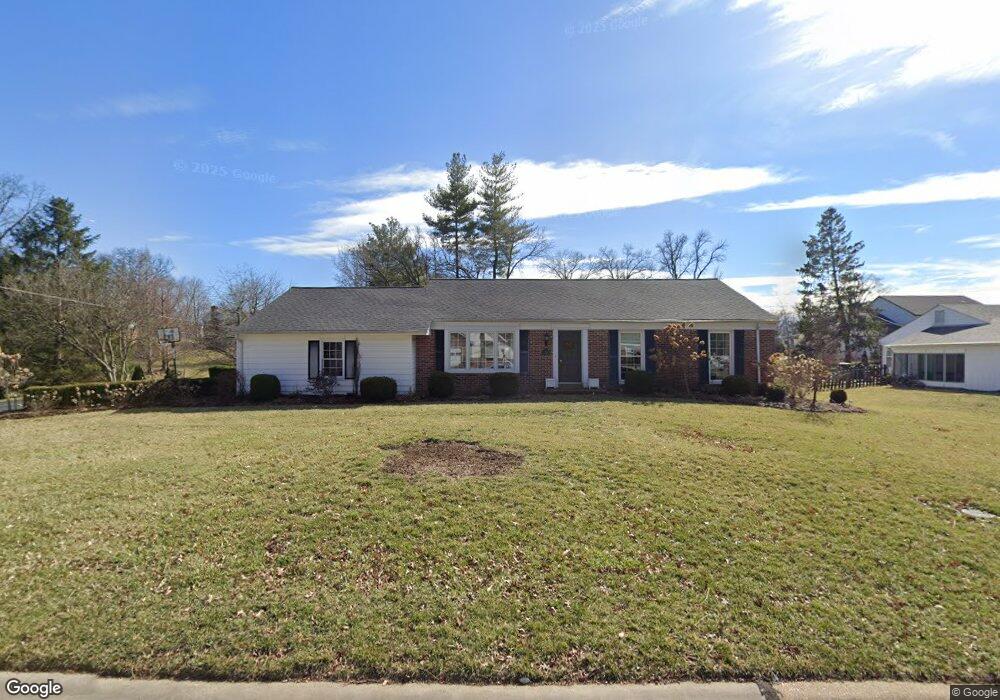
722 Oak Valley Dr Saint Louis, MO 63131
Estimated Value: $730,000 - $766,000
3
Beds
3
Baths
1,530
Sq Ft
$483/Sq Ft
Est. Value
About This Home
This home is located at 722 Oak Valley Dr, Saint Louis, MO 63131 and is currently estimated at $739,629, approximately $483 per square foot. 722 Oak Valley Dr is a home located in St. Louis County with nearby schools including Westchester Elementary School, North Kirkwood Middle School, and Kirkwood Senior High School.
Ownership History
Date
Name
Owned For
Owner Type
Purchase Details
Closed on
Jan 17, 2013
Sold by
The Revocable Living Trust Agreement Of
Bought by
Berchelmann Susan L and Denney Mark A
Current Estimated Value
Home Financials for this Owner
Home Financials are based on the most recent Mortgage that was taken out on this home.
Original Mortgage
$324,707
Outstanding Balance
$225,347
Interest Rate
3.33%
Mortgage Type
New Conventional
Estimated Equity
$514,282
Purchase Details
Closed on
Jan 8, 2004
Sold by
Denos Ellis and Denos Angeline
Bought by
Denos Ellis George and The Revocable Living Trust Agreement Of
Purchase Details
Closed on
Apr 2, 2002
Sold by
Doxsee Leigh A and Doxsee Joan T
Bought by
Denos Ellis and Denos Angeline
Home Financials for this Owner
Home Financials are based on the most recent Mortgage that was taken out on this home.
Original Mortgage
$300,000
Interest Rate
5.81%
Mortgage Type
Purchase Money Mortgage
Create a Home Valuation Report for This Property
The Home Valuation Report is an in-depth analysis detailing your home's value as well as a comparison with similar homes in the area
Home Values in the Area
Average Home Value in this Area
Purchase History
We collect this data history from publicly available records. To have your information removed, we recommend requesting removal directly through your county’s website.
| Date | Buyer | Sale Price | Title Company |
|---|---|---|---|
| Berchelmann Susan L | $355,000 | Us Title Main | |
| Denos Ellis George | -- | -- | |
| Denos Ellis | $340,000 | -- |
Source: Public Records
Mortgage History
We collect this data history from publicly available records. To have your information removed, we recommend requesting removal directly through your county’s website.
| Date | Status | Borrower | Loan Amount |
|---|---|---|---|
| Open | Berchelmann Susan L | $324,707 | |
| Previous Owner | Denos Ellis | $300,000 |
Source: Public Records
Tax History
| Year | Tax Paid | Tax Assessment Tax Assessment Total Assessment is a certain percentage of the fair market value that is determined by local assessors to be the total taxable value of land and additions on the property. | Land | Improvement |
|---|---|---|---|---|
| 2025 | $6,266 | $128,690 | $64,680 | $64,010 |
| 2024 | $6,266 | $108,330 | $52,550 | $55,780 |
| 2023 | $6,169 | $108,330 | $52,550 | $55,780 |
| 2022 | $6,086 | $99,610 | $52,550 | $47,060 |
| 2021 | $4,433 | $73,220 | $52,550 | $20,670 |
| 2020 | $4,082 | $64,790 | $30,650 | $34,140 |
| 2019 | $4,087 | $64,790 | $30,650 | $34,140 |
| 2018 | $4,610 | $65,630 | $27,250 | $38,380 |
| 2017 | $4,623 | $65,630 | $27,250 | $38,380 |
| 2016 | $4,413 | $63,450 | $27,250 | $36,200 |
| 2015 | $4,418 | $63,450 | $27,250 | $36,200 |
| 2014 | $4,452 | $62,490 | $19,950 | $42,540 |
Source: Public Records
Map
Nearby Homes
- 1741 Pine Hill Dr
- 1535 Fawnvalley Dr
- 1449 Fairbrook Dr
- 1507 Windridge Dr
- 1456 Fawnvalley Ct
- 8 Briarbrook Trail
- 11915 Kendon Dr
- 715 Westchester Ct
- 1316 Fawnvalley Dr
- 11904 Mattox Ct
- 22 Countryside Ln
- 1223 Simmons Ave
- 2316 Divot Dr
- 11344 Manchester Rd
- 1133 N Geyer Rd
- 11101 Hermitage Hill Rd
- 17 Bridle Ridge Ln
- 2030 N Ballas Rd
- 9 Bridle Ridge Ln
- TBB Ballas Ridge Hawthorne II
- 730 Oak Valley Dr
- 11701 Fawnridge Dr
- 700 Oak Valley Dr
- 738 Oak Valley Dr
- 11703 Fawnridge Dr
- 1564 Breezeridge Dr
- 11703UC Fawnridge Dr
- 11703 Fawnridge Dr
- 737 Oak Valley Dr
- 1706 Pine Hill Dr
- 727 Twin Fawns Dr
- 11711 Fawnridge Dr
- 746 Oak Valley Dr
- 1556 Breezeridge Dr
- 1705 Pine Hill Dr
- 1637 Woodgate Dr
- 1701 Butternut Dr
- 1714 Pine Hill Dr
- 1700 Folkstone Dr
- 11719 Fawnridge Dr
Your Personal Tour Guide
Ask me questions while you tour the home.