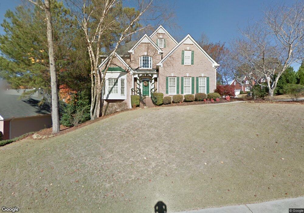
729 Shadow Trace Path Lilburn, GA 30047
Estimated Value: $500,982 - $543,000
4
Beds
3
Baths
2,935
Sq Ft
$180/Sq Ft
Est. Value
About This Home
This home is located at 729 Shadow Trace Path, Lilburn, GA 30047 and is currently estimated at $528,746, approximately $180 per square foot. 729 Shadow Trace Path is a home with nearby schools including Camp Creek Elementary School, Trickum Middle School, and Parkview High School.
Ownership History
Date
Name
Owned For
Owner Type
Purchase Details
Closed on
May 7, 1999
Sold by
Nash Properties Inc
Bought by
Craig John L and Craig Sharon L
Current Estimated Value
Home Financials for this Owner
Home Financials are based on the most recent Mortgage that was taken out on this home.
Original Mortgage
$141,150
Outstanding Balance
$34,833
Interest Rate
6.98%
Mortgage Type
New Conventional
Estimated Equity
$493,913
Create a Home Valuation Report for This Property
The Home Valuation Report is an in-depth analysis detailing your home's value as well as a comparison with similar homes in the area
Home Values in the Area
Average Home Value in this Area
Purchase History
| Date | Buyer | Sale Price | Title Company |
|---|---|---|---|
| Craig John L | $208,400 | -- |
Source: Public Records
Mortgage History
| Date | Status | Borrower | Loan Amount |
|---|---|---|---|
| Open | Craig John L | $141,150 |
Source: Public Records
Tax History
| Year | Tax Paid | Tax Assessment Tax Assessment Total Assessment is a certain percentage of the fair market value that is determined by local assessors to be the total taxable value of land and additions on the property. | Land | Improvement |
|---|---|---|---|---|
| 2025 | $5,654 | $210,160 | $36,000 | $174,160 |
| 2024 | $5,820 | $211,040 | $36,000 | $175,040 |
| 2023 | $5,820 | $208,440 | $42,800 | $165,640 |
| 2022 | $5,165 | $180,880 | $31,600 | $149,280 |
| 2021 | $4,406 | $140,720 | $27,600 | $113,120 |
| 2020 | $4,256 | $132,280 | $23,600 | $108,680 |
| 2019 | $3,670 | $110,320 | $19,200 | $91,120 |
| 2018 | $3,675 | $110,320 | $19,200 | $91,120 |
| 2016 | $3,740 | $112,240 | $19,200 | $93,040 |
| 2015 | $3,770 | $112,240 | $19,200 | $93,040 |
| 2014 | $3,788 | $112,240 | $19,200 | $93,040 |
Source: Public Records
Map
Nearby Homes
- 4307 Cedar Wood Dr SW
- 4424 Windsong Ct SW
- 577 Dorsey Cir SW
- 871 Cedar Trace SW
- 891 Cedar Trace SW
- 552 Ben Ct SW
- 710 Catamount Way SW
- 921 Cedar Trace SW
- 930 Cedar Bluff Trail SW
- 4304 Cedar Bluff Way SW
- 4587 Town Crier Rd SW
- 4706 Cedar Wood Dr SW Unit 1
- 445 Bruce Way SW
- 733 Ridgeview Dr SW Unit 3
- 551 Village Green Ct SW
- 4673 Arrowhead Trail SW
- 505 Saint Marks Dr SW
- 1296 Mandalay Ct SW
- 4816 Kittle Way
- 4777 Kittle Way
- 4333 Kenion Forest Dr
- 4330 Kenion Forest Dr
- 719 Shadow Trace Path
- 739 Shadow Trace Path
- 4313 Kenion Forest Dr Unit 1
- 704 Shadow Trace Path Unit 1
- 700 Trillium Ln
- 720 Trillium Ln
- 4336 Moonlight Walk
- 749 Shadow Trace Path
- 714 Shadow Trace Path
- 4310 Kenion Forest Dr
- 4303 Kenion Forest Dr Unit 1
- 4303 Kenion Forest Dr
- 4346 Moonlight Walk Unit 4
- 4326 Moonlight Walk Unit 4
- 687 Killian Hill Rd SW
- 730 Trillium Ln
- 4316 Moonlight Walk Unit 4
- 0 Killian Hill Rd SW
Your Personal Tour Guide
Ask me questions while you tour the home.