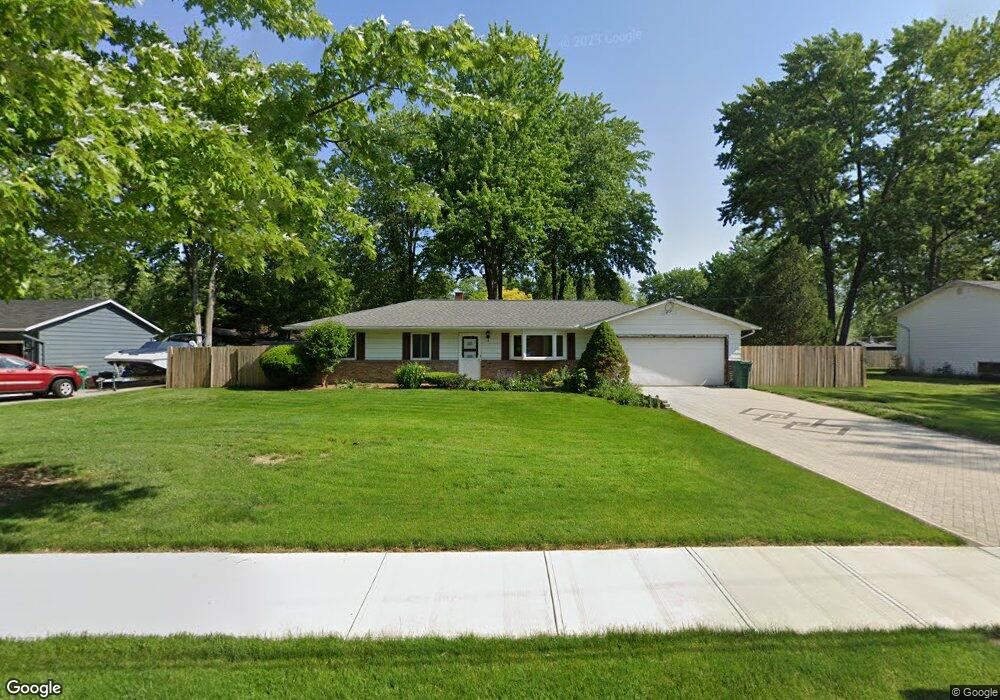
7295 Brownell Dr Mentor, OH 44060
Estimated Value: $244,000 - $284,000
3
Beds
2
Baths
1,396
Sq Ft
$191/Sq Ft
Est. Value
About This Home
This home is located at 7295 Brownell Dr, Mentor, OH 44060 and is currently estimated at $266,822, approximately $191 per square foot. 7295 Brownell Dr is a home located in Lake County with nearby schools including Memorial Middle School, Mentor High School, and Andrews Osborne Academy.
Ownership History
Date
Name
Owned For
Owner Type
Purchase Details
Closed on
Jun 27, 2000
Sold by
Lardin Patricia J
Bought by
Falatic Andrew J
Current Estimated Value
Home Financials for this Owner
Home Financials are based on the most recent Mortgage that was taken out on this home.
Original Mortgage
$109,000
Outstanding Balance
$37,924
Interest Rate
8.66%
Estimated Equity
$228,898
Purchase Details
Closed on
Jan 1, 1990
Bought by
Lardin Jack N
Create a Home Valuation Report for This Property
The Home Valuation Report is an in-depth analysis detailing your home's value as well as a comparison with similar homes in the area
Home Values in the Area
Average Home Value in this Area
Purchase History
| Date | Buyer | Sale Price | Title Company |
|---|---|---|---|
| Falatic Andrew J | $148,000 | Enterprise Title Agency Inc | |
| Lardin Jack N | -- | -- |
Source: Public Records
Mortgage History
| Date | Status | Borrower | Loan Amount |
|---|---|---|---|
| Open | Falatic Andrew J | $109,000 |
Source: Public Records
Tax History
| Year | Tax Paid | Tax Assessment Tax Assessment Total Assessment is a certain percentage of the fair market value that is determined by local assessors to be the total taxable value of land and additions on the property. | Land | Improvement |
|---|---|---|---|---|
| 2025 | -- | $74,180 | $18,260 | $55,920 |
| 2024 | -- | $74,180 | $18,260 | $55,920 |
| 2023 | -- | $64,930 | $14,900 | $50,030 |
| 2022 | $2,991 | $64,930 | $14,900 | $50,030 |
| 2021 | $3,000 | $64,930 | $14,900 | $50,030 |
| 2020 | $2,899 | $55,030 | $12,630 | $42,400 |
| 2019 | $2,903 | $55,030 | $12,630 | $42,400 |
| 2018 | $2,894 | $46,630 | $18,840 | $27,790 |
| 2017 | $2,577 | $46,630 | $18,840 | $27,790 |
| 2016 | $2,562 | $46,630 | $18,840 | $27,790 |
| 2015 | $2,336 | $46,630 | $18,840 | $27,790 |
| 2014 | $2,370 | $46,630 | $18,840 | $27,790 |
| 2013 | $2,373 | $46,630 | $18,840 | $27,790 |
Source: Public Records
Map
Nearby Homes
- 3 Adkins Rd
- 7585 Bar Harbour Ln
- 7507 Essex Dr
- 7440 Clover Ave
- 7101 Reynolds Rd
- 7109 W Jefferson Dr
- 7654 Ohio St
- 38612 Bell Rd
- 7530 Mentor Ave
- 2401 Bunker Ln Unit A
- 0 Lost Nation Rd
- 3000 Steve Guard Ct
- 2640 Lost Nation Rd
- 38396 Poplar Dr
- 2977 Gale Rd
- 38136 Parkway Blvd
- 3144 Lost Nation Rd
- 7772 Barnaby Ln
- 541 Howells Ct
- 7670 Garfield Rd
- 7285 Brownell Dr
- 7305 Brownell Dr
- 7298 Erie Dr
- 7290 Erie Dr
- 7273 Brownell Dr
- 7315 Brownell Dr
- 7300 Brownell Dr
- 7290 Brownell Dr
- 7308 Erie Dr
- 7280 Brownell Dr
- 7274 Erie Dr
- 7263 Brownell Dr
- 7325 Brownell Dr
- 7310 Brownell Dr
- 7270 Brownell Dr
- 7324 Erie Dr
- 7289 Erie Dr
- 7287 Erie Dr
- 7260 Erie Dr
- 7324 Brownell Dr
Your Personal Tour Guide
Ask me questions while you tour the home.