Estimated Value: $97,000 - $113,000
Studio
1
Bath
580
Sq Ft
$185/Sq Ft
Est. Value
About This Home
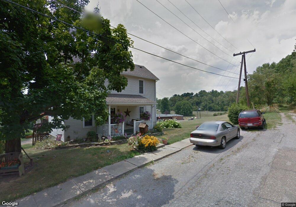
This home is located at 730 Locust St, Cadiz, OH 43907 and is currently estimated at $107,374, approximately $185 per square foot. 730 Locust St is a home located in Harrison County with nearby schools including Harrison Central Elementary School and Harrison Central Junior/Senior High School.
Ownership History
Date
Name
Owned For
Owner Type
Purchase Details
Closed on
Dec 20, 2025
Sold by
Byers Carl J and Byers Sarah L
Bought by
Ott Thomas W and Ott Ariel R
Current Estimated Value
Home Financials for this Owner
Home Financials are based on the most recent Mortgage that was taken out on this home.
Original Mortgage
$112,000
Outstanding Balance
$111,892
Interest Rate
6.19%
Mortgage Type
New Conventional
Estimated Equity
-$4,518
Purchase Details
Closed on
Nov 20, 2019
Sold by
Mccann Richard L and Mccann Patricia A
Bought by
Byers Carl J and Byers Sarah L
Home Financials for this Owner
Home Financials are based on the most recent Mortgage that was taken out on this home.
Original Mortgage
$30,000
Interest Rate
3.5%
Mortgage Type
New Conventional
Purchase Details
Closed on
Jan 31, 2002
Purchase Details
Closed on
Nov 20, 1990
Create a Home Valuation Report for This Property
The Home Valuation Report is an in-depth analysis detailing your home's value as well as a comparison with similar homes in the area
Home Values in the Area
Average Home Value in this Area
Purchase History
We collect this data history from publicly available records. To have your information removed, we recommend requesting removal directly through your county’s website.
| Date | Buyer | Sale Price | Title Company |
|---|---|---|---|
| Ott Thomas W | $112,000 | Gba Legal Services | |
| Byers Carl J | $38,000 | None Available | |
| -- | -- | -- | |
| -- | -- | -- |
Source: Public Records
Mortgage History
We collect this data history from publicly available records. To have your information removed, we recommend requesting removal directly through your county’s website.
| Date | Status | Borrower | Loan Amount |
|---|---|---|---|
| Open | Ott Thomas W | $112,000 | |
| Previous Owner | Byers Carl J | $30,000 |
Source: Public Records
Tax History
| Year | Tax Paid | Tax Assessment Tax Assessment Total Assessment is a certain percentage of the fair market value that is determined by local assessors to be the total taxable value of land and additions on the property. | Land | Improvement |
|---|---|---|---|---|
| 2025 | $840 | $21,120 | $5,250 | $15,870 |
| 2024 | $840 | $21,120 | $5,250 | $15,870 |
| 2023 | $839 | $21,120 | $5,250 | $15,870 |
| 2022 | $721 | $16,970 | $3,840 | $13,130 |
| 2021 | $697 | $16,970 | $3,840 | $13,130 |
| 2020 | $695 | $16,970 | $3,840 | $13,130 |
| 2019 | $596 | $14,390 | $3,260 | $11,130 |
| 2018 | $596 | $14,390 | $3,260 | $11,130 |
| 2017 | $570 | $14,390 | $3,260 | $11,130 |
| 2016 | $537 | $11,960 | $2,310 | $9,650 |
| 2015 | $536 | $11,960 | $2,310 | $9,650 |
| 2014 | $436 | $11,460 | $2,100 | $9,360 |
| 2013 | $436 | $11,460 | $2,100 | $9,360 |
Source: Public Records
Map
Nearby Homes
- 608 Mccready Ave
- 610 Peppard Ave
- 593 Dewey Ave
- 43125 Dennison Ave
- 331 Saint Clair Ave
- 166 S Ohio St
- 134 Martin Ave
- 158 Martin Ave
- 42250 Cadiz Dennison Rd
- 44208 Meadowlark Ln
- 742 E Market St
- 0 E Market St
- 0 Monzula Dr
- 47480 Unionvale Rd
- 0 Brewer Rd
- 78791 Kanoski Rd
- 77900 Slater Rd
- 38340 Lees Run Rd
- 85200 Merryman Rd
- 47813 Old Hopedale Rd
- 646 Mccready Ave
- 652 Mccready Ave
- 650 Mccready Ave
- 654 Mccready Ave
- 642 Mccready Ave
- 656 Mccready Ave
- 658 Mccready Ave
- 632 Mccready Ave
- 662 Mccready Ave
- 628 Mccready Ave
- 731 Locust St
- 649 Mccready Ave
- 664 Mccready Ave
- 624 Mccready Ave
- 651 Mccready Ave
- 620 Mccready Ave
- 655 Mccready Ave
- 661 Mccready Ave
- 665 Mccready Ave
- 709 Peppard Ave
Your Personal Tour Guide
Ask me questions while you tour the home.