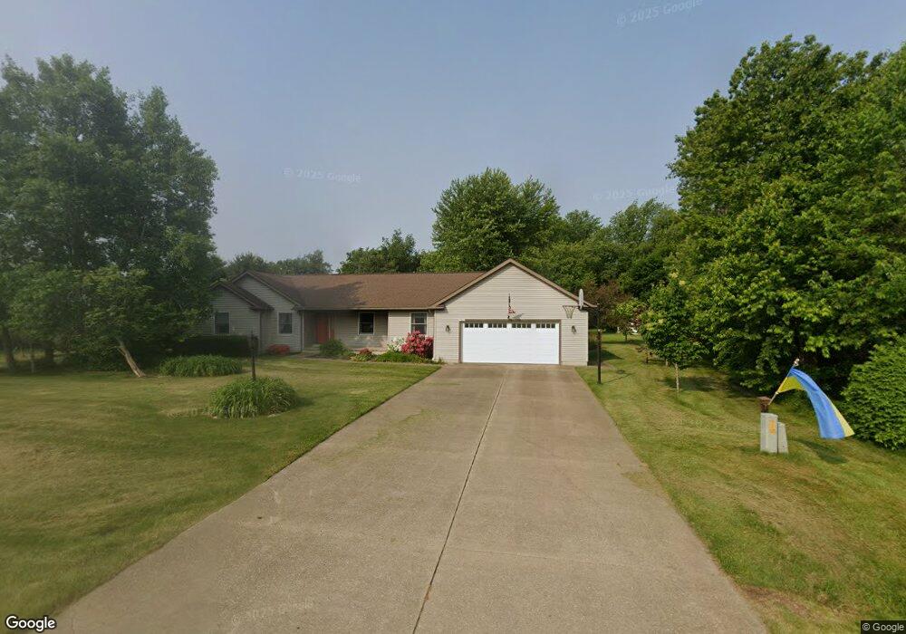
7319 Fieldstone Ave Conneaut, OH 44030
Kingsville NeighborhoodEstimated Value: $286,000 - $388,000
3
Beds
2
Baths
2,231
Sq Ft
$150/Sq Ft
Est. Value
About This Home
This home is located at 7319 Fieldstone Ave, Conneaut, OH 44030 and is currently estimated at $335,455, approximately $150 per square foot. 7319 Fieldstone Ave is a home located in Ashtabula County with nearby schools including Kingsville Elementary School, Ridgeview Elementary School, and Wallace H. Braden Junior High School.
Ownership History
Date
Name
Owned For
Owner Type
Purchase Details
Closed on
May 22, 1996
Sold by
Wing Peter J
Bought by
Fine Ronald L and Fine Tomalyn J
Current Estimated Value
Home Financials for this Owner
Home Financials are based on the most recent Mortgage that was taken out on this home.
Original Mortgage
$130,500
Interest Rate
8.1%
Mortgage Type
New Conventional
Create a Home Valuation Report for This Property
The Home Valuation Report is an in-depth analysis detailing your home's value as well as a comparison with similar homes in the area
Home Values in the Area
Average Home Value in this Area
Purchase History
| Date | Buyer | Sale Price | Title Company |
|---|---|---|---|
| Fine Ronald L | $19,500 | -- |
Source: Public Records
Mortgage History
| Date | Status | Borrower | Loan Amount |
|---|---|---|---|
| Previous Owner | Fine Ronald L | $130,500 |
Source: Public Records
Tax History
| Year | Tax Paid | Tax Assessment Tax Assessment Total Assessment is a certain percentage of the fair market value that is determined by local assessors to be the total taxable value of land and additions on the property. | Land | Improvement |
|---|---|---|---|---|
| 2024 | $6,626 | $93,170 | $14,210 | $78,960 |
| 2023 | $2,896 | $93,170 | $14,210 | $78,960 |
| 2022 | $2,332 | $69,410 | $10,920 | $58,490 |
| 2021 | $2,333 | $69,410 | $10,920 | $58,490 |
| 2020 | $2,360 | $69,410 | $10,920 | $58,490 |
| 2019 | $2,499 | $70,140 | $12,670 | $57,470 |
| 2018 | $2,406 | $70,140 | $12,670 | $57,470 |
| 2017 | $1,203 | $70,140 | $12,670 | $57,470 |
| 2016 | $2,045 | $60,480 | $10,920 | $49,560 |
| 2015 | $2,043 | $60,480 | $10,920 | $49,560 |
| 2014 | $1,976 | $60,480 | $10,920 | $49,560 |
| 2013 | $1,905 | $59,080 | $8,750 | $50,330 |
Source: Public Records
Map
Nearby Homes
- 7296 Poore Rd
- 7032 Reed Rd
- 6989 Reed Rd
- 7011 Richwood Dr
- 7435 Glenwood Rd
- 7630 Darling Ave
- 3343 Lake Rd
- 3339 Lake Rd
- 4017 Lake Rd Unit 17
- 3241 S Forest Dr
- 2940 Corries Way
- 2928 Placid Pointe Rd
- 0 Creek Rd Unit 5172426
- 0 Village Green Unit 5169512
- 436 Keefus Rd
- 1381 Robb Rd
- 2905 Shirley St
- 3172 Creek Rd
- 6424 Walrath Cir
- 7223 Kenmore Ave
- 3874 Fox Chase Cir
- 7335 Fieldstone Ave
- 7318 Fieldstone Ave
- 3857 Fox Chase Cir
- 4780 Sandstone Ct
- 7304 Fieldstone Ave
- 3843 Fox Chase Cir
- 7288 Fieldstone Ave
- 7270 Harmony Glen Dr
- 7284 Harmony Glen Dr
- 7330 Harmony Glen
- 7330 Harmony Glen Dr
- 7251 Fieldstone Ave
- 4781 Sandstone Ct
- 7256 Harmony Glen Dr
- 4804 Sandstone Ct
- 7363 Fieldstone Ave
- 7272 Fieldstone Ave
- 3781 Pinestone Ct
- 7236 Fieldstone Ave
Your Personal Tour Guide
Ask me questions while you tour the home.