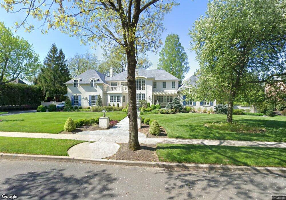
732 Mill St Moorestown, NJ 08057
Estimated Value: $1,501,303 - $1,760,000
Studio
--
Bath
4,840
Sq Ft
$345/Sq Ft
Est. Value
About This Home
This home is located at 732 Mill St, Moorestown, NJ 08057 and is currently estimated at $1,671,768, approximately $345 per square foot. 732 Mill St is a home located in Burlington County with nearby schools including George C. Baker Elementary School, Moorestown Upper Elementary School, and William Allen Middle School.
Ownership History
Date
Name
Owned For
Owner Type
Purchase Details
Closed on
Jun 22, 2023
Sold by
Vasso Stephen G and Vasso Edna L
Bought by
Vasso Stephen G
Current Estimated Value
Purchase Details
Closed on
Dec 17, 2019
Sold by
Vasso Stephen G and The Stephen G Vasso Revocable
Bought by
Vasso Stephen G and Vasso Edna L
Purchase Details
Closed on
Jan 19, 2011
Sold by
Vasso Stephen G
Bought by
Vasso Stephen G
Purchase Details
Closed on
May 11, 1999
Sold by
Vasso Stephen G and Vasso Edna L
Bought by
Vasso Edna L
Purchase Details
Closed on
Jul 7, 1993
Sold by
Talarico Joseph
Bought by
Vasso Stephen G and Vasso Edna
Home Financials for this Owner
Home Financials are based on the most recent Mortgage that was taken out on this home.
Original Mortgage
$220,000
Interest Rate
7.08%
Create a Home Valuation Report for This Property
The Home Valuation Report is an in-depth analysis detailing your home's value as well as a comparison with similar homes in the area
Home Values in the Area
Average Home Value in this Area
Purchase History
We collect this data history from publicly available records. To have your information removed, we recommend requesting removal directly through your county’s website.
| Date | Buyer | Sale Price | Title Company |
|---|---|---|---|
| Vasso Stephen G | -- | None Listed On Document | |
| Vasso Stephen G | -- | None Listed On Document | |
| Vasso Stephen G | -- | None Available | |
| Vasso Stephen G | -- | None Available | |
| Vasso Stephen G | -- | None Available | |
| Vasso Edna L | -- | -- | |
| Vasso Stephen G | $322,500 | -- |
Source: Public Records
Mortgage History
We collect this data history from publicly available records. To have your information removed, we recommend requesting removal directly through your county’s website.
| Date | Status | Borrower | Loan Amount |
|---|---|---|---|
| Previous Owner | Vasso Stephen G | $220,000 |
Source: Public Records
Tax History
| Year | Tax Paid | Tax Assessment Tax Assessment Total Assessment is a certain percentage of the fair market value that is determined by local assessors to be the total taxable value of land and additions on the property. | Land | Improvement |
|---|---|---|---|---|
| 2025 | $24,483 | $863,000 | $175,000 | $688,000 |
| 2024 | $23,741 | $863,000 | $175,000 | $688,000 |
| 2023 | $23,741 | $863,000 | $175,000 | $688,000 |
| 2022 | $23,499 | $863,000 | $175,000 | $688,000 |
| 2021 | $23,189 | $863,000 | $175,000 | $688,000 |
| 2020 | $23,042 | $863,000 | $175,000 | $688,000 |
| 2019 | $22,636 | $863,000 | $175,000 | $688,000 |
| 2018 | $22,024 | $863,000 | $175,000 | $688,000 |
| 2017 | $22,214 | $863,000 | $175,000 | $688,000 |
| 2016 | $22,136 | $863,000 | $175,000 | $688,000 |
| 2015 | $21,868 | $863,000 | $175,000 | $688,000 |
| 2014 | $20,764 | $863,000 | $175,000 | $688,000 |
Source: Public Records
Map
Nearby Homes
- 720 Maple Ct
- 11 W Spruce Ave
- 705 Iron Post Rd
- 543 Bethel Ave
- 421 Irving Ave
- 500 Chester Ave
- 117 W Central Ave
- 35 Oriole Way
- 904 Heritage Rd
- 863 Golf View Rd
- 201 E Oak Ave
- 1416 Georgian Dr
- 210 E Oak Ave
- 66 E 3rd St
- 80 E 3rd St
- 205 E Central Ave
- 140 E Central Ave
- 15 E 2nd St
- 322 Chestnut St
- 129 Plum St Unit C4
Your Personal Tour Guide
Ask me questions while you tour the home.