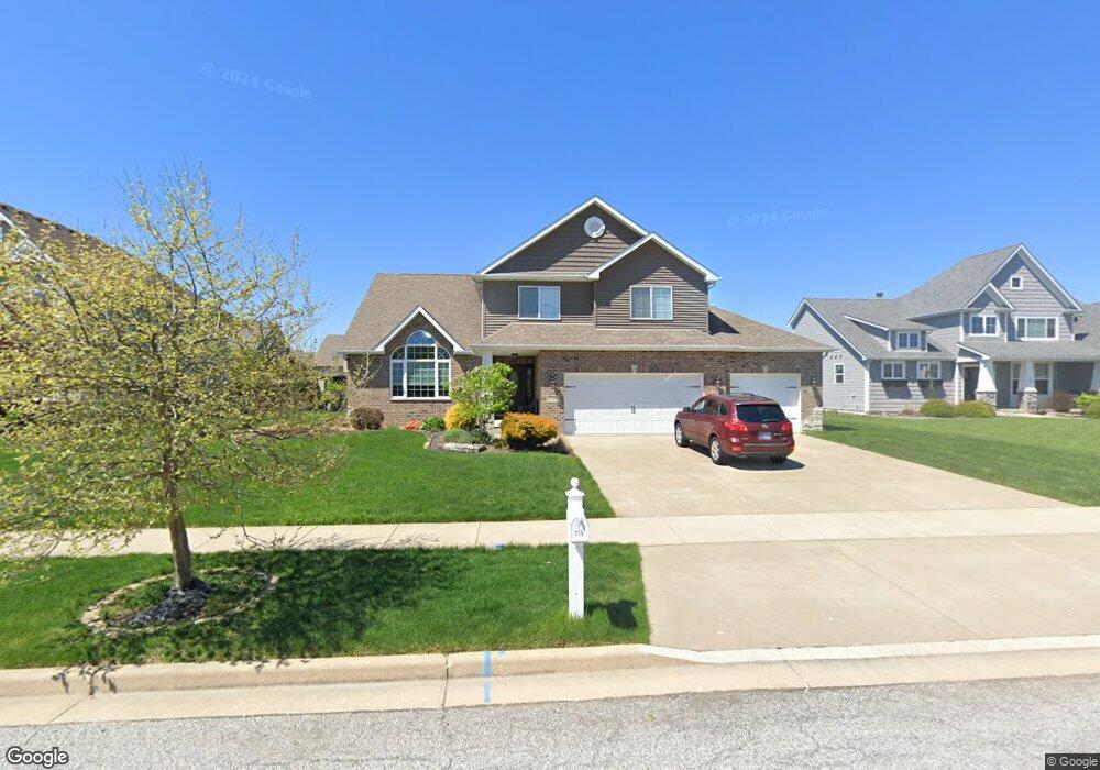
735 Huey Dr Crown Point, IN 46307
Estimated Value: $480,468 - $585,000
4
Beds
3
Baths
2,477
Sq Ft
$219/Sq Ft
Est. Value
About This Home
This home is located at 735 Huey Dr, Crown Point, IN 46307 and is currently estimated at $542,617, approximately $219 per square foot. 735 Huey Dr is a home located in Lake County with nearby schools including Lake Street Elementary School, Robert Taft Middle School, and Crown Point High School.
Ownership History
Date
Name
Owned For
Owner Type
Purchase Details
Closed on
Aug 21, 2013
Sold by
The Chicago Trust Company Na
Bought by
Cortopasse Scott C and Cortopasse Lisa
Current Estimated Value
Home Financials for this Owner
Home Financials are based on the most recent Mortgage that was taken out on this home.
Original Mortgage
$236,175
Outstanding Balance
$173,942
Interest Rate
4.38%
Mortgage Type
New Conventional
Estimated Equity
$368,675
Create a Home Valuation Report for This Property
The Home Valuation Report is an in-depth analysis detailing your home's value as well as a comparison with similar homes in the area
Home Values in the Area
Average Home Value in this Area
Purchase History
| Date | Buyer | Sale Price | Title Company |
|---|---|---|---|
| Cortopasse Scott C | -- | Meridian Title |
Source: Public Records
Mortgage History
| Date | Status | Borrower | Loan Amount |
|---|---|---|---|
| Open | Cortopasse Scott C | $236,175 |
Source: Public Records
Tax History
| Year | Tax Paid | Tax Assessment Tax Assessment Total Assessment is a certain percentage of the fair market value that is determined by local assessors to be the total taxable value of land and additions on the property. | Land | Improvement |
|---|---|---|---|---|
| 2025 | $4,732 | $477,800 | $75,600 | $402,200 |
| 2024 | $11,609 | $459,500 | $75,600 | $383,900 |
| 2023 | $4,487 | $422,400 | $75,600 | $346,800 |
| 2022 | $4,487 | $400,800 | $75,600 | $325,200 |
| 2021 | $4,393 | $392,500 | $60,100 | $332,400 |
| 2020 | $4,302 | $384,500 | $60,100 | $324,400 |
| 2019 | $4,307 | $381,000 | $60,100 | $320,900 |
| 2018 | $5,433 | $374,900 | $60,100 | $314,800 |
| 2017 | $5,180 | $355,800 | $60,100 | $295,700 |
| 2016 | $4,880 | $332,900 | $55,500 | $277,400 |
| 2014 | $4,320 | $317,100 | $55,500 | $261,600 |
| 2013 | $5 | $100 | $100 | $0 |
Source: Public Records
Map
Nearby Homes
- 745 Huey Dr
- 778 Ronny Ct
- 770 Quinlan Ct
- 1021 Foy Ct
- 1030 Foy Ct
- 1144 Mary Ellen Dr
- 1089 George Ade Ct
- 914 Lillian Russell Ct
- 804 Shannon Dr
- 964 Ryan Ct
- 12109 White Oak Dr
- 669 Davis Cir
- 3709 W 121st Ave
- 815 Hayfield Dr
- 3516 W 123rd Place
- 629 W South St
- 11217 Burr Parcel 2 St
- 207 Harrington Ave
- 5828 W 122nd Ave
- 1002 Gordon Ct
Your Personal Tour Guide
Ask me questions while you tour the home.