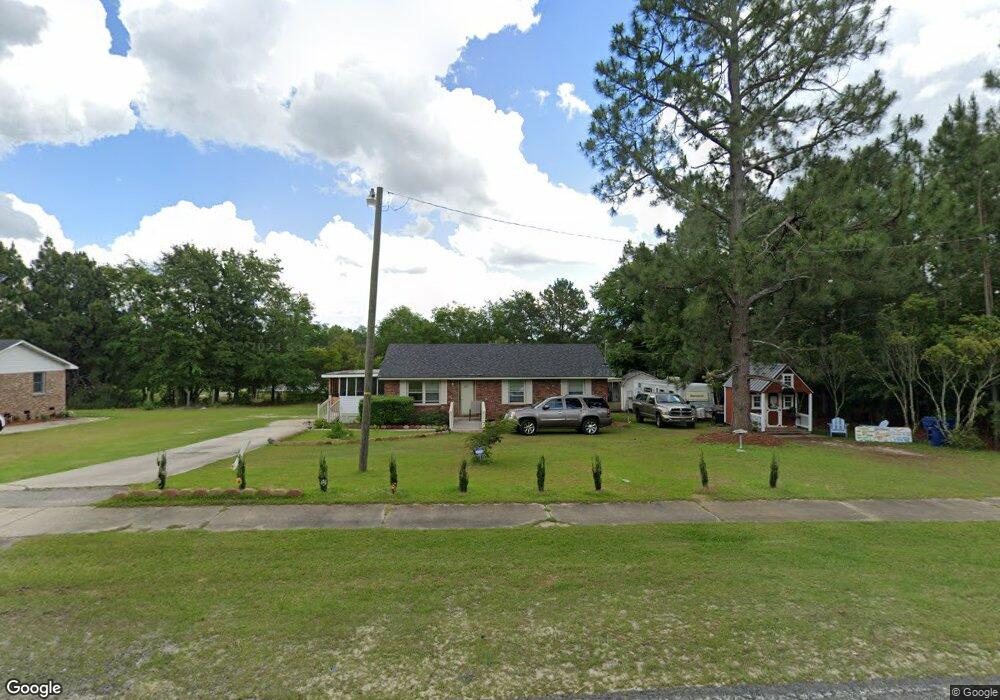
737 S 9th St Mc Bee, SC 29101
Estimated Value: $79,000 - $162,000
Studio
--
Bath
1,050
Sq Ft
$117/Sq Ft
Est. Value
About This Home
This home is located at 737 S 9th St, Mc Bee, SC 29101 and is currently estimated at $123,050, approximately $117 per square foot. 737 S 9th St is a home with nearby schools including McBee Elementary School, McBee High School, and New Heights Middle School.
Ownership History
Date
Name
Owned For
Owner Type
Purchase Details
Closed on
Feb 26, 2018
Sold by
Muldrow Carol
Bought by
Ponds John W
Current Estimated Value
Purchase Details
Closed on
Dec 20, 2017
Sold by
Brister Patricia A
Bought by
Ponds John W
Purchase Details
Closed on
Dec 18, 2017
Sold by
Dewitt James E
Bought by
Ponds John W
Purchase Details
Closed on
Nov 22, 2017
Sold by
Brister Patricia A
Bought by
Ponds John Wesley
Purchase Details
Closed on
Jan 15, 2017
Sold by
Dewitt J C
Bought by
Ponds John Wesley
Create a Home Valuation Report for This Property
The Home Valuation Report is an in-depth analysis detailing your home's value as well as a comparison with similar homes in the area
Purchase History
| Date | Buyer | Sale Price | Title Company |
|---|---|---|---|
| Ponds John W | -- | -- | |
| Ponds John W | -- | -- | |
| Ponds John W | -- | -- | |
| Ponds John Wesley | $3,000 | None Available | |
| Ponds John Wesley | $3,000 | None Available | |
| Ponds John Wesley | -- | None Available |
Source: Public Records
Tax History
| Year | Tax Paid | Tax Assessment Tax Assessment Total Assessment is a certain percentage of the fair market value that is determined by local assessors to be the total taxable value of land and additions on the property. | Land | Improvement |
|---|---|---|---|---|
| 2025 | -- | $2,160 | $200 | $1,960 |
| 2024 | -- | $1,880 | $200 | $1,680 |
| 2023 | $0 | $1,880 | $200 | $1,680 |
| 2022 | $0 | $1,880 | $200 | $1,680 |
| 2021 | $677 | $1,880 | $200 | $1,680 |
| 2020 | $677 | $1,880 | $200 | $1,680 |
| 2019 | $763 | $1,840 | $160 | $1,680 |
| 2018 | $748 | $1,840 | $160 | $1,680 |
| 2015 | -- | $2,760 | $240 | $2,520 |
| 2014 | -- | $1,840 | $160 | $1,680 |
| 2010 | -- | $1,880 | $160 | $1,720 |
Source: Public Records
Map
Nearby Homes
- Lot 9-14 Maple Ave
- 0 Us Highway 1 South Seventh St Unit 20223111
- 0 Route 1 Unit Lot 92
- 151 E Pine Ave
- Lot 30 Norwood Farms
- Lot 25 Norwood Farms
- Lot 32 Norwood Farms
- Lot 34 Norwood Farms
- Lot 28 Norwood Farm
- Lot 38 Norwood Farms
- Lot 36 Norwood Farms
- Lot 26 Norwood Farms
- 25560 Hwy 151
- 2642 Mckenzie Rd
- Overflow Rd
- 2117 & 2109 Togetherness Way
- 000 Overflow Rd
- 21 Rolling Hills Rd
- 3048 Timrod Rd
- 1652 Ashland Rd
- 719 S Ninth St
- 697 S 9th St
- 781 S 9th St
- 675 S 9th St
- 195 E Union Church Rd
- 648 S 9th St
- 579 S 10th St
- 444 S 10th St
- 4795 Union Church Rd
- 200 E Union Church Rd
- 240 E Union Church Rd
- 701 S 10th St
- 701 S 10th St Unit 1
- 701 S 10th St
- 260 E Union Church Rd
- 93 S Side Dr
- 146 E Union Church Rd
- 124 E Union Church Rd
- 784 11th St
- 720 11th St
Your Personal Tour Guide
Ask me questions while you tour the home.