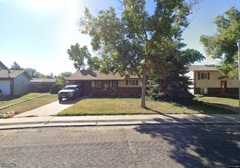
746 Mobile St Aurora, CO 80011
Laredo Highline NeighborhoodEstimated Value: $389,268 - $424,000
3
Beds
2
Baths
925
Sq Ft
$441/Sq Ft
Est. Value
About This Home
This home is located at 746 Mobile St, Aurora, CO 80011 and is currently estimated at $407,817, approximately $440 per square foot. 746 Mobile St is a home located in Arapahoe County with nearby schools including Laredo Elementary School, East Middle School, and Hinkley High School.
Ownership History
Date
Name
Owned For
Owner Type
Purchase Details
Closed on
Apr 2, 2004
Sold by
Gibbons R Dennis and Gibbons Robert Dennis
Bought by
Gibbons R Dennis
Current Estimated Value
Home Financials for this Owner
Home Financials are based on the most recent Mortgage that was taken out on this home.
Original Mortgage
$55,145
Outstanding Balance
$23,717
Interest Rate
4.75%
Estimated Equity
$384,100
Purchase Details
Closed on
Dec 27, 1997
Sold by
Gibbons Cindy Lou
Bought by
Gibbons Robert Dennis
Purchase Details
Closed on
Sep 25, 1992
Sold by
Conversion Arapco
Bought by
Villers Cindy Jr Gibbons R and Villers Cindy
Purchase Details
Closed on
Mar 1, 1986
Sold by
Conversion Arapco
Bought by
Conversion Arapco
Purchase Details
Closed on
Jul 4, 1776
Bought by
Conversion Arapco
Create a Home Valuation Report for This Property
The Home Valuation Report is an in-depth analysis detailing your home's value as well as a comparison with similar homes in the area
Home Values in the Area
Average Home Value in this Area
Purchase History
We collect this data history from publicly available records. To have your information removed, we recommend requesting removal directly through your county’s website.
| Date | Buyer | Sale Price | Title Company |
|---|---|---|---|
| Gibbons R Dennis | -- | Fahtco | |
| Gibbons Robert Dennis | -- | -- | |
| Villers Cindy Jr Gibbons R | -- | -- | |
| Conversion Arapco | -- | -- | |
| Conversion Arapco | -- | -- |
Source: Public Records
Mortgage History
We collect this data history from publicly available records. To have your information removed, we recommend requesting removal directly through your county’s website.
| Date | Status | Borrower | Loan Amount |
|---|---|---|---|
| Open | Gibbons R Dennis | $55,145 |
Source: Public Records
Tax History
| Year | Tax Paid | Tax Assessment Tax Assessment Total Assessment is a certain percentage of the fair market value that is determined by local assessors to be the total taxable value of land and additions on the property. | Land | Improvement |
|---|---|---|---|---|
| 2025 | $1,925 | $24,625 | -- | -- |
| 2024 | $1,867 | $26,787 | -- | -- |
| 2023 | $1,867 | $26,787 | $0 | $0 |
| 2022 | $2,310 | $23,005 | $0 | $0 |
| 2021 | $2,384 | $23,005 | $0 | $0 |
| 2020 | $2,175 | $20,892 | $0 | $0 |
| 2019 | $2,164 | $20,892 | $0 | $0 |
| 2018 | $1,797 | $16,992 | $0 | $0 |
| 2017 | $1,563 | $16,992 | $0 | $0 |
| 2016 | $1,170 | $12,449 | $0 | $0 |
| 2015 | $1,129 | $12,449 | $0 | $0 |
| 2014 | $783 | $8,318 | $0 | $0 |
| 2013 | -- | $9,350 | $0 | $0 |
Source: Public Records
Map
Nearby Homes
- 757 Norfolk Way
- 752 Lewiston St
- 1036 Mobile St
- 1052 Lewiston St
- 15950 E 6th Ave
- 16010 E 11th Ave
- 1074 N Joplin St Unit 5
- 808 Idalia St
- 1053 N Joplin St Unit 1
- 1063 N Joplin St Unit 2
- 1166 Ouray St
- 1182 Nucla St
- 15497 E 7th Cir
- 16492 E 13th Place
- 1313 Laredo St
- 1064 Chambers Ct Unit 108
- 1447 Norfolk St
- 407 Ivory Cir
- 15703 E 13th Place Unit 1A
- 15771 E 13th Place Unit C34
Your Personal Tour Guide
Ask me questions while you tour the home.