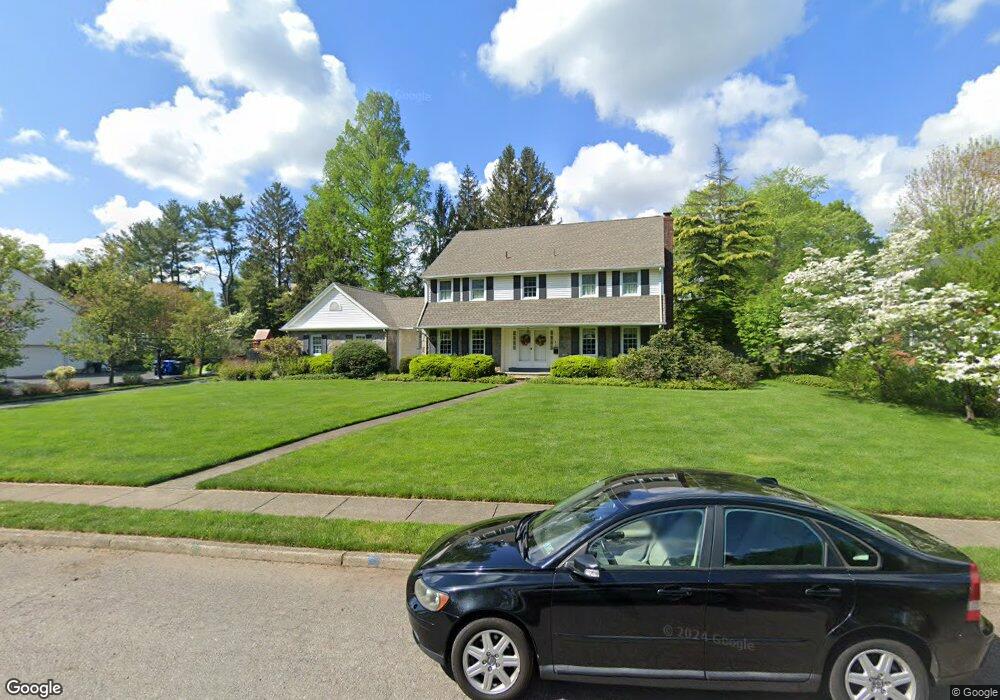
748 Paddock Path Moorestown, NJ 08057
Estimated Value: $1,029,898 - $1,196,000
Studio
--
Bath
2,835
Sq Ft
$390/Sq Ft
Est. Value
About This Home
This home is located at 748 Paddock Path, Moorestown, NJ 08057 and is currently estimated at $1,106,299, approximately $390 per square foot. 748 Paddock Path is a home located in Burlington County with nearby schools including George C. Baker Elementary School, Moorestown Upper Elementary School, and William Allen Middle School.
Ownership History
Date
Name
Owned For
Owner Type
Purchase Details
Closed on
Dec 16, 1996
Sold by
Cuthbertson Harry A and Cuthbertson Mary L
Bought by
Rando Richard F and Andreoli Rando Lisa M
Current Estimated Value
Home Financials for this Owner
Home Financials are based on the most recent Mortgage that was taken out on this home.
Original Mortgage
$190,000
Interest Rate
7.8%
Purchase Details
Closed on
Mar 3, 1995
Sold by
Cuthbertson Harry A and Cuthbertson Mary L
Bought by
Cuthbertson Harry A and Cuthbertson Mary L
Create a Home Valuation Report for This Property
The Home Valuation Report is an in-depth analysis detailing your home's value as well as a comparison with similar homes in the area
Home Values in the Area
Average Home Value in this Area
Purchase History
| Date | Buyer | Sale Price | Title Company |
|---|---|---|---|
| Rando Richard F | $365,000 | Lawrence Abstract Company | |
| Cuthbertson Harry A | -- | -- |
Source: Public Records
Mortgage History
| Date | Status | Borrower | Loan Amount |
|---|---|---|---|
| Previous Owner | Rando Richard F | $190,000 |
Source: Public Records
Tax History
| Year | Tax Paid | Tax Assessment Tax Assessment Total Assessment is a certain percentage of the fair market value that is determined by local assessors to be the total taxable value of land and additions on the property. | Land | Improvement |
|---|---|---|---|---|
| 2025 | $17,564 | $619,100 | $295,600 | $323,500 |
| 2024 | $17,031 | $619,100 | $295,600 | $323,500 |
| 2023 | $17,031 | $619,100 | $295,600 | $323,500 |
| 2022 | $16,858 | $619,100 | $295,600 | $323,500 |
| 2021 | $16,629 | $619,100 | $295,600 | $323,500 |
| 2020 | $16,530 | $619,100 | $295,600 | $323,500 |
| 2019 | $16,239 | $619,100 | $295,600 | $323,500 |
| 2018 | $15,799 | $619,100 | $295,600 | $323,500 |
| 2017 | $15,936 | $619,100 | $295,600 | $323,500 |
| 2016 | $15,880 | $619,100 | $295,600 | $323,500 |
| 2015 | $15,688 | $619,100 | $295,600 | $323,500 |
| 2014 | $14,896 | $619,100 | $295,600 | $323,500 |
Source: Public Records
Map
Nearby Homes
- 744 Signal Light Rd
- 745 N Stanwick Rd
- 106 Ashley Ct
- 863 Golf View Rd
- 628 Windsock Way
- 807 Westfield Rd
- 408 N Stanwick Rd
- 201 E Oak Ave
- 210 E Oak Ave
- 396 E Linden St
- 205 E Central Ave
- 140 E Central Ave
- 308 Elm St
- 429 E 2nd St
- 337 E 2nd St
- 451 E 2nd St
- 500 Chester Ave
- 16 Windermere Dr
- 347 Tom Brown Rd
- 343 Tom Brown Rd
- 744 Paddock Path
- 752 Paddock Path
- 749 Stonehouse Rd
- 745 Stonehouse Rd
- 745 Paddock Path
- 749 Paddock Path
- 753 Stonehouse Rd
- 741 Stonehouse Rd
- 740 Paddock Path
- 756 Paddock Path
- 753 Paddock Path
- 737 Stonehouse Rd
- 3 Split Rock Place
- 737 Paddock Path
- 736 Paddock Path
- 748 Stonehouse Rd
- 744 Stonehouse Rd
- 757 Paddock Path
- 752 Stonehouse Rd
- 2 Split Rock Place
Your Personal Tour Guide
Ask me questions while you tour the home.