
Seller's Agent in 2026
Kerrin O'Brien
O'Brien Realty, LLC
(732) 320-6999
10 in this area
205 Total Sales
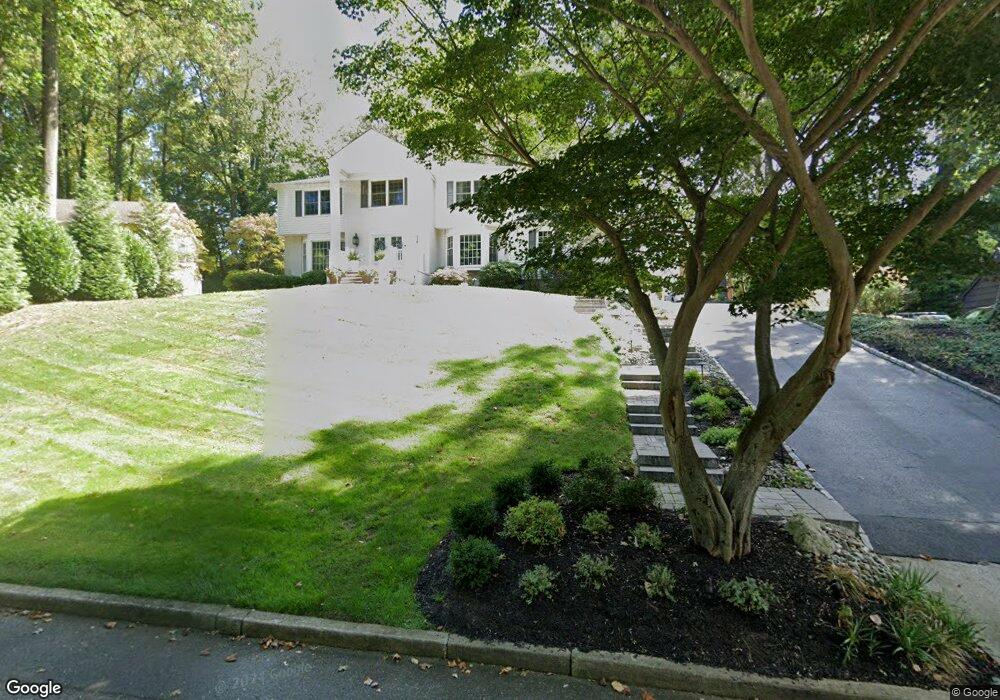
Welcome to this beautifully updated 5-bedroom, 2.5-bath Center Hall Colonial set on a prestigious street in the desirable Oak Hill section of Middletown Township. A paver front walkway & stairway lead to the inviting entry, where hardwood floors, crown molding, & a marble fireplace set the tone. The newly renovated kitchen is the heart of the home, featuring quartz countertops, stainless steel appliances, a bar area with wine fridge and a touchless faucet-perfect for everyday living and entertaining. The primary suite offers a spa-like bath with heated floors, marble tile, & a rainfall shower. Step outside and enjoy a professionally landscaped yard featuring a 3-level paver patio, gazebo with mosquito netting and a 7-person saltwater tub. Convenient to shopping, trains & Garden State Pkwy.
Last Agent to Sell the Property
O'Brien Realty, LLC License #1007851 Listed on: 03/12/2026
Last Buyer's Agent
Michael Gruosso
Berkshire Hathaway HomeServices Fox & Roach - Perrineville
We collect this data history from publicly available records. To have your information removed, we recommend requesting removal directly through your county’s website.
We collect this data history from publicly available records. To have your information removed, we recommend requesting removal directly through your county’s website.
| Date | Type | Sale Price | Title Company |
|---|---|---|---|
| Deed | $1,500,000 | Two River Title | |
| Deed | $405,000 | -- |
We collect this data history from publicly available records. To have your information removed, we recommend requesting removal directly through your county’s website.
| Date | Status | Loan Amount | Loan Type |
|---|---|---|---|
| Open | $1,200,000 | New Conventional | |
| Previous Owner | $364,500 | No Value Available |
We collect this data history from publicly available records. To have your information removed, we recommend requesting removal directly through your county’s website.
| Date | Event | Price | List to Sale | Price per Sq Ft |
|---|---|---|---|---|
| 04/30/2026 04/30/26 | Sold | $1,500,000 | 0.0% | $435 / Sq Ft |
| 03/20/2026 03/20/26 | Pending | -- | -- | -- |
| 03/12/2026 03/12/26 | For Sale | $1,499,999 | -- | $435 / Sq Ft |
We collect this data history from publicly available records. To have your information removed, we recommend requesting removal directly through your county’s website.
| Year | Tax Paid | Tax Assessment Tax Assessment Total Assessment is a certain percentage of the fair market value that is determined by local assessors to be the total taxable value of land and additions on the property. | Land | Improvement |
|---|---|---|---|---|
| 2025 | $18,008 | $1,190,600 | $495,600 | $695,000 |
| 2024 | $17,627 | $1,094,700 | $426,500 | $668,200 |
| 2023 | $17,627 | $1,014,200 | $397,600 | $616,600 |
| 2022 | $16,117 | $853,200 | $266,100 | $587,100 |
| 2021 | $16,117 | $777,500 | $255,300 | $522,200 |
| 2020 | $16,050 | $750,700 | $240,300 | $510,400 |
| 2019 | $15,791 | $747,700 | $240,300 | $507,400 |
| 2018 | $14,931 | $689,000 | $240,300 | $448,700 |
| 2017 | $14,462 | $680,900 | $240,300 | $440,600 |
| 2016 | $14,806 | $694,800 | $265,300 | $429,500 |
| 2015 | $14,266 | $667,900 | $245,300 | $422,600 |
| 2014 | $13,605 | $621,500 | $235,300 | $386,200 |
Seller's Agent in 2026
Kerrin O'Brien
O'Brien Realty, LLC
(732) 320-6999
10 in this area
205 Total Sales
M
Buyer's Agent in 2026
Michael Gruosso
Berkshire Hathaway HomeServices Fox & Roach - Perrineville
Source: MOREMLS (Monmouth Ocean Regional REALTORS®)
MLS Number: 22606300
APN: 32-00846-0000-00003
Disclaimer: Certain information contained herein is derived from information provided by parties other than Homes.com. All information provided is deemed reliable, but is not guaranteed to be accurate and should be independently verified.
![]() IDX information is provided exclusively for personal, non-commercial use, and may not be used for any purpose other than to identify prospective properties consumers may be interested in purchasing.
IDX information is provided exclusively for personal, non-commercial use, and may not be used for any purpose other than to identify prospective properties consumers may be interested in purchasing.
Information is deemed reliable but not guaranteed.
Ask me questions while you tour the home.