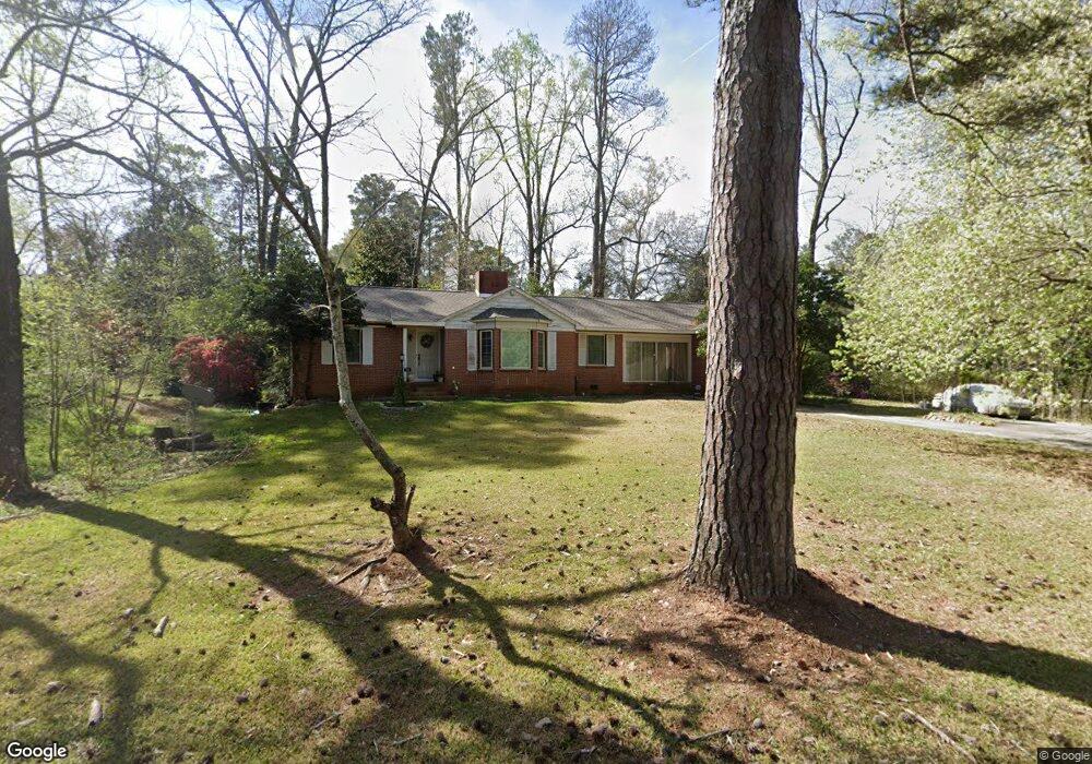
771 Blanton Blvd Macon, GA 31210
Estimated Value: $189,000 - $228,000
3
Beds
2
Baths
1,640
Sq Ft
$122/Sq Ft
Est. Value
About This Home
This home is located at 771 Blanton Blvd, Macon, GA 31210 and is currently estimated at $200,287, approximately $122 per square foot. 771 Blanton Blvd is a home located in Bibb County with nearby schools including Lane Elementary School, Howard Middle School, and Howard High School.
Ownership History
Date
Name
Owned For
Owner Type
Purchase Details
Closed on
Jan 31, 2011
Sold by
Mccreanor Philip T
Bought by
Mccreanor Philip T and Mccreanor Anita
Current Estimated Value
Home Financials for this Owner
Home Financials are based on the most recent Mortgage that was taken out on this home.
Original Mortgage
$66,000
Outstanding Balance
$1,532
Interest Rate
4.79%
Mortgage Type
New Conventional
Estimated Equity
$198,755
Purchase Details
Closed on
Mar 16, 2000
Bought by
Mccreanor Philip T
Create a Home Valuation Report for This Property
The Home Valuation Report is an in-depth analysis detailing your home's value as well as a comparison with similar homes in the area
Purchase History
| Date | Buyer | Sale Price | Title Company |
|---|---|---|---|
| Mccreanor Philip T | -- | None Available | |
| Mccreanor Philip T | $87,000 | -- |
Source: Public Records
Mortgage History
| Date | Status | Borrower | Loan Amount |
|---|---|---|---|
| Open | Mccreanor Philip T | $66,000 |
Source: Public Records
Tax History
| Year | Tax Paid | Tax Assessment Tax Assessment Total Assessment is a certain percentage of the fair market value that is determined by local assessors to be the total taxable value of land and additions on the property. | Land | Improvement |
|---|---|---|---|---|
| 2025 | $1,401 | $63,995 | $20,280 | $43,715 |
| 2024 | $1,419 | $62,886 | $20,280 | $42,606 |
| 2023 | $821 | $57,341 | $20,280 | $37,061 |
| 2022 | $1,516 | $50,801 | $9,472 | $41,329 |
| 2021 | $1,515 | $46,856 | $9,093 | $37,763 |
| 2020 | $1,473 | $44,949 | $8,714 | $36,235 |
| 2019 | $1,221 | $38,203 | $8,335 | $29,868 |
| 2018 | $2,051 | $38,203 | $8,335 | $29,868 |
| 2017 | $1,100 | $36,349 | $8,335 | $28,014 |
| 2016 | $1,015 | $36,348 | $8,335 | $28,014 |
| 2015 | $1,438 | $36,348 | $8,335 | $28,014 |
| 2014 | $1,747 | $37,106 | $9,093 | $28,014 |
Source: Public Records
Map
Nearby Homes
- 790 Wimbish Rd
- 770 Windsor Rd
- 715 Gay Dr
- 610 Chastain Place
- 567 Glencove Dr
- 810 Willow Creek Dr Unit 810
- 2969 Victoria Cir
- 726 Willow Creek Dr
- 654 Willow Creek Dr
- 840 Balim Ct
- 2945 Crestline Dr
- 829 Edward Place
- 835 Old Lundy Rd
- 122 Lundy Ct
- 603 Willow Creek Dr
- 615 Willow Creek Dr
- 946 Laurel Oak Ct
- 125 N Laura Ann Ct
- 1024 Normandy Rd
- 2925 Thornwood Dr
- 763 Blanton Blvd
- 763 Blanton Blvd Unit 7475 Bentley Drive
- 775 Blanton Blvd
- 774 Blanton Blvd
- 757 Blanton Blvd
- 770 Blanton Blvd
- 758 Wimbish Rd
- 788 Gay Dr
- 752 Wimbish Rd
- 795 Gay Dr
- 754 Blanton Blvd
- 748 Wimbish Rd
- 770 Wimbish Rd
- 970 Dogwood Cir
- 782 Gay Dr
- 749 Blanton Blvd
- 787 Gay Dr
- 748 Blanton Blvd
- 782 Blanton Blvd
- 744 Wimbish Rd
Your Personal Tour Guide
Ask me questions while you tour the home.