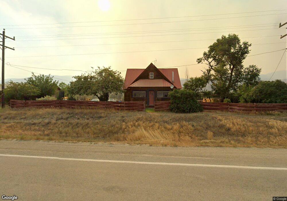
78 Highway 93 N Salmon, ID 83467
Estimated Value: $258,034 - $351,000
2
Beds
1
Bath
1,860
Sq Ft
$164/Sq Ft
Est. Value
About This Home
This home is located at 78 Highway 93 N, Salmon, ID 83467 and is currently estimated at $304,259, approximately $163 per square foot. 78 Highway 93 N is a home located in Lemhi County with nearby schools including Salmon Pioneer Primary School, Salmon Jr./Sr. High School, and Fern-Waters Public Charter School.
Ownership History
Date
Name
Owned For
Owner Type
Purchase Details
Closed on
Sep 15, 2023
Sold by
Raymond Beverly Cockrell Family Living T
Bought by
Kc Ranch Llc
Current Estimated Value
Purchase Details
Closed on
Feb 15, 2022
Sold by
Still Michael S and Still Tina
Bought by
Mcnamara Kelsey Elizabeth and Mcnamara Eric Michael
Home Financials for this Owner
Home Financials are based on the most recent Mortgage that was taken out on this home.
Original Mortgage
$156,000
Interest Rate
3.69%
Create a Home Valuation Report for This Property
The Home Valuation Report is an in-depth analysis detailing your home's value as well as a comparison with similar homes in the area
Home Values in the Area
Average Home Value in this Area
Purchase History
| Date | Buyer | Sale Price | Title Company |
|---|---|---|---|
| Kc Ranch Llc | -- | None Listed On Document | |
| Mcnamara Kelsey Elizabeth | -- | Alliance Title |
Source: Public Records
Mortgage History
| Date | Status | Borrower | Loan Amount |
|---|---|---|---|
| Previous Owner | Mcnamara Kelsey Elizabeth | $156,000 |
Source: Public Records
Tax History
| Year | Tax Paid | Tax Assessment Tax Assessment Total Assessment is a certain percentage of the fair market value that is determined by local assessors to be the total taxable value of land and additions on the property. | Land | Improvement |
|---|---|---|---|---|
| 2025 | $678 | $166,198 | $14,432 | $151,766 |
| 2024 | $507 | $166,198 | $14,432 | $151,766 |
| 2023 | $469 | $166,198 | $14,432 | $151,766 |
| 2022 | $498 | $166,198 | $14,432 | $151,766 |
| 2021 | $367 | $79,899 | $14,432 | $65,467 |
| 2020 | $381 | $79,899 | $14,432 | $65,467 |
| 2019 | $373 | $79,899 | $14,432 | $65,467 |
| 2018 | $431 | $94,364 | $14,432 | $79,932 |
| 2017 | $443 | $94,364 | $14,432 | $79,932 |
| 2016 | $391 | $76,103 | $14,432 | $61,671 |
| 2013 | $406 | $76,103 | $14,432 | $61,671 |
| 2011 | $406 | $89,323 | $13,526 | $75,797 |
Source: Public Records
Map
Nearby Homes
- 113 U S 93
- 8 Goodman Ln
- TBD Broadway Cir
- 605 Neyman St
- 409 Lombard St
- 804 Cleveland Ave
- TBD Blackrock Rd
- 114 Neyman St
- 322 N Saint Charles St
- 117 Lafayette Ave
- 1104 Taft Ave
- 704 13th St
- 405 Washington St
- Lot 1 Old Leesburg Rd
- 1307 Taft Ave
- LOT 2 Old Leesburg Rd
- LOT 4 Old Leesburg Rd
- 101 S 9th Rd
- 111 10th St
- 1505 Taft Ave
Your Personal Tour Guide
Ask me questions while you tour the home.