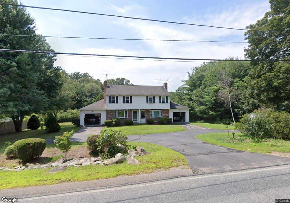
78 Locust St Bellingham, MA 02019
Estimated Value: $390,000 - $709,000
About This Home
This home is located at 78 Locust St, Bellingham, MA 02019 and is currently estimated at $552,365, approximately $488 per square foot. 78 Locust St is a home located in Norfolk County with nearby schools including Joseph F. DiPietro Elementary, Bellingham High School, and Benjamin Franklin Classical Charter Public School.
Ownership History
We collect this data history from publicly available records. To have your information removed, we recommend requesting removal directly through your county’s website.
Purchase Details
Home Financials for this Owner
Home Financials are based on the most recent Mortgage that was taken out on this home.Home Values in the Area
Average Home Value in this Area
Purchase History
We collect this data history from publicly available records. To have your information removed, we recommend requesting removal directly through your county’s website.
| Date | Buyer | Sale Price | Title Company |
|---|---|---|---|
| $119,000 | -- |
Mortgage History
We collect this data history from publicly available records. To have your information removed, we recommend requesting removal directly through your county’s website.
| Date | Status | Borrower | Loan Amount |
|---|---|---|---|
| Closed | $79,200 | ||
| Closed | $95,200 |
Tax History
We collect this data history from publicly available records. To have your information removed, we recommend requesting removal directly through your county’s website.
| Year | Tax Paid | Tax Assessment Tax Assessment Total Assessment is a certain percentage of the fair market value that is determined by local assessors to be the total taxable value of land and additions on the property. | Land | Improvement |
|---|---|---|---|---|
| 2025 | $3,674 | $292,500 | $0 | $292,500 |
| 2024 | $3,659 | $284,500 | $0 | $284,500 |
| 2023 | $3,216 | $246,400 | $0 | $246,400 |
| 2022 | $3,155 | $224,100 | $0 | $224,100 |
| 2021 | $3,200 | $222,100 | $0 | $222,100 |
| 2020 | $3,054 | $214,800 | $0 | $214,800 |
| 2019 | $2,804 | $197,300 | $0 | $197,300 |
| 2018 | $2,840 | $197,100 | $0 | $197,100 |
| 2017 | $2,746 | $191,500 | $0 | $191,500 |
| 2016 | $2,534 | $177,300 | $0 | $177,300 |
| 2015 | $2,527 | $177,300 | $0 | $177,300 |
| 2014 | $2,623 | $178,900 | $0 | $178,900 |
Map
- 4 Cypress Cir Unit 4
- 1250 Pulaski Blvd
- 25 Palmetto Dr Unit 25
- 21 Palmetto Dr Unit 21
- 15 Ridge Rd
- 238 Lake St
- 12 Priscilla Ave
- 273 Lake St
- 31 Cassandra Ave Unit 31
- 900 Washington St Lot 2
- 219 Dawn Blvd
- 3 Taylor Rd
- 20 Nature View Dr
- 2320 Diamond Hill Rd
- 50 Farm Hill Rd
- 61 Pine Grove Ave
- 25 Pine Swamp Rd
- 31 Fox Run Rd
- 39 Opal Cir
- 550 Pulaski Blvd
- 76 Locust St
- 74 Locust St
- 72 Locust St
- 80 Locust St
- 73 Locust St
- 4 Sidney Ln
- 1 Brookfield Ln
- 81 Locust St
- 0 2a Sidney Ln Unit 50485178
- 0 1a Sidney Ln Unit 50485177
- 1 Brookfield Ln
- 0 6a Sidney Ln Unit 50485182
- 1 Brookfield Rd
- 8 Sidney Ln
- 69 Locust St
- 5 Brookfield Ln
- 77 Locust St
- 12 Sidney Ln
- 86 Locust St
- 84 Locust St
Ask me questions while you tour the home.