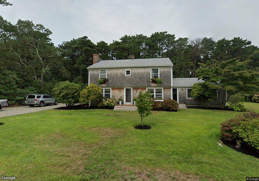
780 Governor Prence Rd Eastham, MA 02642
Estimated Value: $840,020 - $948,000
5
Beds
3
Baths
2,532
Sq Ft
$345/Sq Ft
Est. Value
About This Home
This home is located at 780 Governor Prence Rd, Eastham, MA 02642 and is currently estimated at $874,755, approximately $345 per square foot. 780 Governor Prence Rd is a home located in Barnstable County with nearby schools including Eastham Elementary School, Nauset Regional Middle School, and Nauset Regional High School.
Ownership History
Date
Name
Owned For
Owner Type
Purchase Details
Closed on
Jan 20, 2011
Sold by
Clarkston State Bk
Bought by
Cannata Paul D and Cannata Laura B
Current Estimated Value
Home Financials for this Owner
Home Financials are based on the most recent Mortgage that was taken out on this home.
Original Mortgage
$286,000
Outstanding Balance
$193,488
Interest Rate
4.62%
Mortgage Type
Purchase Money Mortgage
Estimated Equity
$681,267
Purchase Details
Closed on
Jun 3, 2010
Sold by
Wilson Jacqueline Kiss
Bought by
Clarkston State Bk
Purchase Details
Closed on
Nov 1, 1999
Sold by
Greim Beverly R
Bought by
Wilson Charles J and Wilson Jacqueline K
Create a Home Valuation Report for This Property
The Home Valuation Report is an in-depth analysis detailing your home's value as well as a comparison with similar homes in the area
Home Values in the Area
Average Home Value in this Area
Purchase History
| Date | Buyer | Sale Price | Title Company |
|---|---|---|---|
| Cannata Paul D | $358,000 | -- | |
| Clarkston State Bk | $425,000 | -- | |
| Wilson Charles J | $240,000 | -- |
Source: Public Records
Mortgage History
| Date | Status | Borrower | Loan Amount |
|---|---|---|---|
| Open | Wilson Charles J | $286,000 | |
| Previous Owner | Wilson Charles J | $73,000 |
Source: Public Records
Tax History
| Year | Tax Paid | Tax Assessment Tax Assessment Total Assessment is a certain percentage of the fair market value that is determined by local assessors to be the total taxable value of land and additions on the property. | Land | Improvement |
|---|---|---|---|---|
| 2025 | $5,385 | $698,500 | $210,800 | $487,700 |
| 2024 | $4,755 | $678,300 | $204,700 | $473,600 |
| 2023 | $4,221 | $583,000 | $170,600 | $412,400 |
| 2022 | $3,833 | $446,700 | $152,300 | $294,400 |
| 2021 | $3,726 | $405,900 | $138,400 | $267,500 |
| 2020 | $3,416 | $391,700 | $141,300 | $250,400 |
| 2019 | $3,138 | $380,400 | $137,200 | $243,200 |
| 2018 | $3,084 | $369,400 | $133,200 | $236,200 |
| 2017 | $2,861 | $362,200 | $130,600 | $231,600 |
| 2016 | $2,864 | $385,000 | $145,100 | $239,900 |
| 2015 | $2,623 | $369,500 | $142,200 | $227,300 |
Source: Public Records
Map
Nearby Homes
- 330 Hay Rd
- 20 Stone Ct
- 1061 State Hwy Unit 4
- 1061 State Hwy Unit 1061
- 655 Herring Brook Rd
- 10 Cartway N
- 1975 State Hwy Unit 9
- 25 Twin Rocks Dr
- 704 State Hwy
- 20 Kittiwake Ln
- 60 Smith Heights Way
- 320 State Hwy
- 40 Bayview Rd
- 59 Bridge Rd
- 46 Freeman Ln
- 480 Dyer Prince Rd
- 339 Dyer Prince Rd
- 21 Locust Rd Unit 21
- 181 Rock Harbor Rd
- 343 Tonset Rd
- 785 Governor Prence Rd
- 800 Governor Prence Rd
- 745 Governor Prence Rd
- 24 Pilgrim Ln
- 26 Pilgrim Ln
- 830 Governor Prence Rd
- 725 Governor Prence Rd
- 815 Governor Prence Rd
- 22 Pilgrim Ln
- 700 Governor Prence Rd
- 1226-R Bridge Rd
- 0 Pilgrim
- 20 Gull Ln
- 100 Limerick Way
- 835 Governor Prence Rd
- 20 Pilgrim Ln
- 10 Gull Ln
- 25 Pilgrim Ln
- 95 Limerick Way
- 23 Pilgrim Ln
Your Personal Tour Guide
Ask me questions while you tour the home.