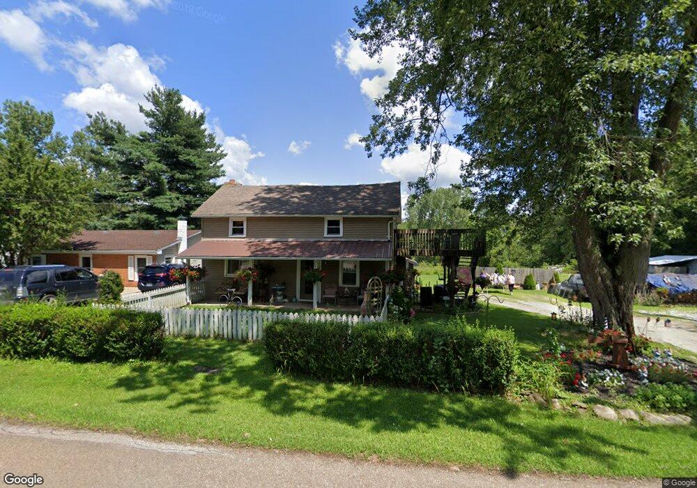
783 Hull Rd Mansfield, OH 44903
Estimated Value: $116,000 - $180,000
3
Beds
1
Bath
1,106
Sq Ft
$134/Sq Ft
Est. Value
About This Home
This home is located at 783 Hull Rd, Mansfield, OH 44903 and is currently estimated at $148,445, approximately $134 per square foot. 783 Hull Rd is a home located in Richland County with nearby schools including Madison High School, St. Peter's Elementary/Montessori School, and Temple-Christian School.
Ownership History
Date
Name
Owned For
Owner Type
Purchase Details
Closed on
Dec 10, 2004
Sold by
Holston Patricia
Bought by
Utt Pamela
Current Estimated Value
Home Financials for this Owner
Home Financials are based on the most recent Mortgage that was taken out on this home.
Original Mortgage
$28,000
Interest Rate
5.19%
Mortgage Type
Purchase Money Mortgage
Create a Home Valuation Report for This Property
The Home Valuation Report is an in-depth analysis detailing your home's value as well as a comparison with similar homes in the area
Home Values in the Area
Average Home Value in this Area
Purchase History
| Date | Buyer | Sale Price | Title Company |
|---|---|---|---|
| Utt Pamela | $35,000 | -- |
Source: Public Records
Mortgage History
| Date | Status | Borrower | Loan Amount |
|---|---|---|---|
| Closed | Utt Pamela | $28,000 |
Source: Public Records
Tax History
| Year | Tax Paid | Tax Assessment Tax Assessment Total Assessment is a certain percentage of the fair market value that is determined by local assessors to be the total taxable value of land and additions on the property. | Land | Improvement |
|---|---|---|---|---|
| 2025 | $723 | $25,630 | $11,090 | $14,540 |
| 2024 | $723 | $25,630 | $11,090 | $14,540 |
| 2023 | $768 | $25,630 | $11,090 | $14,540 |
| 2022 | $1,118 | $20,490 | $9,910 | $10,580 |
| 2021 | $1,118 | $20,490 | $9,910 | $10,580 |
| 2020 | $1,127 | $20,490 | $9,910 | $10,580 |
| 2019 | $1,074 | $17,370 | $8,400 | $8,970 |
| 2018 | $1,004 | $17,370 | $8,400 | $8,970 |
| 2017 | $837 | $17,370 | $8,400 | $8,970 |
| 2016 | $691 | $11,800 | $7,980 | $3,820 |
| 2015 | $691 | $11,800 | $7,980 | $3,820 |
| 2014 | $657 | $11,800 | $7,980 | $3,820 |
| 2012 | $326 | $12,420 | $8,400 | $4,020 |
Source: Public Records
Map
Nearby Homes
- 1715 Mansfield Lucas Rd
- 794 Mansfield Washington Rd
- 625 Mansfield Lucas Rd
- 851 Danwood Ave
- 474 Brenda Dr
- 292 Greenlee Rd
- 1200 S Main St
- 138 Cliffbrook Dr
- 61 Mccullough Blvd Unit 45
- 2011 Ohio 39
- 0 State Route 39 & I-71 Southeast Quadrant
- 50 Lilac Ct E
- 392 Gem Ave
- 0 State Route 39 & I-71 Northeast Quadrant
- 83 Mccullough Blvd Unit 52
- 33 Rambleside Dr
- 571 Luther St
- 86 Sherbrook Rd
- 475 Beethoven St
- 104 Elmridge Rd
- 779 Hull Rd
- 771 Hull Rd
- 822 Hull Rd
- 834 Hull Rd
- 742 Hull Rd
- 762 Hull Rd
- 844 Hull Rd
- 1101 Mansfield Washington Rd
- 720 Hull Rd
- 872 Hull Rd
- 1584 Mansfield Lucas Rd
- 696 Hull Rd
- 0 Mansfield Lucas Rd Unit 500459
- 0 Mansfield Lucas Rd Unit 220197
- 0 Mansfield Lucas Rd Unit 100214
- 0 Mansfield Lucas Rd Unit 9025334
- 0 Mansfield Lucas Rd Unit 9038577
- 2350 Mansfield Lucas Rd
- 0 Mansfield Lucas Rd Unit 9046246
- 0 Mansfield Lucas Rd
Your Personal Tour Guide
Ask me questions while you tour the home.