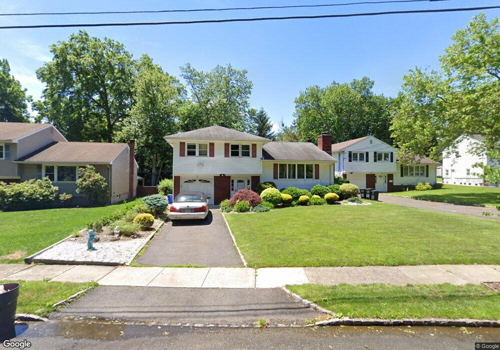
79 Beverly Rd Springfield, NJ 07081
Estimated Value: $543,000 - $749,000
Studio
--
Bath
1,866
Sq Ft
$349/Sq Ft
Est. Value
About This Home
This home is located at 79 Beverly Rd, Springfield, NJ 07081 and is currently estimated at $651,852, approximately $349 per square foot. 79 Beverly Rd is a home located in Union County with nearby schools including Jonathan Dayton High School and St James The Apostle School.
Ownership History
Date
Name
Owned For
Owner Type
Purchase Details
Closed on
Jan 18, 2024
Sold by
Lacobucci Ronald J
Bought by
Murray Michael Owen and Avella Maria
Current Estimated Value
Home Financials for this Owner
Home Financials are based on the most recent Mortgage that was taken out on this home.
Original Mortgage
$468,000
Outstanding Balance
$459,933
Interest Rate
7.03%
Mortgage Type
New Conventional
Estimated Equity
$191,919
Create a Home Valuation Report for This Property
The Home Valuation Report is an in-depth analysis detailing your home's value as well as a comparison with similar homes in the area
Home Values in the Area
Average Home Value in this Area
Purchase History
| Date | Buyer | Sale Price | Title Company |
|---|---|---|---|
| Murray Michael Owen | $585,000 | Acres Land Title | |
| Murray Michael Owen | $585,000 | Acres Land Title |
Source: Public Records
Mortgage History
| Date | Status | Borrower | Loan Amount |
|---|---|---|---|
| Open | Murray Michael Owen | $468,000 | |
| Closed | Murray Michael Owen | $468,000 |
Source: Public Records
Tax History
| Year | Tax Paid | Tax Assessment Tax Assessment Total Assessment is a certain percentage of the fair market value that is determined by local assessors to be the total taxable value of land and additions on the property. | Land | Improvement |
|---|---|---|---|---|
| 2025 | $12,310 | $518,300 | $214,600 | $303,700 |
| 2024 | $12,107 | $518,300 | $214,600 | $303,700 |
| 2023 | $12,107 | $518,300 | $214,600 | $303,700 |
| 2022 | $11,242 | $518,300 | $214,600 | $303,700 |
| 2021 | $11,220 | $150,700 | $63,400 | $87,300 |
| 2020 | $11,045 | $150,700 | $63,400 | $87,300 |
| 2019 | $10,896 | $150,700 | $63,400 | $87,300 |
| 2018 | $10,700 | $150,700 | $63,400 | $87,300 |
| 2017 | $10,406 | $150,700 | $63,400 | $87,300 |
| 2016 | $10,204 | $150,700 | $63,400 | $87,300 |
| 2015 | $10,085 | $150,700 | $63,400 | $87,300 |
| 2014 | $9,895 | $150,700 | $63,400 | $87,300 |
Source: Public Records
Map
Nearby Homes
- 56 Diven St
- 23 Diven St
- 167 Newbrook Ln
- 32 Ruby St
- 122 Kipling Ave
- 559 S Springfield Ave Unit 559
- 171 S Springfield Ave
- 20 Kew Dr
- 20 Archbridge Ln
- 294 Mountain Ave
- 366 Rolling Rock Rd
- 14 Eton Place
- 28 Elmwood Rd
- 10 Tree Top Dr
- 1060 Sunny Slope Dr
- 2 S Audlen Terrace
- 29 Manitou Cir
- 427 Summit Rd
- 423 Summit Rd
- 1098 Sunny Slope Dr
- 75 Beverly Rd
- 83 Beverly Rd
- 71 Beverly Rd
- 87 Beverly Rd
- 220 Hillside Ave
- 210 Hillside Ave
- 91 Beverly Rd
- 234 Hillside Ave
- 95 Beverly Rd
- 206 Hillside Ave
- 236 Hillside Ave
- 63 Beverly Rd
- 240 Hillside Ave
- 202 Hillside Ave
- 12 Kimberly Ct
- 10 Kimberly Ct
- 213 Hillside Ave
- 14 Kimberly Ct
- 244 Hillside Ave
- 53 Beverly Rd
Your Personal Tour Guide
Ask me questions while you tour the home.