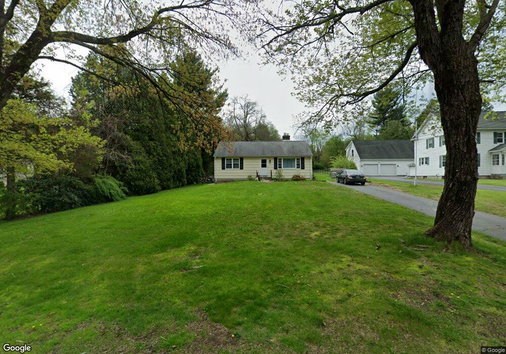
79 Upper Bogue Rd Harwinton, CT 06791
Estimated Value: $272,000 - $309,000
2
Beds
1
Bath
1,064
Sq Ft
$274/Sq Ft
Est. Value
About This Home
This home is located at 79 Upper Bogue Rd, Harwinton, CT 06791 and is currently estimated at $291,511, approximately $273 per square foot. 79 Upper Bogue Rd is a home located in Litchfield County with nearby schools including Harwinton Consolidated School, Har-Bur Middle School, and Lewis S. Mills High School.
Ownership History
Date
Name
Owned For
Owner Type
Purchase Details
Closed on
Aug 13, 2013
Sold by
Fresh Look Homes Llc
Bought by
Baker Jeremy T and Baker Kendall A
Current Estimated Value
Home Financials for this Owner
Home Financials are based on the most recent Mortgage that was taken out on this home.
Original Mortgage
$163,265
Outstanding Balance
$121,333
Interest Rate
4.45%
Estimated Equity
$170,178
Create a Home Valuation Report for This Property
The Home Valuation Report is an in-depth analysis detailing your home's value as well as a comparison with similar homes in the area
Home Values in the Area
Average Home Value in this Area
Purchase History
| Date | Buyer | Sale Price | Title Company |
|---|---|---|---|
| Baker Jeremy T | $160,000 | -- | |
| Baker Jeremy T | $160,000 | -- |
Source: Public Records
Mortgage History
| Date | Status | Borrower | Loan Amount |
|---|---|---|---|
| Open | Baker Jeremy T | $163,265 | |
| Closed | Baker Jeremy T | $163,265 | |
| Previous Owner | Baker Jeremy T | $25,000 | |
| Previous Owner | Baker Jeremy T | $82,000 |
Source: Public Records
Tax History
| Year | Tax Paid | Tax Assessment Tax Assessment Total Assessment is a certain percentage of the fair market value that is determined by local assessors to be the total taxable value of land and additions on the property. | Land | Improvement |
|---|---|---|---|---|
| 2025 | $3,648 | $158,610 | $57,810 | $100,800 |
| 2024 | $3,632 | $158,610 | $57,810 | $100,800 |
| 2023 | $3,384 | $115,900 | $41,290 | $74,610 |
| 2022 | $3,303 | $115,900 | $41,290 | $74,610 |
| 2021 | $3,326 | $115,900 | $41,290 | $74,610 |
| 2020 | $3,245 | $115,900 | $41,290 | $74,610 |
| 2019 | $3,245 | $115,900 | $41,290 | $74,610 |
| 2018 | $3,135 | $111,970 | $43,830 | $68,140 |
| 2017 | $3,113 | $111,970 | $43,830 | $68,140 |
| 2016 | $3,113 | $111,970 | $43,830 | $68,140 |
| 2015 | $3,057 | $111,970 | $43,830 | $68,140 |
| 2014 | $3,012 | $111,970 | $43,830 | $68,140 |
Source: Public Records
Map
Nearby Homes
- 68 Thomaston Rd
- 0 Clearview Ave Unit 24158105
- 505 Harwinton Ave Unit 20
- 152 Davis Rd
- 112 Linden St
- 364 Park Ave
- 71 Arthur St Unit 1
- 14 Hannah Way
- 23 Hannah Way
- 83 Birge St
- 29 Elton St
- 151 Highview Dr
- 264 S Main St
- Lot 2 Birch Hill Rd
- 67 E Litchfield Rd S
- 21 Sunrise Dr
- 185 Oak Meadow Ln
- 65 Oak Meadow Ln Unit 65
- 19 Harwinton Ave
- 68 Wilson Ave Unit 103
- 79 Bogue Rd
- 83 Bogue Rd
- 82 Upper Bogue Rd
- 89 Upper Bogue Rd
- 89 Bogue Rd
- 83 Upper Bogue Rd
- 93 Upper Bogue Rd
- 92 Upper Bogue Rd
- 75 Upper Bogue Rd
- 96 Upper Bogue Rd
- 24 Maple Dr
- 68 Upper Bogue Rd
- 99 Upper Bogue Rd
- 99 Bogue Rd
- 103 Upper Bogue Rd
- 11 Community Rd
- 13 Community Rd
- 11 Sunny Ln
- 3 Sunny Ln
- 25 Maple Dr
Your Personal Tour Guide
Ask me questions while you tour the home.