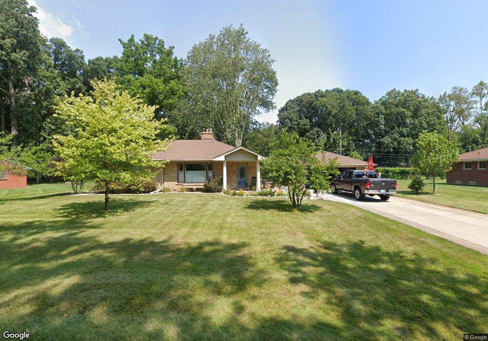
7958 Coventry Ave Grosse Ile, MI 48138
Estimated Value: $296,000 - $359,000
3
Beds
2
Baths
1,600
Sq Ft
$197/Sq Ft
Est. Value
About This Home
This home is located at 7958 Coventry Ave, Grosse Ile, MI 48138 and is currently estimated at $314,626, approximately $196 per square foot. 7958 Coventry Ave is a home located in Wayne County with nearby schools including St. Cyprian Elementary School.
Ownership History
Date
Name
Owned For
Owner Type
Purchase Details
Closed on
Dec 16, 2024
Sold by
Meyring Gregory J
Bought by
Gregory J Meyring Revocable Living Trust and Meyring
Current Estimated Value
Purchase Details
Closed on
Jan 24, 2011
Sold by
Oflynn Kathleen and Estate Of Agnes Hutchinson
Bought by
Meyring Gregory J
Create a Home Valuation Report for This Property
The Home Valuation Report is an in-depth analysis detailing your home's value as well as a comparison with similar homes in the area
Home Values in the Area
Average Home Value in this Area
Purchase History
We collect this data history from publicly available records. To have your information removed, we recommend requesting removal directly through your county’s website.
| Date | Buyer | Sale Price | Title Company |
|---|---|---|---|
| Gregory J Meyring Revocable Living Trust | -- | None Listed On Document | |
| Meyring Gregory J | -- | None Listed On Document | |
| Meyring Gregory J | $115,000 | Michigan Title Ins Agcy Inc |
Source: Public Records
Tax History
| Year | Tax Paid | Tax Assessment Tax Assessment Total Assessment is a certain percentage of the fair market value that is determined by local assessors to be the total taxable value of land and additions on the property. | Land | Improvement |
|---|---|---|---|---|
| 2025 | $1,562 | $130,800 | $0 | $0 |
| 2024 | $1,520 | $121,700 | $0 | $0 |
| 2023 | $1,739 | $111,600 | $0 | $0 |
| 2022 | $4,048 | $102,600 | $0 | $0 |
| 2021 | $3,872 | $101,100 | $0 | $0 |
| 2019 | $3,840 | $88,700 | $0 | $0 |
| 2018 | $1,651 | $91,700 | $0 | $0 |
| 2017 | $4,264 | $88,600 | $0 | $0 |
| 2016 | $3,774 | $88,300 | $0 | $0 |
| 2015 | $8,037 | $81,600 | $0 | $0 |
| 2013 | $7,970 | $81,100 | $0 | $0 |
| 2012 | $1,685 | $78,600 | $28,000 | $50,600 |
Source: Public Records
Map
Nearby Homes
- 21527 Parke Ln
- 21420 Salisbury Ave
- 21599 Parke Ln
- 22 Potowatomi Dr
- 21 Potowatomi Dr
- 25 Potowatomi Dr
- 8480 Hampton Rd
- 21071 Thorofare Rd
- 21879 Canterbury Ave
- 8487 Sherwood Dr Unit 17
- 8946 Potowatomi Dr
- 21918 Knudsen Dr
- 9355 Highland Dr
- 129 Meridian Rd
- 9447 Whitall Ln
- 9281 Island Dr
- 19580 Parke Ln
- 22827 Meridian Rd
- 7611 Ferry Rd
- 9555 Island Dr
- 7934 Coventry Ave
- 7982 Coventry Ave
- 7959 Bournemouth Ave
- 7935 Bournemouth Ave
- 7983 Bournemouth Ave
- 7961 Coventry Ave
- 7937 Coventry Ave
- 8006 Coventry Ave
- 7985 Coventry Ave
- 7911 Bournemouth Ave
- 8007 Bournemouth Ave
- 7915 Coventry Ave
- 7960 Church Rd
- 7954 Bournemouth Ave Unit Bldg-Unit
- 7954 Bournemouth Ave
- 7974 Bournemouth Ave
- 8030 Coventry Ave
- 7950 Church Rd
- 7932 Bournemouth Ave
- 7978 Church Rd
Your Personal Tour Guide
Ask me questions while you tour the home.