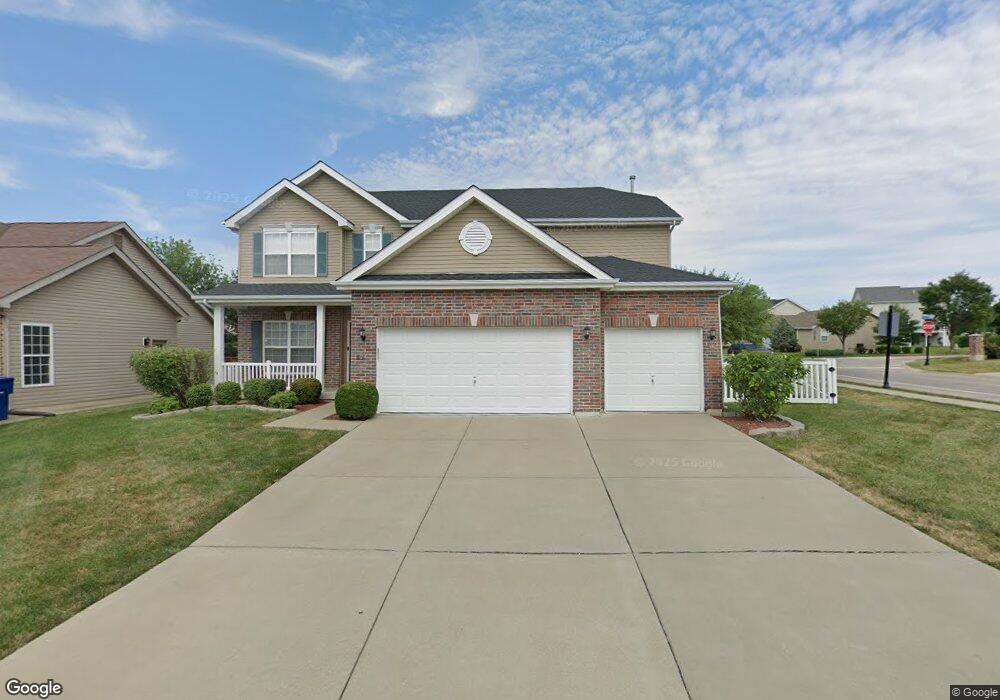
801 Harding St Saint Peters, MO 63376
Estimated Value: $529,735 - $645,000
4
Beds
4
Baths
3,144
Sq Ft
$182/Sq Ft
Est. Value
About This Home
This home is located at 801 Harding St, Saint Peters, MO 63376 and is currently estimated at $573,684, approximately $182 per square foot. 801 Harding St is a home located in St. Charles County with nearby schools including Lewis & Clark Elementary School, Dr. Bernard J. Dubray Middle School, and Fort Zumwalt East High School.
Ownership History
Date
Name
Owned For
Owner Type
Purchase Details
Closed on
Feb 7, 2014
Sold by
Mcbride Bellemeade Llc
Bought by
Taylor Tyler Sumner and Taylor Shana Zarin
Current Estimated Value
Home Financials for this Owner
Home Financials are based on the most recent Mortgage that was taken out on this home.
Original Mortgage
$322,561
Outstanding Balance
$242,474
Interest Rate
4.51%
Mortgage Type
VA
Estimated Equity
$331,210
Purchase Details
Closed on
Oct 2, 2013
Sold by
First Bank
Bought by
Mcbride Bellemeade Llc
Create a Home Valuation Report for This Property
The Home Valuation Report is an in-depth analysis detailing your home's value as well as a comparison with similar homes in the area
Home Values in the Area
Average Home Value in this Area
Purchase History
| Date | Buyer | Sale Price | Title Company |
|---|---|---|---|
| Taylor Tyler Sumner | $315,772 | Dependable Title Llc | |
| Mcbride Bellemeade Llc | -- | Ust |
Source: Public Records
Mortgage History
| Date | Status | Borrower | Loan Amount |
|---|---|---|---|
| Open | Taylor Tyler Sumner | $322,561 |
Source: Public Records
Tax History
| Year | Tax Paid | Tax Assessment Tax Assessment Total Assessment is a certain percentage of the fair market value that is determined by local assessors to be the total taxable value of land and additions on the property. | Land | Improvement |
|---|---|---|---|---|
| 2025 | $6,313 | $95,852 | -- | -- |
| 2024 | $6,313 | $88,901 | -- | -- |
| 2023 | $6,308 | $88,901 | -- | -- |
| 2022 | $5,439 | $71,806 | $0 | $0 |
| 2021 | $5,430 | $71,806 | $0 | $0 |
| 2020 | $5,317 | $68,155 | $0 | $0 |
| 2019 | $5,304 | $68,155 | $0 | $0 |
| 2018 | $5,361 | $66,235 | $0 | $0 |
| 2017 | $5,337 | $66,235 | $0 | $0 |
| 2016 | $4,845 | $59,997 | $0 | $0 |
| 2015 | $4,534 | $59,997 | $0 | $0 |
| 2014 | $3,908 | $6,080 | $0 | $0 |
Source: Public Records
Map
Nearby Homes
- 1232 Cashmere Ln
- 44 Kimberly Ln
- 832 Du Pre Ct
- 47 Julie Ln
- 547 Ryehill Dr
- 563 Ryehill Dr
- 1313 Colby Dr
- 138 Rhythm Point Dr
- 525 Ryehill Dr
- 1 Brookmont @ Ryehill Manor
- 27 Glenna Dr
- 1135 Carrington Dr
- 729 N Yosemite Ct
- 105 Jane Dr
- 116 Willott Square Dr
- 2032 Belltower Dr
- 22 Shadow Creek Dr
- 1152 Carrington Dr
- 213 Candice Way
- 515 Starwood Dr Unit 3
- 803 Harding St
- 236 Bellemeade Dr
- 805 Harding St
- 241 Bellemeade Dr
- 238 Bellemeade Dr
- 804 Harding St
- 502 Selene St
- 243 Bellemeade Dr
- 240TBB Bellemeade Unit 102C
- 240 Bellemeade Dr
- 242 Bellemeade Dr
- 242 Bellemeade Dr Unit 101
- 504 Selene St Unit 34
- 504 Selene St
- 807 Harding St
- 807 Harding St Unit 4C
- 806 Harding St
- 245 Bellemeade Dr
- 500 Selene St
- 720 Lorillard St
Your Personal Tour Guide
Ask me questions while you tour the home.