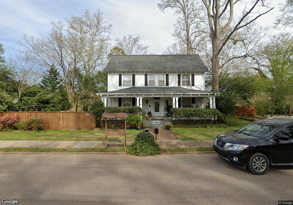
803 Forrest Ave Lagrange, GA 30240
Estimated Value: $175,000 - $232,825
About This Home
This home is located at 803 Forrest Ave, Lagrange, GA 30240 and is currently estimated at $199,706, approximately $96 per square foot. 803 Forrest Ave is a home located in Troup County with nearby schools including Berta Weathersbee Elementary School, Whitesville Road Elementary School, and Rosemont Elementary School.
Ownership History
We collect this data history from publicly available records. To have your information removed, we recommend requesting removal directly through your county’s website.
Purchase Details
Purchase Details
Home Financials for this Owner
Home Financials are based on the most recent Mortgage that was taken out on this home.Purchase Details
Purchase Details
Purchase Details
Purchase History
We collect this data history from publicly available records. To have your information removed, we recommend requesting removal directly through your county’s website.
| Date | Buyer | Sale Price | Title Company |
|---|---|---|---|
| -- | -- | ||
| $88,700 | -- | ||
| -- | -- | ||
| -- | -- | ||
| -- | -- |
Mortgage History
We collect this data history from publicly available records. To have your information removed, we recommend requesting removal directly through your county’s website.
| Date | Status | Borrower | Loan Amount |
|---|---|---|---|
| Previous Owner | $86,000 |
Tax History
We collect this data history from publicly available records. To have your information removed, we recommend requesting removal directly through your county’s website.
| Year | Tax Paid | Tax Assessment Tax Assessment Total Assessment is a certain percentage of the fair market value that is determined by local assessors to be the total taxable value of land and additions on the property. | Land | Improvement |
|---|---|---|---|---|
| 2025 | $1,958 | $78,324 | $3,880 | $74,444 |
| 2024 | $1,733 | $65,524 | $3,880 | $61,644 |
| 2023 | $1,570 | $59,564 | $3,880 | $55,684 |
| 2022 | $1,239 | $54,564 | $3,880 | $50,684 |
| 2021 | $1,302 | $45,168 | $3,880 | $41,288 |
| 2020 | $1,010 | $45,168 | $3,880 | $41,288 |
| 2019 | $1,052 | $42,616 | $3,880 | $38,736 |
| 2018 | $1,175 | $46,700 | $3,860 | $42,840 |
| 2017 | $1,175 | $46,700 | $3,860 | $42,840 |
| 2016 | $1,131 | $45,252 | $3,860 | $41,392 |
| 2015 | $1,131 | $45,252 | $3,860 | $41,392 |
| 2014 | $660 | $29,642 | $3,860 | $25,782 |
| 2013 | -- | $30,464 | $3,860 | $26,604 |
Map
- 801 Forrest Ave
- 807 Forrest Ave
- 809 Forrest Ave
- 811 Forrest Ave
- 813 Forrest Ave
- 602 Lincoln St
- 815 Forrest Ave
- 402 Lincoln St
- 522 Lincoln St
- 604 Lincoln St
- 606 Lincoln St
- 520 Lincoln St
- 700 Dallis St
- 518 Lincoln St
- 817 Forrest Ave
- 516 Lincoln St
- 710 Lincoln St Unit 710
- B Brownwood Ave
- 808 Elm St
- 702 Elm St
Ask me questions while you tour the home.