Estimated Value: $596,000 - $641,000
About This Home
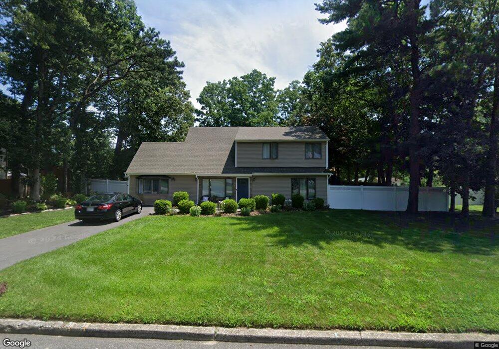
This home is located at 81 Howe Rd, Coram, NY 11727 and is currently estimated at $617,183, approximately $367 per square foot. 81 Howe Rd is a home located in Suffolk County.
Ownership History
We collect this data history from publicly available records. To have your information removed, we recommend requesting removal directly through your county’s website.
Purchase Details
Home Financials for this Owner
Home Financials are based on the most recent Mortgage that was taken out on this home.Purchase Details
Purchase Details
Purchase Details
Home Financials for this Owner
Home Financials are based on the most recent Mortgage that was taken out on this home.Purchase Details
Home Financials for this Owner
Home Financials are based on the most recent Mortgage that was taken out on this home.Purchase Details
Home Financials for this Owner
Home Financials are based on the most recent Mortgage that was taken out on this home.Home Values in the Area
Average Home Value in this Area
Purchase History
We collect this data history from publicly available records. To have your information removed, we recommend requesting removal directly through your county’s website.
| Date | Buyer | Sale Price | Title Company |
|---|---|---|---|
| -- | -- | ||
| -- | -- | ||
| $187,740 | None Available | ||
| $187,740 | None Available | ||
| $551,708 | Webtitle Agency | ||
| $551,708 | Webtitle Agency | ||
| -- | The Judicial Title Ins Agenc | ||
| -- | The Judicial Title Ins Agenc | ||
| -- | Charter Land Title Agency | ||
| -- | Charter Land Title Agency | ||
| $163,000 | -- | ||
| $163,000 | -- |
Mortgage History
We collect this data history from publicly available records. To have your information removed, we recommend requesting removal directly through your county’s website.
| Date | Status | Borrower | Loan Amount |
|---|---|---|---|
| Previous Owner | $354,050 | ||
| Previous Owner | $171,000 | ||
| Previous Owner | $163,200 | ||
| Previous Owner | $146,700 | ||
| Closed | $0 |
Tax History
We collect this data history from publicly available records. To have your information removed, we recommend requesting removal directly through your county’s website.
| Year | Tax Paid | Tax Assessment Tax Assessment Total Assessment is a certain percentage of the fair market value that is determined by local assessors to be the total taxable value of land and additions on the property. | Land | Improvement |
|---|---|---|---|---|
| 2024 | $12,448 | $2,650 | $300 | $2,350 |
| 2023 | $12,448 | $2,650 | $300 | $2,350 |
| 2022 | $11,303 | $2,650 | $300 | $2,350 |
| 2021 | $11,303 | $2,650 | $300 | $2,350 |
| 2020 | $11,539 | $2,650 | $300 | $2,350 |
| 2019 | $11,539 | $0 | $0 | $0 |
| 2018 | $11,046 | $2,650 | $300 | $2,350 |
| 2017 | $11,046 | $2,650 | $300 | $2,350 |
| 2016 | $10,987 | $2,650 | $300 | $2,350 |
| 2015 | -- | $2,650 | $300 | $2,350 |
| 2014 | -- | $2,650 | $300 | $2,350 |
Map
- 36 Holly Hill Ln
- 26 Harford Dr
- 4 Hale Ln
- 21 Halston Ln
- 2 Hamilton Ct
- 981 Old Town Rd
- 29 Harwood Way
- 5 White Oak Ct Unit 5
- 55 Forge Ln
- 19 Hartsdale Ln
- 1984 Route 112
- 14 Gaetano Ln
- 5 Canterbury Dr
- 655 Middle Country Rd Unit 4D1
- 655 Middle Country Rd Unit 2H2
- 655 Middle Country Rd Unit 1G1
- 655 Middle Country Rd Unit 4F1
- 655 Middle Country Rd Unit 2-2E2
- 655 Middle Country Rd Unit 6A2
- 6 Barclay Dr
Ask me questions while you tour the home.