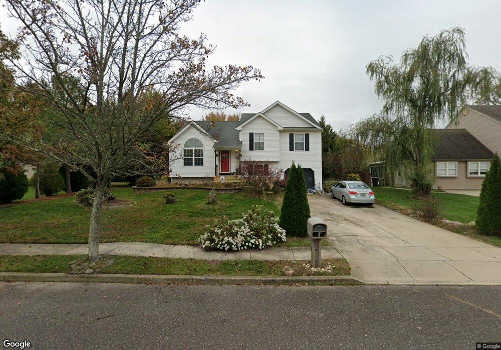
812 Rosetree Dr Williamstown, NJ 08094
Estimated Value: $426,000 - $497,000
Studio
--
Bath
1,830
Sq Ft
$250/Sq Ft
Est. Value
About This Home
This home is located at 812 Rosetree Dr, Williamstown, NJ 08094 and is currently estimated at $456,867, approximately $249 per square foot. 812 Rosetree Dr is a home located in Gloucester County with nearby schools including Williamstown High School, St. Mary School, and Finest of the Wheat Christian.
Ownership History
Date
Name
Owned For
Owner Type
Purchase Details
Closed on
Jun 30, 2000
Sold by
Sanders David H and Sanders Naida A
Bought by
Anderson Daniel E and Anderson Debra A
Current Estimated Value
Home Financials for this Owner
Home Financials are based on the most recent Mortgage that was taken out on this home.
Original Mortgage
$127,920
Outstanding Balance
$45,936
Interest Rate
8.28%
Estimated Equity
$410,931
Purchase Details
Closed on
Feb 28, 1996
Sold by
De Lora Inc
Bought by
Sanders David H and Sanders Naida A
Home Financials for this Owner
Home Financials are based on the most recent Mortgage that was taken out on this home.
Original Mortgage
$124,448
Interest Rate
6.97%
Mortgage Type
FHA
Create a Home Valuation Report for This Property
The Home Valuation Report is an in-depth analysis detailing your home's value as well as a comparison with similar homes in the area
Home Values in the Area
Average Home Value in this Area
Purchase History
| Date | Buyer | Sale Price | Title Company |
|---|---|---|---|
| Anderson Daniel E | $159,900 | -- | |
| Sanders David H | $126,300 | -- |
Source: Public Records
Mortgage History
| Date | Status | Borrower | Loan Amount |
|---|---|---|---|
| Open | Anderson Daniel E | $127,920 | |
| Previous Owner | Sanders David H | $124,448 |
Source: Public Records
Tax History
| Year | Tax Paid | Tax Assessment Tax Assessment Total Assessment is a certain percentage of the fair market value that is determined by local assessors to be the total taxable value of land and additions on the property. | Land | Improvement |
|---|---|---|---|---|
| 2025 | $8,221 | $224,500 | $54,800 | $169,700 |
| 2024 | $8,161 | $224,500 | $54,800 | $169,700 |
| 2023 | $8,161 | $224,500 | $54,800 | $169,700 |
| 2022 | $8,122 | $224,500 | $54,800 | $169,700 |
| 2021 | $8,174 | $224,500 | $54,800 | $169,700 |
| 2020 | $8,165 | $224,500 | $54,800 | $169,700 |
| 2019 | $8,116 | $224,500 | $54,800 | $169,700 |
| 2018 | $7,983 | $224,500 | $54,800 | $169,700 |
| 2017 | $8,037 | $226,900 | $72,800 | $154,100 |
| 2016 | $7,935 | $226,900 | $72,800 | $154,100 |
| 2015 | $7,708 | $226,900 | $72,800 | $154,100 |
| 2014 | $7,483 | $226,900 | $72,800 | $154,100 |
Source: Public Records
Map
Nearby Homes
- 425 Longfellow Dr
- 910 Thoreau Ln
- 1018 Micawber Dr
- 549 Maidstone Dr
- 543 Blue Bell Rd
- 647 Chestnut St
- 971 N Beecham Rd
- 49 Miracle Dr
- 943 Sykesville Rd
- 520 S Main St
- 354 S Main St
- 632 Clayton Rd
- 63 Linwood Ave
- 501 Stockton Dr
- 1361 Black Horse Pike
- 110 Washington Ave Unit M23
- 208 Brandywine Dr
- 415 Stockton Loop
- 336 Copperfield Dr
- 13 S Main St
- 814 Rosetree Dr
- 810 Rosetree Dr
- 816 Rosetree Dr
- 811 Rosetree Dr
- 813 Rosetree Dr
- 808 Rosetree Dr
- 815 Rosetree Dr
- 433 Longfellow Dr
- 818 Rosetree Dr
- 806 Rosetree Dr
- 431 Longfellow Dr
- 435 Longfellow Dr
- 817 Rosetree Dr
- 720 Chatsford Rd
- 437 Longfellow Dr
- 429 Longfellow Dr
- 427 Longfellow Dr
- 718 Chatsford Rd
- 819 Rosetree Dr
- 439 Longfellow Dr
Your Personal Tour Guide
Ask me questions while you tour the home.