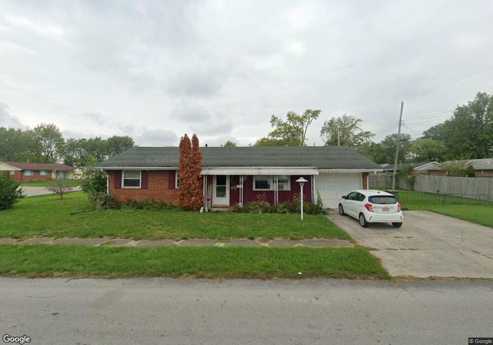
817 Cornell Dr Lima, OH 45805
Westgate NeighborhoodEstimated Value: $117,000 - $136,000
3
Beds
2
Baths
1,040
Sq Ft
$122/Sq Ft
Est. Value
About This Home
This home is located at 817 Cornell Dr, Lima, OH 45805 and is currently estimated at $126,861, approximately $121 per square foot. 817 Cornell Dr is a home located in Allen County with nearby schools including Heritage Elementary School, Lima West Middle School, and Lima North Middle School.
Ownership History
Date
Name
Owned For
Owner Type
Purchase Details
Closed on
Apr 28, 2011
Sold by
Butler Nancy D
Bought by
Leach Cindi M
Current Estimated Value
Home Financials for this Owner
Home Financials are based on the most recent Mortgage that was taken out on this home.
Original Mortgage
$40,000
Outstanding Balance
$26,852
Interest Rate
4.77%
Mortgage Type
Future Advance Clause Open End Mortgage
Estimated Equity
$100,009
Purchase Details
Closed on
Aug 2, 1996
Sold by
Gulker Virgil
Bought by
Thomas Paul and Thomas Betty
Purchase Details
Closed on
Oct 1, 1979
Bought by
Gulker Virgil G and Gulker Doris I
Create a Home Valuation Report for This Property
The Home Valuation Report is an in-depth analysis detailing your home's value as well as a comparison with similar homes in the area
Home Values in the Area
Average Home Value in this Area
Purchase History
We collect this data history from publicly available records. To have your information removed, we recommend requesting removal directly through your county’s website.
| Date | Buyer | Sale Price | Title Company |
|---|---|---|---|
| Leach Cindi M | $50,000 | Attorney | |
| Thomas Paul | $49,500 | -- | |
| Gulker Virgil G | $37,000 | -- |
Source: Public Records
Mortgage History
We collect this data history from publicly available records. To have your information removed, we recommend requesting removal directly through your county’s website.
| Date | Status | Borrower | Loan Amount |
|---|---|---|---|
| Open | Leach Cindi M | $40,000 |
Source: Public Records
Tax History
| Year | Tax Paid | Tax Assessment Tax Assessment Total Assessment is a certain percentage of the fair market value that is determined by local assessors to be the total taxable value of land and additions on the property. | Land | Improvement |
|---|---|---|---|---|
| 2025 | $1,067 | $29,060 | $7,040 | $22,020 |
| 2024 | $1,066 | $29,060 | $7,040 | $22,020 |
| 2023 | $902 | $21,070 | $5,110 | $15,960 |
| 2022 | $907 | $21,070 | $5,110 | $15,960 |
| 2021 | $957 | $21,070 | $5,110 | $15,960 |
| 2020 | $932 | $18,170 | $4,870 | $13,300 |
| 2019 | $932 | $18,170 | $4,870 | $13,300 |
| 2018 | $909 | $18,170 | $4,870 | $13,300 |
| 2017 | $905 | $17,540 | $4,870 | $12,670 |
| 2016 | $912 | $17,540 | $4,870 | $12,670 |
| 2015 | $961 | $17,540 | $4,870 | $12,670 |
| 2014 | $961 | $18,380 | $5,180 | $13,200 |
| 2013 | $936 | $18,380 | $5,180 | $13,200 |
Source: Public Records
Map
Nearby Homes
- 3 Poulston Place
- 1834 Latham Ave
- 926 Crestwood Dr
- 1044 Woodland Dr
- 514 N Cable Rd
- 1600 Leland Ave
- 541 N Nixon Ave
- 511 N Nixon Ave
- 1918 Oakland Pkwy
- 1607 W Wayne St
- 340 N Dale Dr
- 1517 Allentown Rd
- 616 N Rosedale Ave
- 1508 Oakland Pkwy
- 2555 Sherwood Dr
- 124 N Nixon Ave
- 100 Burlington Place
- 1015 N Cole St
- 1209 Rice Ave
- 1440 W Market St
- 749 Mackenzie Dr
- 745 Mackenzie Dr
- 753 Mackenzie Dr
- 1754 Leland Ave
- 1750 Leland Ave
- 741 Mackenzie Dr
- 757 Mackenzie Dr
- 1758 Leland Ave
- 750 Mackenzie Dr
- 1746 Leland Ave
- 746 Mackenzie Dr
- 754 Mackenzie Dr
- 737 Mackenzie Dr
- 1742 Leland Ave
- 00 Mackenzie Dr
- 812 Cornell Dr
- 742 Mackenzie Dr
- 733 Mackenzie Dr
- 1738 Leland Ave
- 738 Mackenzie Dr
Your Personal Tour Guide
Ask me questions while you tour the home.