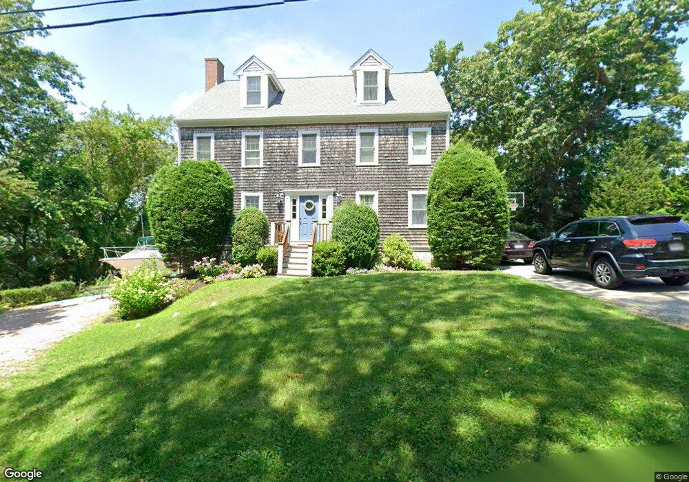
82 Sheridan Dr Marshfield, MA 02050
Ocean Bluff-Brant Rock NeighborhoodEstimated Value: $1,064,000 - $1,386,000
5
Beds
4
Baths
2,856
Sq Ft
$416/Sq Ft
Est. Value
About This Home
This home is located at 82 Sheridan Dr, Marshfield, MA 02050 and is currently estimated at $1,188,176, approximately $416 per square foot. 82 Sheridan Dr is a home located in Plymouth County with nearby schools including Daniel Webster, Furnace Brook Middle School, and Marshfield High School.
Create a Home Valuation Report for This Property
The Home Valuation Report is an in-depth analysis detailing your home's value as well as a comparison with similar homes in the area
Home Values in the Area
Average Home Value in this Area
Tax History
| Year | Tax Paid | Tax Assessment Tax Assessment Total Assessment is a certain percentage of the fair market value that is determined by local assessors to be the total taxable value of land and additions on the property. | Land | Improvement |
|---|---|---|---|---|
| 2025 | $9,772 | $987,100 | $325,600 | $661,500 |
| 2024 | $9,417 | $906,400 | $305,300 | $601,100 |
| 2023 | $8,866 | $798,200 | $274,800 | $523,400 |
| 2022 | $8,866 | $684,600 | $234,000 | $450,600 |
| 2021 | $8,297 | $629,000 | $223,900 | $405,100 |
| 2020 | $7,826 | $587,100 | $193,300 | $393,800 |
| 2019 | $7,550 | $564,300 | $193,300 | $371,000 |
| 2018 | $7,444 | $556,800 | $193,300 | $363,500 |
| 2017 | $7,207 | $525,300 | $183,200 | $342,100 |
| 2016 | $6,533 | $470,700 | $173,000 | $297,700 |
| 2015 | $6,160 | $463,500 | $173,000 | $290,500 |
| 2014 | $6,042 | $454,600 | $173,000 | $281,600 |
Source: Public Records
Map
Nearby Homes
- 91 Winslow St
- 120 Monitor Rd
- 155 Quincy Ave
- 107 Towne Way
- 1080 Ocean St
- 1028 Ocean St
- 1221 Ocean St
- 21 Washington Ave
- 134 Wellington Ave
- 18 Somerville St
- 8 Duxbury St
- 757 S River St
- 204 Foster Ave
- 19 Copeland St
- 12 Julian St
- 30 Tupelo Rd
- 71 Webster Ave
- 173 S River St
- 713 Webster St
- 46 Fairways Edge Dr
- 94 Sheridan Dr
- 95 Sheridan Dr
- 27 Crestwood Ave
- 83 Sheridan Dr
- 565566 Sheridan Dr
- 76 Sheridan Dr
- 77 Sheridan Dr
- 86 Homestead Ave
- 86 Homestead Ave
- 15 Crestwood Ave
- 72 Sheridan Dr
- 26 Crestwood Ave
- 78 Homestead Ave
- 68 Sheridan Dr
- 69 Sheridan Dr
- 9 Crestwood Ave
- 66 Homestead Ave
- 16 Crestwood Ave
- 64 Sheridan Dr
- 65 Sheridan Dr
Your Personal Tour Guide
Ask me questions while you tour the home.