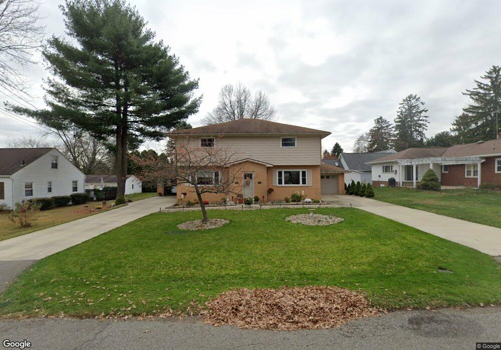
821 Thorne Ave Wooster, OH 44691
Estimated Value: $224,000 - $338,000
6
Beds
4
Baths
2,880
Sq Ft
$97/Sq Ft
Est. Value
About This Home
This home is located at 821 Thorne Ave, Wooster, OH 44691 and is currently estimated at $279,990, approximately $97 per square foot. 821 Thorne Ave is a home located in Wayne County with nearby schools including Melrose Elementary School, Edgewood Middle School, and Wooster High School.
Ownership History
Date
Name
Owned For
Owner Type
Purchase Details
Closed on
Aug 8, 2022
Sold by
Linhoss Philip L and Linhoss Josann
Bought by
Linhoss Family Irrevocable Trust
Current Estimated Value
Purchase Details
Closed on
Jan 10, 1990
Sold by
Hoch Louise and Elaine Rose
Bought by
Linhoss Philip L and Linhoss Josann
Create a Home Valuation Report for This Property
The Home Valuation Report is an in-depth analysis detailing your home's value as well as a comparison with similar homes in the area
Home Values in the Area
Average Home Value in this Area
Purchase History
| Date | Buyer | Sale Price | Title Company |
|---|---|---|---|
| Linhoss Family Irrevocable Trust | -- | Hawks Nicole M | |
| Linhoss Family Irrevocable Trust | -- | None Listed On Document | |
| Linhoss Philip L | $87,500 | -- |
Source: Public Records
Tax History
| Year | Tax Paid | Tax Assessment Tax Assessment Total Assessment is a certain percentage of the fair market value that is determined by local assessors to be the total taxable value of land and additions on the property. | Land | Improvement |
|---|---|---|---|---|
| 2025 | $3,874 | $92,840 | $12,880 | $79,960 |
| 2024 | $3,874 | $92,840 | $12,880 | $79,960 |
| 2023 | $3,890 | $92,840 | $12,880 | $79,960 |
| 2022 | $3,700 | $70,330 | $9,760 | $60,570 |
| 2021 | $3,816 | $70,330 | $9,760 | $60,570 |
| 2020 | $3,620 | $70,330 | $9,760 | $60,570 |
| 2019 | $2,831 | $52,790 | $9,080 | $43,710 |
| 2018 | $2,839 | $52,790 | $9,080 | $43,710 |
| 2017 | $2,823 | $52,790 | $9,080 | $43,710 |
| 2016 | $2,950 | $50,760 | $8,730 | $42,030 |
| 2015 | $2,897 | $50,760 | $8,730 | $42,030 |
| 2014 | $2,898 | $50,760 | $8,730 | $42,030 |
| 2013 | $3,042 | $52,700 | $8,820 | $43,880 |
Source: Public Records
Map
Nearby Homes
- 606 E Wayne Ave
- 2050 Allandale Dr
- 702 Sherwood Dr
- 2251 Robinhood Dr
- 2208 Cleveland Rd
- 2214 Cleveland Rd
- 2011 Burbank Rd
- 1117 Quinby Ave
- 716 Washington St
- 1 Wimpole St
- 856 E Highland Ave
- 503 Oakmont Ct Unit 503
- 1718 Armadale Isle
- 2596 Eastwood Dr
- 900 Quinby Ave
- 594 Forest Creek Dr
- 539 Forest Creek Dr Unit 6842
- V/L 6838 Forest Creek Dr
- 708 N Bever St
- 2632 Peach Ln
Your Personal Tour Guide
Ask me questions while you tour the home.