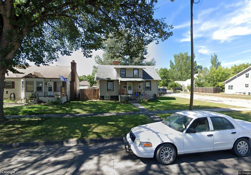
824 Platte Ave Alliance, NE 69301
Estimated Value: $112,000 - $148,000
2
Beds
1
Bath
1,412
Sq Ft
$95/Sq Ft
Est. Value
About This Home
This home is located at 824 Platte Ave, Alliance, NE 69301 and is currently estimated at $133,604, approximately $94 per square foot. 824 Platte Ave is a home located in Box Butte County with nearby schools including Alliance High School, St. Agnes Academy, and Immanuel Evangelical Lutheran School.
Ownership History
Date
Name
Owned For
Owner Type
Purchase Details
Closed on
Nov 25, 2025
Sold by
Rebillet John H and Rebillet Kari R
Bought by
Rebillet Rentals Llc
Current Estimated Value
Purchase Details
Closed on
Nov 10, 2025
Sold by
Rebillet John and Rebillet Kari
Bought by
Rebillet John and Rebillet Kari
Purchase Details
Closed on
Nov 21, 2017
Sold by
Garry Rasmussen
Bought by
Rebillet John and Rebillet Kari
Purchase Details
Closed on
Nov 18, 2013
Bought by
Rasmussen Garry and Rasmussen Kelly
Home Financials for this Owner
Home Financials are based on the most recent Mortgage that was taken out on this home.
Original Mortgage
$70,000
Interest Rate
4.17%
Mortgage Type
Future Advance Clause Open End Mortgage
Create a Home Valuation Report for This Property
The Home Valuation Report is an in-depth analysis detailing your home's value as well as a comparison with similar homes in the area
Home Values in the Area
Average Home Value in this Area
Purchase History
| Date | Buyer | Sale Price | Title Company |
|---|---|---|---|
| Rebillet Rentals Llc | -- | None Listed On Document | |
| Rebillet John | -- | None Listed On Document | |
| Rebillet John | $49,000 | -- | |
| Rasmussen Garry | -- | Kunzman Title |
Source: Public Records
Mortgage History
| Date | Status | Borrower | Loan Amount |
|---|---|---|---|
| Previous Owner | Rasmussen Garry | $70,000 |
Source: Public Records
Tax History
| Year | Tax Paid | Tax Assessment Tax Assessment Total Assessment is a certain percentage of the fair market value that is determined by local assessors to be the total taxable value of land and additions on the property. | Land | Improvement |
|---|---|---|---|---|
| 2025 | $1,403 | $118,179 | $4,950 | $113,229 |
| 2024 | $1,346 | $107,435 | $4,500 | $102,935 |
| 2023 | $1,847 | $107,435 | $4,500 | $102,935 |
| 2022 | $872 | $47,870 | $4,250 | $43,620 |
| 2021 | $882 | $47,870 | $4,250 | $43,620 |
| 2020 | $880 | $47,870 | $4,250 | $43,620 |
| 2019 | $859 | $47,870 | $4,250 | $43,620 |
| 2018 | $855 | $47,870 | $4,250 | $43,620 |
| 2017 | $870 | $46,890 | $3,250 | $43,640 |
| 2016 | $860 | $46,890 | $3,250 | $43,640 |
| 2015 | $870 | $44,420 | $3,250 | $41,170 |
| 2014 | $870 | $44,480 | $3,250 | $41,230 |
Source: Public Records
Map
Nearby Homes
- 819 Black Hills Ave
- 823 Emerson Ave
- 928 Black Hills Ave
- 607 Black Hills Ave
- 719 Toluca Ave
- 1021 Dakota Ave
- 1034 Dakota Ave
- 1228 Emerson Ave
- 408 Toluca Ave
- 1232 Emerson Ave
- 506 Cheyenne Ave
- 1103 Cheyenne Ave
- 114 W 8th St
- 1232 Cheyenne Ave
- 1329 Buchfinck Ave
- 122 W 4th St
- 1442 Boise Ave
- 112 E 11th St
- 20th St Emerson Ave To Colorado Ave
- 1216 Duncan Ave
- 820 Platte Ave
- 711 W 9th St
- 816 Platte Ave
- 710 W 9th St
- 904 Platte Ave
- 812 Platte Ave
- 815 Black Hills Ave
- 823 Platte Ave
- 808 Platte Ave
- 819 Platte Ave
- 912 Platte Ave
- 901 Black Hills Ave
- 811 Black Hills Ave
- 815 Platte Ave
- 903 Platte Ave
- 811 Platte Ave
- 804 Platte Ave
- 907 Platte Ave
- 807 Black Hills Ave
- 916 Platte Ave
Your Personal Tour Guide
Ask me questions while you tour the home.