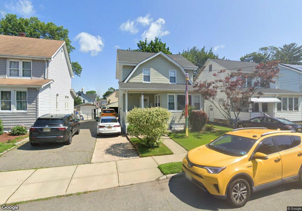
84 Locust Ave Dumont, NJ 07628
Estimated Value: $524,000 - $595,000
3
Beds
2
Baths
1,382
Sq Ft
$411/Sq Ft
Est. Value
About This Home
This home is located at 84 Locust Ave, Dumont, NJ 07628 and is currently estimated at $568,457, approximately $411 per square foot. 84 Locust Ave is a home located in Bergen County with nearby schools including Dumont High School and Institute For Educational Achievement.
Ownership History
Date
Name
Owned For
Owner Type
Purchase Details
Closed on
Oct 23, 2017
Sold by
Saudino Michael
Bought by
Pnc Bank Na
Current Estimated Value
Purchase Details
Closed on
Nov 17, 2007
Sold by
Cabral Manuel and Cabral Fanis L
Bought by
Cabral Fanis L
Purchase Details
Closed on
Oct 20, 2005
Sold by
Brunck Eileen
Bought by
Cabral Manuel and Cabral Fanis
Home Financials for this Owner
Home Financials are based on the most recent Mortgage that was taken out on this home.
Original Mortgage
$303,920
Interest Rate
5.79%
Create a Home Valuation Report for This Property
The Home Valuation Report is an in-depth analysis detailing your home's value as well as a comparison with similar homes in the area
Home Values in the Area
Average Home Value in this Area
Purchase History
| Date | Buyer | Sale Price | Title Company |
|---|---|---|---|
| Pnc Bank Na | -- | -- | |
| Cabral Fanis L | -- | -- | |
| Cabral Manuel | $379,900 | -- |
Source: Public Records
Mortgage History
| Date | Status | Borrower | Loan Amount |
|---|---|---|---|
| Previous Owner | Cabral Manuel | $303,920 |
Source: Public Records
Tax History
| Year | Tax Paid | Tax Assessment Tax Assessment Total Assessment is a certain percentage of the fair market value that is determined by local assessors to be the total taxable value of land and additions on the property. | Land | Improvement |
|---|---|---|---|---|
| 2025 | $10,602 | $491,900 | $268,300 | $223,600 |
| 2024 | $10,341 | $260,800 | $140,200 | $120,600 |
| 2023 | $10,127 | $260,800 | $140,200 | $120,600 |
| 2022 | $10,127 | $260,800 | $140,200 | $120,600 |
| 2021 | $10,077 | $260,800 | $140,200 | $120,600 |
| 2020 | $9,803 | $260,800 | $140,200 | $120,600 |
| 2019 | $9,569 | $260,800 | $140,200 | $120,600 |
| 2018 | $9,373 | $260,800 | $140,200 | $120,600 |
| 2017 | $9,193 | $260,800 | $140,200 | $120,600 |
| 2016 | $8,979 | $260,800 | $140,200 | $120,600 |
| 2015 | $8,773 | $260,800 | $140,200 | $120,600 |
| 2014 | $8,601 | $260,800 | $140,200 | $120,600 |
Source: Public Records
Map
Nearby Homes
- 158 W Madison Ave
- 94 W Madison Ave
- 71 W Madison Ave
- 28 Park Ave
- 16 Roosevelt Ave
- 183 Ames Ave
- 4 Banta Place
- 95 W Shore Ave
- 201 Dixon Ave
- 25 Ralph St
- 83 N Washington Ave
- 41 W Church St Unit 11
- 144 New Milford Ave
- 125 Merritt Ave
- 34 N Washington Ave
- 110 New York Ave
- 55 New York Ave
- 125 W Main St
- 40 Depew St
- 40 Morton Ave
Your Personal Tour Guide
Ask me questions while you tour the home.