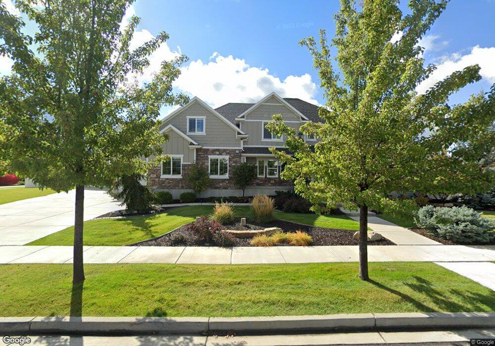
841 W 675 S Mapleton, UT 84664
Estimated Value: $1,577,000 - $2,175,000
7
Beds
5
Baths
5,767
Sq Ft
$308/Sq Ft
Est. Value
About This Home
This home is located at 841 W 675 S, Mapleton, UT 84664 and is currently estimated at $1,774,579, approximately $307 per square foot. 841 W 675 S is a home located in Utah County with nearby schools including Mapleton School, Mapleton Junior High School, and Maple Mountain High School.
Ownership History
Date
Name
Owned For
Owner Type
Purchase Details
Closed on
Feb 23, 2023
Sold by
Hughes Michael R and Hughes Courtney
Bought by
Holly Heward Family Trust
Current Estimated Value
Purchase Details
Closed on
Jul 29, 2011
Sold by
Pepperdign Homes Llc
Bought by
Hughes Michael R and Hughes Courtney
Purchase Details
Closed on
Feb 1, 2011
Sold by
Black Mountain Enterprises Llc
Bought by
Pepperdign Homes Llc
Create a Home Valuation Report for This Property
The Home Valuation Report is an in-depth analysis detailing your home's value as well as a comparison with similar homes in the area
Home Values in the Area
Average Home Value in this Area
Purchase History
| Date | Buyer | Sale Price | Title Company |
|---|---|---|---|
| Holly Heward Family Trust | -- | Traveling Title | |
| Hughes Michael R | -- | Gateway Title Ins Agency | |
| Pepperdign Homes Llc | -- | None Available |
Source: Public Records
Tax History
| Year | Tax Paid | Tax Assessment Tax Assessment Total Assessment is a certain percentage of the fair market value that is determined by local assessors to be the total taxable value of land and additions on the property. | Land | Improvement |
|---|---|---|---|---|
| 2025 | $7,307 | $829,950 | -- | -- |
| 2024 | $7,307 | $715,770 | $0 | $0 |
| 2023 | $7,681 | $757,240 | $0 | $0 |
| 2022 | $8,316 | $810,645 | $0 | $0 |
| 2021 | $7,227 | $1,081,600 | $271,200 | $810,400 |
| 2020 | $7,041 | $1,019,200 | $240,000 | $779,200 |
| 2019 | $6,576 | $971,600 | $240,000 | $731,600 |
| 2018 | $6,482 | $911,700 | $205,000 | $706,700 |
| 2017 | $6,607 | $493,185 | $0 | $0 |
| 2016 | $6,263 | $464,750 | $0 | $0 |
| 2015 | $5,491 | $404,965 | $0 | $0 |
| 2014 | $5,368 | $388,850 | $0 | $0 |
Source: Public Records
Map
Nearby Homes
- 896 W 675 S
- 415 S 1200 W
- 509 W 350 S Unit 30
- 4664 S 680 W Unit S204
- 4664 S 680 W Unit S203
- 4664 S 680 W Unit S302
- 4664 S 680 W Unit S303
- 4664 S 680 W Unit S201
- 4664 S 680 W Unit S202
- 4664 S 680 W Unit S304
- 4664 S 680 W Unit S301
- 4664 S 680 W Unit S102
- 4664 S 680 W Unit S101
- 1158 S 980 W
- 1352 W 900 S
- 715 W 4600 S Unit Lot I303
- 715 W 4600 S Unit Lot I304
- 126 N 800 W
- 1222 W 190 N
- 1655 W 200 S Unit A
Your Personal Tour Guide
Ask me questions while you tour the home.